Albany, Fort
Description: Following the conquest of New Netherland in 1664, the territory that would later become New York State was ceded to the English. To maintain peace in Albany, Fort Frederick was constructed in 1676 to replace the then decaying Fort Orange. Fort Frederick, also known as Fort Albany in the 1936 novel, Drums Along the Mohawk, was named for the Prince of Wales, Frederick Louis. Strangely, the prince was not born until 1707, decades after the initial construction.
Submitted by Cliff Lamere, Albany, NY:
"I have only heard of two dates for dimantling the fort; 1784 which is before the Common Council decision to tear it down, and 1789...We know that the land on which the fort rested was deeded to St. Peter's Episcopal Church in 1790"
County: Albany
City, State: Albany, NY
Alden, Fort
Description: Fort Alden was constructed in 1778, in Cherry Valley, Ostego County, New York, and remained intact for only two years during the Revolutionary War. The facility was named for Colonel Ichabod Alden, who commanded the fortress. Alden, along with fifteen other soldiers were killed in a surprise attack perpetrated by British loyalists in 1778. The fortress was besieged a second time in 1780 and was subsequently destroyed.
Notes:
- A previous stockade on the site existed and was destroyed in the French and Indian War. It was replaced by Fort Campbell, named for Commander of Continental troops there.
- Fort Alden possibly hosted two blockhouses.
-First attack took place on November 11th, 1778
-Second attack took place in April of 1780
- The site is now marked by the Cherry Valley Cemetery.
County: Otsego
City, State: Cherry Valley, NY
Amboy Ferry Post
Description: Amboy Ferry Post, 1777, Staten Island. British fortifications on southwestern shore of Staten Island and garrisoned by three companies.
County: Richmond
City, State: Staten Island, NY
Amersfort Blockhouse
Description: The Amersfoort Blockhouse was a Dutch fortification founded in 1630 and decommissioned in 1664. It was located in the flatlands of Brooklyn, in Kings County, New York. It is likely named for the Dutch city of Amersfoort, founded in 1259.
County: Kings
City, State: Brooklyn, New York City, NY
Amherst, Fort (1)
Description: Fort Crown Point was constructed in 1759 adjacent to Lake Champlain, in Northern New York, on the border with what would later become Vermont. The fort is often incorrectly referred to as “Fort Amherst”, as the facility was constructed under the command of Sir Jeffery Amherst of England. However, this name was never used until far after the fort was abandoned in 1780. The best-preserved remains of the fort are its stone barracks. Fort Crown Point was designated as a National Historic Landmark in 1968. The fort was also visited by various Founding Fathers, including Benjamin Franklin, George Washington, Thomas Jefferson, and James Madison.
County: Warren County
City, State: Queensbury, New York
Amherst, Fort (2)
Description: Fort Amherst, initially called “Fort Miller”, was constructed in 1759 by the British just north of Glenn Falls, and close to what is now Lake George in Warren County, New York. It was demolished in 1760 and rebuilt fifteen years later by American soldiers just a year prior to the Revolutionary War. In 1777, Hessians, German soldiers who fought on the side of the British during the Revolution, occupied the fort. In 1780, Fort Amherst met its end after being brought to the torch by British forces.
Notes:
- The fort was located at the halfway point between Fort Edward and Fort William Henry/Fort George.
- The fort was once a fortified camp between 1757 and 1758.
- Also near this site was a stockaded enclosure known as Seven-mile post, or Halfway Brook Post, from 1755 to 1776, and a stockaded Garrison in 1758.
County: Warren County
City, State: Queensbury, New York
Amityville Nike Base
Description: Amityville Nike Base (NY-24), 1957-74, Suffolk County, Amityville. Launcher Area for 30 Nike-Ajax Missiles, later converted to 18 Nike-Hercules Missiles, Integrated Fire Control area was Farmingdale. Inactivated 1974. Site on Farmingdale Road, now Zahn Airport, the launch area is a Reserve Center with the missile pits cemented over for a motor pool. All buildings and double fence intact.
For more sites see NIKE and for more information see alpha.fdu.edu/~bender/NY24.html (Link will open new window.)
County: Suffolk County
City, State: Amityville, New York
Amsterdam, Fort
Description: Fort Amsterdam was constructed by the Dutch West India Company in 1626 on the southern end of the island of Manhattan. It served as an administrative hub for the Dutch, specifically the Dutch West India Company, and later fell under control of the British after the conquest of New Netherland in 1664. The fort remained in operation for an incredible 164 years but was torn down by the United States in 1790. The fort was involved in many famous battles and wars such as the Battle of Long Island, the Second and Third Anglo-Dutch Wars, and the American Revolution.
Notes:
- The British renamed the fortification "Fort James" in August of 1664. It maintained this name until 1687-1703 when it was renamed once again, then being known as "Fort George".
- The fort was briefly reoccupied by the Dutch in 1673 to 1674, during which time it went by the name "Fort Willem Hendrick".
- The fort is located on the site of what is now the Old Custom House at the foot of Broadway.
County: New York County
City, State: New York City, NY
Anne, Fort
Description: Fort Anne (1), 1711, Washington County, Village of Fort Ann. On the major land route from the Hudson (Fort Edward southern terminus) to forks of Wood Creek (northern terminus) and access to Lake Champlain. Site was first occupied as a fortified camp in 1690 on the way to invade Canada in King William's War, then again in 1692 during another expedition. Queen Anne's war started in 1702 and the site was fortified as Fort Schuyler in 1709 and destroyed the same year. Rebuilt in 1711 as Queen's Fort (2) and then renamed Fort Anne. Both of these were 140 foot square palisades with interior earth fill, two large interior buildings, and 20 foot square bastion on each corner. . Restored again in 1757 and used in the French and Indian War, with the addition of stone arsenal and magazine. Mud Fort, 1769 was nearby in suburb or Needhamville. Used as a temporary Headquarters of Gen Schuyler in 1777. Located on Burgoynes route to Saratoga in 1777 and location of sawmill for Arnold's Lake Champlain Fleet. Destroyed upon withdrawal when Burgoyne reached Skenesboro. Another fort was erected after the Battle of Saratoga but was surrendered and burned in Oct 1780. A reconstruction of a blockhouse from original plans was done in 1954 as a tourist stop, and is now a bank.
For more information see www.adirondack.net/TOWNS/FortAnn/
Fort Anne (2), 1703, New York City. See Fort George.
County: Washington County
City, State: Fort Ann, New York
Anti-Motor-Torpedo-Boat Batteries
Description: AMTB #11 Battery, 1941-1949, Miller Field, Staten Island. The Anti-Motor-Torpedo-Boat (AMTB) 90mm gun M1 on mount M3 was developed in 1941 to provide a weapon that was effective against fast torpedo boats, aircraft, and land targets. It could be controlled manually or automatically through a remote control system. A protective shield was installed around the gun and allowed crew access and gun loading through the rear.
AMTB #12 Battery, 1941-1949, Swinburne Island, NY (adjacent to Hoffman Island in the Narrows). The Anti-Motor-Torpedo-Boat (AMTB) 90mm gun M1 on mount M3 was developed in 1941 to provide a weapon that was effective against fast torpedo boats, aircraft, and land targets. It could be controlled manually or automatically through a remote control system. A protective shield was installed around the gun and allowed crew access and gun loading through the rear.
AMTB #19 Battery, 1941-1949, Norton Point (Western tip of Coney Island, Brooklyn). The Anti-Motor-Torpedo-Boat (AMTB) 90mm gun M1 on mount M3 was developed in 1941 to provide a weapon that was effective against fast torpedo boats, aircraft, and land targets. It could be controlled manually or automatically through a remote control system. A protective shield was installed around the gun and allowed crew access and gun loading through the rear.
AMTB #21 Battery, 1941-1949, Kings Co., Fort Tilden. The Anti-Motor-Torpedo-Boat (AMTB) 90mm gun M1 on mount M3 was developed in 1941 to provide a weapon that was effective against fast torpedo boats, aircraft, and land targets. It could be controlled manually or automatically through a remote control system. A protective shield was installed around the gun and allowed crew access and gun loading through the rear. The AMTB Battery at Rockaway Point, also known as Breezy Point, was not located inside Fort Tilden, but at the tip of the Rockaway peninsula. This gun battery protected the entrance to Jamaica Bay. Battery #20, consisting of two 3-inch guns Model 1902 mounted on barbette carriages Model 1905 was also located in this vicinity.
County: Richmond County; Kings County; Queens County
City, State: Staten Island, NY; Swinburne Island, NY; Brooklyn, NY; Breezy Point, NY
Arnold, Fort
Description: Fort Clinton, originally named for perhaps history’s most infamous traitor, Benedict Arnold, was constructed during the Revolutionary War in 1780. During the construction, the fortification was under the supervision of Colonel Tadeusz Kościuszko. The fort was built near what is now West Point, in Orange County, New York.
In the aftermath of the Revolutionary War, the fort was left to decay before being demolished toclear space for the expansion of the United States Military Academy founded nearby in 1802. Today, some remnants of Fort Clinton, such as the stone foundation remain visible.
Notes:
- The fort's construction started during February of 1778.
- The structure was located opposite Constitution Island.
- The fort served as the west anchor of the 1778 West Point chain.
County: Orange County
City, State: West Point, New York
Arnot Barracks
Description: Arnot Barracks, 1860s, Chemung County, Elmira. Used as a Civil War POW Camp.
County: Chemung County
City, State: Elmira, New York
Arthur, Camp
Description: Camp Arthur, 1862, Staten Island. Civil War Training Camp.
County: Richmond County
City, State: Staten Island, New York
Atlas Sites
Description: Atlas Sites, 1961, a 12-missile Atlas F ICBM squadron (the 556th Strategic Missile Squadron) became operational 1 October 1961 at Plattsburgh AFB, NY,. The Atlas Fs were removed from alert on 25 June 1965. Ten of these 12 sites are in New York State, the other two in Vermont. The New York sites were at (1) Champlain, (4) Willsboro, (5) Lewis, (6) Au Sable Forks, (7) Riverview, (8) Redford, (9) Dannemora, (10) Brainardsville, (11) Ellenburg Depot, and (12) Mooers. The first Atlas F missile system was built in 1960, after a short operational period, was decommissioned in 1965. These sites were the first of the "super hardened"; missile silos, built to withstand a 200 pound per square inch blast. There is one reported in Saranac Lake area not listed in official records.
General Layout: These sites consist of several general elements: Command Building: Two stories 40 feet in diameter. Access was by stairs and through two blast proof doors. Approximately 2,363 square feet of floor space not including stairway or vestibule. Due to the insulation of the earth, heating and cooling needs were minimal.
Missile Silo: The missile silo was a huge structure 50 feet in diameter and approximately 185 feet deep. Access was from a 40 foot tunnel leading from the command building stairway. Missile silo had an approximate volume of 363,062 cubic feet.
Land: Land typically was 19-21 acres. Originally, the inner 5 acres of these sites were surrounded by a barbed wire topped chain link fence.
Status: All sites are now in private ownership, all materials were salavaged before they were sold but the structures remain intact as last reported in 1996.
For more Infomation go to www.siloworld.com
County: Clinton County
City, State: Plattsburgh, New York
Au Fer, Fort
Description: Fort au Fer was constructed by British forces in 1775 on the coast of Lake Champlain, in Northern New York. Bizarrely, the fort remained under British control until 1796. In 1794, the United States and Great Britain came to an agreement (the Jay Treaty of 1794) to settle a wide variety of ongoing issues, including the British occupation of forts in Northern New York. After falling under American control, the fort eventually fell victim to a fire in 1805 and was destroyed.
Notes:
- The fort was located one mile south of Rouses Point
- A large stone house from 1770 was fortified with cannon and entrenchments in 1775, with additional brick barracks and stockade.
County: Clinton County
City, State: Lake Champlain, New York
Au Sable Atlas
Description: Au Sable Forks, ATLAS F, Site #6: 1961-65, Essex County, Au Sable Forks. see ATLAS F for detailed information.
County: Essex County
City, State: Au Sable Forks, New York
Augusta, Fort
Description: Fort Augusta, 1755, Orange County, Port Jervis vicinity. A fort from the Colonial Wars on the Delaware River.
County: Orange County
City, State: Port Jervis, New York
Augustus, Fort William
Description: Fort Lévis, eventually known as Fort William Augustus, was constructed by the French in 1759, and seized by the British in 1760 during the Seven Years’ War. The fort was originally named after French Marshal, François Gaston de Lévis, and rebranded by the British in honor of then head of the British Army and Duke of Cumberland, Prince William Augustus. The French constructed the fort near Ogdensburg, New York on an island surrounded by the St. Lawrence River. It was built for the purpose of supporting the existing Fort de La Présentation as a means to bolster a potential defense against possible British attacks on the area. However, this plan failed, and shortly after the fort’s seizure by the British, it was briefly maintained until its abandonment in 1766.
County: St. Lawrence County
City, State: Ogdensburg, New York
Aurania Stockade
Description: Aurania Stockade, 1624, Rensselaer County, Rensselaer. Stockaded village of French Protestants located near later Fort Crailo.
County: Rensselaer County
City, State: Rensselaer, New York
Balcarres Redoubt
Description: Balcarres Redoubt, 1777, Saratoga County, Bemis Heights. October 1777, Battle of Saratoga. A strong British position 500 yards long and 12 to 14 feet high, mounting 8 guns. Incorporated the Freeman House. Located south of Brymann Redoubt.
For more information see www.revolutionaryday.com/usroute4/saratoga/tour6.htm (Link will open new window.)
County: Saratoga County
City, State: Bemis Heights
Balls Town, Fort
Description: Fort Balls Town, 1775 (or 1772) Saratoga County, Town of Ballston, Ballston Lake. Stockaded fort, Site at intersection of Route 50 and Carleton Road. Survived to 1783. Sometime location given as Front St. in Village that marker now removed. Town Historical Marker is now at this location.
Site of Rev. Ball's Log Church - 1771. Ballston Town Commons - 1774. Stockaded fort - 1775. Red Meeting House - 1780. Ballston Academy - 1804.
County: Saratoga County
City, State: Ballston (Spa), New York
Barrier Gate, The
Description: The Barrier Gate, 1779, New York County, New York City. A line of British fortifications from Fort Tryon in the West to Fort George on Laurel Hill in the East. The works consisted of a number of stockades and five redoubts. This fortified line was called the Barrier Gate.
County: New York County
City, State: New York City, New York
Bath Beach Blockhouse
Description: Bath Beach Blockhouse, 1814-1815, Bath Beach, Kings County. One of several blockhouses for the defense of NY Harbor ordered by Gen Joseph Smith, Chief of Engineers. (Bath Beach, Utrecht Bay, Denyse's Heights, Princess Bay, Jamaica Bay - Decatur) Records are not clear that all of the sites were constructed.
For more information see www.geocities.com/fort_tilden/bhp.html. (Link will open new window.)
County: Kings County
City, State: Brooklyn, New York
Battery Harris
Description: Battery Harris: 1921-1949, Kings Co., Fort Tilden. Two model M1919 MII 16 inch guns originally manufactured at the Watervliet Arsenal for Naval ships. Originally in open "Panama" mounts, they were casemented in the early 1940s. Range was 30 miles. The battery originally had two fire control towers that could azimuth the target. By 1944 the battery had seven base stations, ten spotting stations, and eight radar installations to direct fire.
County: Queens
City, State: Rockaway Peninsula, New York
Battery Kessler
Description: Battery Kessler: 1917-1949, Kings Co., Fort Tilden. Originally called West Battery, named for Col. Percy Kessler, December 1939. Two model 1900, 6 inch "rapid fire" guns with a range of 16,550 yards.
County: Kings
City, State: Fort Tilden, New York
Battery Weed
Description: Battery Weed: Later name of Fort Richmond. Named for Brev. BG Steven Weed killed at Gettysburg.
County: New York
City, State: Staten Island, New York
Battle of Wilton
Description: Battle of Wilton: 1693, Town of Wilton, Kings Station, intersection of Parkhurst and Greenfield Roads, Saratoga County. Site of British - French engagement.
County: Saratoga
City, State: Wilton, New York
Becker Fort
Description: Becker Fort, Date unknown, Port Jervis, Orange County.
County: Orange County
City, State: Port Jervis. New York
Bender, Fort
Description: The story of Fort Bender, built in 1814, reflects the very same American ingenuity that led the Continental Army to an unlikely victory in the Revolutionary War three decades prior. Located near Lake Ontario, in Rochester, New York, the fort was hastily constructed as an intimidation tactic during the war of 1812. During the conflict, the citizens of Rochester, New York, feared a possible British invasion of their town, but, unfortunately, had less than three dozen soldiers to defend their livelihoods. So, to appear more formidable and numerous to onlooking armies, the soldiers constructed the fort and named it for Rochester resident Hastings R. Bender. Astonishingly, their gamble paid off, and the world’s strongest military was tricked into thinking that the measly militia of thirty-three untrained citizen soldiers were far stronger than they actually were. The ruse was a success; incredibly, the British decided against moving to capture Rochester.
County: Monroe County
City, State: Rochester, New York
Black Rock, Fort
Description: Fort Black Rock, 1807, Erie County, Buffalo. Shown on map at Black Rock Creek, north of Buffalo. Near future Fort Porter. Near site of Battle of Black Rock in War of 1812.
County: Erie County
City, State: Buffalo, New York
Bloody Pond, Battle of
Description: Bloody Pond (Battle), 1755 and 1780, Lake George, Warren Co. Here Sept. 8, 1755 (Battle of Lake George) the Colonial Forces under Lieut. Col. Cole checked the hitherto successful advance of Baron Dieskau and his allies, changing the British rout into ultimate victory.
Here likewise on the evening of the same day - Capt. McGinnis assisted by Capt. Folsom with 200 New York and New Hampshire men, fell upon 300 Canadians and Indians encamped near the pond for the night. After a desperate struggle the French force was almost annihilated. Over 200 bodies rolled into the pool stained the water red and gave it its name. In this conflict Rogers, the famous Ranger made his debut as a soldier.
Near this spot Oct. 11, 1780 Major Christopher Carleton and his band of Regulars, Tories and Indians, defeated with great loss, Captain John Sill and an American detachment from Fort George forcing the surrender of that station.
For more information see: www.historiclakes.org/wm_henry/bloody.html (Link will open new window.)
County: Warren County
City, State: Lake George, New York
Bluefields, Camp
Description: Camp Bluefields, pre 1915, Rockland County, Town of Blauvelt. Former New York National Guard Rifle Range used as POW Camp in WW1. Now a County Park.
County: Rockland County
City, State: Blauvelt, New York
Boeing and Michigan Aerospace Research Center (BOMARC)
Description: BOMARC, The missle site in Westhampton was operated by the 6th Air Defense Missle Squadron of the USAF Air Defense Command (ADC). It was operational with the first version of the BOMARC missle, the BOMARC A, from 1959 through 1964. The base has 56 missle shelters. Each missle was armed with a 10-Kiloton nuclear warhead. The former missle site is currently used by Suffolk County as a police training facility, motor vehicle impound lot and archives.
For more information see www.astronautix.com/lvs/bomarc.htm
County: Suffolk County
City, State: Westhampton, New York
Bogardus, Castle
Description: Castle Bogardus, 1813, Queens. On Lawrence Hill near Hallet's Point. Southeast of Fort Stevens, a six sided stone tower, loopholed, several cannon on top.
County: Queens
City, State: New York City, New York
Box, Fort
Description: Established in 1776, in Brooklyn, Fort Box was constructed during the Revolutionary War to thwart a potential British attack on New York. The fort’s strength was put to the test during the Battle of Brooklyn (Also known as the Battle of Long Island), though, where the American garrison was utterly overwhelmed, and the fortification was captured by British forces in one of the most one-sided battles of the American Revolution.
Notes:
- Fort took the form of a small diamond shaped outpost
- Building was constructed on Bergen's Hill during the spring of 1776.
- The site was near present day Pacific Street, above Bond Street.
- The fortress was named for Major Daniel Box.
- Fort Box was part of a line of entrenchments spanning from Brooklyn to Fort Greene, to Oblong Redoubt, to Fort Putnam, and finally to Left Redoubt at Wallabout Bay.
- Each structure was a complete entity surrounded by a wide ditch, the sides of which were lined with pointed stakes.
- Each outpost had sally-ports; Most of the line also had abatises.
- It is possible that Fort Fireman may have been built on or near the same site.
Information contributed by William Harris:
1. During sewer infrastructure work 3 years ago, a previously un- known water well was discovered under a thick bluestone lid just off the northeast corner of the intersection of Pacific and Bond Streets, Brooklyn, 11217. The same is sited about 16 feet from my house property line. Relying on NYSSMM website notes and a recently discovered map referred to in 2, below, the NYC Landmarks Preservation Commission authorized the wording on the plaque, attached, which will soon be installed adjoining the well site.
2. Of enormous help in verifying the site of Fort Box, I refer here to the recently discovered Sproule map of about 1778. Sproule was employed by the conquering British to survey all military emplacements extant in Brooklyn 1776. It reveals that Fort Box was erected on a promontory created during the glacial period. This was known then as Bergen's Hill. On what is today the same city block, just around the corner, is Fort Fireman from the War of 1812, also on Bergen's Hill and with it's own GPS site.
The Sproule map at the Brooklyn Historical Society and it has been digitized and viewable online. Note: the BHS collections have recently been folded into the Brooklyn Public Library system. You will find the Sproule map contains a wealth of information previously unknown.
County: Kings County
City, State: Brooklyn, New York
Brainardsville Atlas F, Site #10
Description: Brainardsville Atlas F, Site #10, 1961-65, Franklin County, Brainardsville. See ATLAS F for detailed information.
County: Franklin County
City, State: Brainardsville, New York
Brewerton, Fort
Description: Fort Brewerton was constructed in 1759 in Oswego County, New York, considered by some as the “prehistoric capital” of New York State. It was built by the British for the purpose of defending the path between Oswego and Albany. The fort took the shape of an eight-sided star and was surrounded by a moat with a depth of ten feet. Presently, the site where the fort once stood hosts the Oliver Stevens Blockhouse Museum.
Notes:
- The site on which the fort once stood is located on US Route 11.
County: Oswego County
City, State: Hastings, New York
Breymann Redoubt
Description: Breymann Redoubt, October 1777, Saratoga County, Bemis Heights. Battle of Saratoga. A British position of log breastworks 200 yards long. www.revolutionaryday.com/usroute4/saratoga/tour7.htm (Link opens new window.)
County: Saratoga County
City, State: Bemis Heights, New York
Brindley Field
Description: During World War I, the community produced food for the war effort. In June 1918, an aviation camp, Brindley Field, was set up on the corner of Jericho Turnpike and Larkfield Road. It became the home of the 211th Aero Squadron for advanced airplane training. The base was deactivated in May, 1919.
From: www.eastnorthport.com/townhistory.htm [link opens new window]
Q. What about Brindley Field?
A. Well the Brindley Field was another highlight experience too. The first thing we knew of Brindley Field, or any activity of it occurring there, was in June 1918. The first sight of any of this activity was a long line of army trucks coming up the old Jericho Turnpike with soldiers in them. To see a truck of any kind was a unique experience in those days. They just didn't exist in Commack. And they came around the corner into Larkfield Road, or it was known as Larkfield Avenue in those days, and pulled right into the gates of the property on the north east corner of Jericho Turnpike and Larkfield Avenue. Then we learned, or I did, that it was to become a training field for aviators to be sent to France during W.W.I to be fighter pilots.
The field itself consisted of ninety acres of land, with the buildings, and barns, one large barn, and several other storage barns of a smaller size, and other out buildings. Ana a main house which they immediately established as a headquarters for the field. From that time on, for the next month or so, the place blossomed out into a tent city. I'd say up until the middle of July it was a tent city, with all the troops stationed there.
The first thing I remember being built in there, in the way of buildings, was the mess halls where the soldiers had to go to eat their meals. The next permanent buildings being built were the barracks for the men to sleep in. In the beginning the tent city was used as their sleeping quarters. I also remember the set up of officers tents, and the medical center in a tent.
The army provided medical officers there to take care of the troops health. One we knew, and became quite friendly with, an older army officer, a Lieutenant Frachs who came from Missouri, a real old timer, a real army man. We became friends with a number of others in the period of three to four months that the field was in real full operation.
Then about the first of August they built quite a number of barracks. I think all together about sixteen or twenty of them all together. They were built along the north side of Jericho. The nearest barrack was just inside the fence line on the pike.
Speaking of the barracks, the first electricity to reach Commack was brought to Brindley Field purposely to light up the barracks. That was a line that ran down Larkfield Ave. The problem there was these high-tension lines were right in the path of some of the take off points of the planes. The government got Lilco to move the high-tension lines back west a thousand feet off the main road and that cleared the way for there take off. When the wind was to the west they had to take off in that direction and it wasn’t safe with the wires there. Those lines ran right down to the barracks. What a sight to see thousands of lights all concentrated in one area! It was quite a shocker so to speak. Up to that time we were using oil lamps for light.
The field was protected everyday by guards who would walk the parameter of the field. After July there were no more visitors allowed inside the camp. I had some access in the beginning being a kid, but they gradually phased me out.
Towards the end of that summer they found they needed more space so the rented some more land to the east. In one case they had to condemn the land from the owner, but only temporarily. They did some considerable clearing of woodland in the north east corner of the property. They cleared that area of trees entirely. They cut them down, removed the stumps, and graded it off. That was quite a project. Then they felt they had enough safe room to feel satisfied with.
In September of 1918 the war was coming quite rapidly to a close and I can remember the newspapers with the headlines and photo’s of who’s where, and what the army did. At this time in September some people rented land from us on the west of Larkfield Ave. across from the camp to open up an eatery for when the soldiers were off duty. They had a little building and sold food and drinks, and along with that newspapers.
In August of 1918 they started to build five big steel hangers, the nearest one was about one hundred and fifty feet from Larkfield Ave. They stood in a line behind the original hay barn that had been used to hold airplane parts at that time. They were for what we called Jenny planes at the time.
This field was a satellite field of Mitchell Field in Mineola and was the last training field for flyers before they went to France. It was a very important field at the time and sometimes other planes would fly in for a few days Some were the DH-4 with the most powerful engine at the time. It was designed in 1918 by these five guys hired to make the best engine they could for the war.
In the last days of the war the newspapers had more headlines of what had been accomplished. Then came the Armistice in November and the people were quite happy.
Q. What happened with the plane crash?
A. They had dog fights in their training over the field and surrounding areas. One of the most serious accidents happened while they were having dog fights over the Havemeyer property east of Townline Road. Two pilots were killed when their plane crashed into the ground after loosing control. What happened was one of the wings crumbled. It as the only death during all that flying time.
I can actually remember when the accident happened because someone had come over to our house and told us that there had been a crash over in east Commack. In the medic's hurry to get there they tried to go straight instead of taking the roads and that was a mistake because they ran into hedgerows and had to take down fences. But it was no use to save them because they were both killed outright.
There was quite a service held for the two pilots at Mitchell Field, and then they were shipped by train one to California, and one to Pennsylvania
*****
"Let there be light!" Between 1921-23, electricity was wired into the church. There was none in Comac until after 1918, since Brindley Field in Comac was responsible for bringing it for its own use during World War I, and it became available to homes, stores, and the Church.
From: https://www.commack.church/history
County: Suffolk County
City, State: Commack, New York
Brookhaven Nike Site
Description: Brookhaven Nike Base (NY-25), 1957-71, Suffolk County, Brookhaven, Rocky Point. Launcher Area for 30 Nike-Ajax Missiles, later replaced with 18 Nike-Hercules Missiles. Between Wading River Manor Road and NY Route 46, North of NY Route 25A. Now Rocky Point USAR Center, Launch area and pits reported intact. IFC area was Rocky Point. Inactivated 1971.
For more sites see NIKE and for more information see alpha.fdu.edu/~bender/NY25.html (Link will open new window.)
County: Suffolk County
City, State: Brookhaven, New York
Brooklyn Army Base and Brooklyn Army Terminal
Description: Brooklyn Army Base & Brooklyn Army Terminal, 1941/1955, Kings County, Brooklyn. The US Army's main port of embarkation in New York City. Located on the Brooklyn waterfront at 1st and 58th Street. Consisting of a large complex of piers, docks, warhouses, cranes, railroad sidings and cargo loading equipment. Responsible for shipment of army equipment and personnel overseas. Renamed Brooklyn Army Terminal in 1955.
County: Kings County
City, State: Brooklyn, New York
Brooklyn Coast Guard Air Station
Description: Brooklyn Coast Guard Air Station, 1938, Kings County, Brooklyn. Floyd Bennet Field. In 1942-44, site of first operational helicopter testing and pilot training for US Military. First helicopter aid mission flown from here 14 February 1944. Coast Guard Air Station from 1938 to present.
For more information see: www.aero-web.org/history/fbennett/fbennett.htm (Link will open new window.)
County: Kings County
City, State: Brooklyn, New York
Brooklyn Naval Yard
Description: Brooklyn Naval Yard, 1801, Kings County, Brooklyn. Located on Wallabout Bay, in Brooklyn, where during the American Revolution thousands of prisoners died aboard British prison ships, the Navy Yard was established by the federal government in 1801. It was the site for the construction of Robert Fulton's steam frigate, the Fulton, launched in 1815, as well as of other historic vessels which included the USS Missouri. The Navy Yard was also the location of the US Naval Lyceum, organized in 1833, which maintained a reading room, library, and museum, and published a navy magazine. During the Civil War, the Yard expanded its operations and its employees numbered about 6,000. The Navy Yard continued in operation through the first and second world wars, but was decommissioned in 1966.
County: Kings County
City, State: Brooklyn, New York
Brooklyn, Fort
Description: Fort Brooklyn was built by the British Army during the American Revolution to consolidate the Empire’s occupation of the region. The fort was constructed in 1780, in King's County Brooklyn, and was levelled to make room for urban development between 1823 and 1825.
Notes:
- Fort Brooklyn was constructed on Brooklyn Heights.
- The site was near what is now Pierrepont and Henry Street, about four blocks from Fort Stirling.
- The fort was 450 feet square with ramparts between forty and fifty feet above the bottom of an encircling ditch.
- Each angle had a bastion, and there was a substantial barracks as well as two magazines.
County: Kings County
City, State: Brooklyn, New York
Brown, Fort
Description: Fort Brown was built in 1814 along the Saranac River, in Plattsburgh, New York. The fortification was involved in the Battle of Plattsburgh, during the War of 1812. The clash ended in an American victory; soldiers stationed at the fort had mounted a successful defense against encroaching British forces, halting the superpower’s advance into American territory.
Notes:
- The redoubt on the river was used in the Battle of Plattsburgh; it boasted eight guns and four interior buildings.
For more information see: www.historiclakes.org/Plattsburg/plattsburg2.html (link opens new window)
County: Clinton County
City, State: Plattsburgh, New York
Buckner, Camp
Description: Camp Buckner, (Popolopen) 1821, Orange County, West Point. Summer Camp from 1821-1942 located at site of Fort Clinton (3) on Athletic Field. Summer Camp was relocated to Camp Popolopen (on Lake Popolopen South West of main West Point campus) in 1942 and the camp later renamed Buckner in 1945. 80 Acre site.
County: Orange County
City, State: West Point, New York
Buffalo Barracks
Description: Buffalo Barracks (Poinsett Barracks), 1839-1845, Erie County, Buffalo. Originally called Buffalo Barracks also known as Poinsett for Secretary of War Joel Poinsett. Constructed to house troops in the area due to tensions with Canada from the Patriot's War. Leased area bounded by Main, Allen, Delaware and North Streets in October 1939. The majority of buildings surrounded a rectangular parade grounds on the Northern end of the Post by December. Mid 1840 three Officer's Quarters, known as the Theodore Roosevelt Inaugural Site, were erected along Delaware, one remains. After completion of nearby Fort Porter, the post was redundant, and closed in September 1845.
County: Erie County
City, State: Buffalo, New York
Buffalo Batteries (1812)
Description: Buffalo Batteries (1812), 1812-14, Erie County, Buffalo. A series of batteries from the Front to Conjaquadie's Creek. Terrace Battery, Gookins Battery (1 - 24 pounder), Old Sow Battery (8 inch mortar), Fort Tompkins(3), Gibson's Battery (3 guns), Dudley's Battery, Swift's Battery, and Sailor's Battery (3- 32 pounders). Also, during the Battle of Black Rock, Morgan's Battery, and North of the Creek Black Rock Blockhouse.
County: Erie County
City, State: Buffalo, New York
Bull, Fort
Description: Fort Bull was constructed by the British in 1755, in Rome, New York. The fortification was built for the purpose of protecting the Oneida Carry, an eighteenth-century trade route between the eastern seaboard and inland settlements. Although the fort could accommodate upwards of five-dozen men, this force was not enough to repel the French attack on it that came during the Seven Years’ War. In the Spring of 1756, after the dust had settled, Fort Bull was burnt to the ground by French forces.
Notes:
- Originally, Fort Bull was to be called Fort Wood Creek.
- Fort Bull took the shape of a star; it was a wood stockade with four interior buildings.
- The fortress was located on the upper landing of Wood Creek, which was the western terminus of the carry.
- The fort was rebuilt by August of 1756, and from then on was known as Fort Wood Creek.
County: Oneida County
City, State: Rome, New York
Bunker Hill, Fort
Description: Fort Bunker Hill (also known as Independent Battery) was established in New York City by the Continental Army. The fort resembled a seven-pointed star and was outfitted with various cannons and mortars. Despite its impressive features, Fort Bunker Hill was promptly captured by British forces in 1776 during the early battles of the Revolutionary War. American forces would not retake the battery until 1783, after peace had already been brokered, and the war was won. The fort never saw use again following the war and was abandoned that same year.
Notes:
- Fort Bunker Hill featured very extensive sod-banked earthworks, and the site is located in an area now bounded by Centre, Broome, Mott and Grand Streets.
- The fort had several batteries.
- Upon the American evacuation, the British erected defenses in lower Manhattan in May 1780 which included "Bunker Hill", all work stopped May 1782.
County: New York County
City, State: New York City, New York
Burnet's Field Blockhouses
Description: Burnet's Field Blockhouses, 1757, Herkimer County, German Flatts. Five blockhouses on the Mohawk River, Canada and Bellinger Creeks. Raid in Nov 1757 destroyed all blockhouses and village.
County: Herkimer County
City, State: German Flatts, New York
Bushwick (Boswyck) Blockhouses
Description: Bushwick (Boswyck) Blockhouses, 1662/3, Kings County, Brooklyn, Village of Boswyck. Two blockhouses at ends of village.
County: Kings County
City, State: Brooklyn, New York
Cambria Nike Base
Description: Cambria Nike Base (NF-16), Mid 1950s-Mid 1960s, Niagara County, Cambria. Launcher Area for Double Nike-Ajax Missile site, associated IFC area was Sanborn. Located on Upper Mountain Road and Cambria Road. Now Cambria Town Hall and vehicle maintenance. Launching area is overgrown, and barracks were converted to Elderly Apartments. For more sites see NIKE.
County: Niagra County
City, State: Cambria, New York
Campbell, Fort
Description: Fort Campbell was built in Ostego County, near Cherry Valley, New York, in 1777. The fort’s defenses were eventually upgraded, which led to Fort Campbell being rebranded as Fort Alden in 1778. Fort Alden would be destroyed following a British assault on the fortress in 1780.
Notes:
- Breastworks of logs and earth surrounded the house of Major Samuel Campbell; These were replaced by stronger works as part of Fort Alden in 1778.
County: Otsego County
City, State: Cherry Valley, New York
Canajoharie, Fort
Description: Fort Canajoharie was built by British forces in 1747 during King George’s War, to defend a preexisting Native American castle belonging to the Mohawk tribe, who were politically aligned with the British. The original structure, built by the natives in 1710, was known as the Upper Castle of the Mohawks, and was located near what is now the town of Danube, New York. Fort Canajoharie remained in operation until it was abandoned in 1752. The fort was reestablished in 1755 during the Seven Years’ War under the name Fort Hendrick but was once again abandoned after another eight years of operation.
Notes:
- Fort Canajoharie spanned approximately one acre, with two blockhouses. Other estimates state that the fort could have been smaller, spanning just half an acre.
- The fort was referred to as "the fort at Canajoharie" but was never officially named as such.
County: Herkimer County
City, State: Danube, New York
Canaseraga Blockhouse
Description: Canaseraga Blockhouse, 1756, Madison County, Sullivan Hamlet (Canaserga). Blockhouse constructed under the direction of Sir William Johnson, 24 square foot base with an 18-24" second floor projection. Built for the protection of the Tuscarora Village of Canaseraga, located east of Chittenango on NYS Route 5. There is no evidence this blockhouse existed much beyond the French and Indian War. In Oct 1780, an American detachment from Ft Stanwix (Schuyler) of about 60 under the command of Cpt Walter Vrooman, was camped at the abandoned Tuscarora Village awaiting reinforcements for a raid on British positions on Lake Onondaga, when captured by British forces.
County: Madison County
City, State: Canaseraga, New York
Carillon, Fort
Description: Fort Carillon was built in 1755 under the leadership of Pierre de Rigaud, the then Governor of French Canada. The fort saw action during the Seven Years’ War and was attacked in 1758 by a massive British force comprised of 16,000 soldiers, which, at the time, was the largest ever assembled in North American military history. Commanded by Brigadier General, Lord Howe, the British were utterly decimated by French defenses, leading the fort’s garrison enjoying a total victory over their ill-prepared attackers. However, the British would return in 1759 and would successfully capture Fort Carillon, which they renamed to Fort Ticonderoga. The fort would eventually be captured by the Continental Army in the earliest stages of the Revolutionary War in 1775. Finally, Carillon was recaptured by British forces during their march to Saratoga in 1777. Today, the building still stands, operating as a tourist attraction, museum, and research facility.
County: Essex County
City, State: Ticonderoga, New York
Carleton, Fort
Description: Fort Carleton, initially named for former Governor of Quebec, Sir Guy Carleton, was established in 1778 under the leadership of Captain Thomas Aubrey. The garrison was stationed in Jefferson County, New York. The fort was renamed "Fort Haldimand" for then Governor of Quebec, Frederick Haldimand. The British garrison, situated on the island of Carleton, saw combat during both the American Revolution and the War of 1812. Despite its impressive several decades of operation, the fortification was forcibly taken by American forces in June of 1812 and was subsequently destroyed.
County: Jefferson County
City, State: Carleton Island, New York
Castle William
Description: Castle Williams was a fortification constructed from sandstone located on Governor’s Island in Brooklyn, New York. The construction began in 1807, and the structure was completed by 1811, just before the outbreak of the War of 1812. The fort was constructed under the leadership of engineer Johnathan Williams, for whom the fort is named. Williams was the nephew of Founding Father, Benjamin Franklin. The fort, next to other structures of its time, was comparatively monstrous. At forty feet tall, and more than 200 feet in diameter, the building towered over New York Harbor. During the Civil War, the base served as a point for newly recruited Union troops to group together before their deployment to the frontlines in the American South. Following the Civil War, the castle was made into a low-security military prison. After a century of operation in this form, though, the prison was decommissioned by the United States Army. Now, the structure serves as a museum and as a venue for community events. And finally in 2003, the castle, along with its neighbor, Fort Jay, were put under new management: the National Park Service.
Notes:
- The castle featured a three tiered horseshoe shaped roundhouse which boasted 100 guns, was 200 feet in diameter, 40 feet high, and 8 feet thick.
- Williams based the fort's structure on a French design.
- Castle Williams was the first casemated fort in North America, its multi-tiered parapets provided greater firepower than earlier fort designs.
- The fort held Confederate prisoners from 1862 to 1870.
County: Kings
City, State: Governor's Island, Brooklyn, New York
Caughnawage, Fort
Description: Fort Caughnawage, 1779, Montgomery County, Fonda. Unverified blockhouse at Sandy Flats just west of Fonda. Village was destroyed in a spring 1780 raid. The fort is reported to have been torn down after the Revolutionary War.
County: Montgomery County
City, State: Fonda, New York
Champlain Atlas
Description: Champlain Atlas F, Site #1, 1961-65, Clinton County, Champlain. See Atlas F for detailed information.
County: Clinton County
City, State: Champlain, New York
Charles Redoubt/ Fort Charles
Description: Fort Prince Charles, also known as Charles Redoubt, constructed in 1776, was an American fortification built during the Revolutionary War located in New York City. During the British invasion of the New York, the fortification was captured and renamed from “Fort No. 9”, to Fort Prince Charles, in honor of then British Prince, Charles Edward Stuart. The fort was destroyed in 1779; no tangible remnants of the fort were left behind.
County: Clinton County
City, State: Manhattan, New York
Chauncey, Fort
Description: Fort Chauncey, 1812, Jefferson County, Sackets Harbor. Battle of Sackets Harbor 1812-15. A minor redoubt in a fortified line of 4 such "forts" (Kentucky, Virginia, Chauncey, Stark) anchored at Fort Pike on the Bay (later Madison Barracks) protecting the land side of Sackets Harbor. Named for Commodore Isaac Chauncy. Site East side of Monroe Street North of Main Street. See map at Sacketts Harbor Forts listing.
County: Jefferson County
City, State: Sackets Harbor, New York
Chimney Point
Description: Chimney Point, 1730, Vermont. Located directly opposite Crown Point, across a very narrow channel, the Chimney Point area has been occupied for at least 7,500 years. Native Americans regularly camped at the point while hunting and fishing. The French first built a stockaded fort there, Fort de Pieux (which is "fort of posts" and not a name per se) in 1730. This fort was the key French fortress in the Southern part of the lake until Ste. Frederic was built across the channel. The French called this area "Pointe a la Chevelure." The British called it Chimney Point in 1759 after a remaining French farmstead cimney.
County: Addison County
City, State: Chimney Point, Vermont
Citizens Redoubt
Description: Citizens Redoubt, 1776, New York County, New York City. Originally called Badlam's Redoubt this defense mounted 8 guns and was built in spring 1776. The site was high ground, Rutger's Hill, at Market and Madison Streets. After the Americans evacuated New York City, local citizens rebuilt it as Citizen's Redoubt.
County: New York County
City, State: New York City, New York
Clinton, Castle
Description: Castle Clinton, formerly known as the West Battery, was a fortification in New York City built in 1807. During the War of 1812, the fort maintained a garrison, but the base never saw combat. From 1855 to 1890, Castle Clinton served as the predecessor to Ellis Island. Over 7.5 million people entered the United States during this period. The castle, since 1986, has served as a visitor center as well as a port for ferries bound for Liberty Island.
Notes:
- More than half a dozen forts were built to defend the New York Harbor during the War of 1812.
- Castle Clinton was constructed on the rocks off the tip of Manhattan Island.
- The castle was armed with twenty-eight cannons, but never saw combat.
- In 1824, the castle was converted into a restaurant called "Castle Garden".
- The castle had a brief tenure as an opera house and theater, between 1840 and 1854.
County: New York County
City, State: New York City, New York
Clinton, Fort - New York
Description: Notes:
- Fort Clinton was constructed in 1814.
- Located in the northeast corner of what is now Central Park, near the intersection of Fifth Avenue and East 107th Street.
- Hill on which the fort once stood now hosts a monument to the fortress.
County: New York County
City, State: New York City, New York
Clinton, Fort - Orange County, 1777
Description: Fort Montgomery. Construction started in January. Guarded first of the famous chains, vicinity of current Bear Mountain bridge, on West bank of the Hudson River, South of chain, South of Popolopen Creek. Companion to Fort Montgomery, to the North of the creek, captured by the British 6 Oct 1777. Renamed Fort Vaughan, destroyed and abandoned end of Oct 1777. Site at intersection of US 6 and US 9 at Bear Mountain State Park. Partially obliterated by bridge approaches.
County: Orange County
City, State: Highlands, New York
Clinton, Fort - Orange County, West Point, 1778
Description: Orange County, West Point, 1778
On Hudson River opposite Ft. Constitution. Originally named Fort Arnold, construction started in February and completed about Dec 1778. Renamed Fort Clinton in 1780 after Arnold's desertion to the British (The previous Clinton had been destroyed in Oct 1777). Secured the West end of the second West Point chain (Spring 1778 to Winter 1782).
County: Orange County
City, State: West Point, New York
Clinton, Fort - Saratoga County, Schuylerville, 1746
Description: Saratoga County, Schuylerville, 1746
On Hudson River just South of present Schuylerville and the Fish Kill. Reconstruction of the destroyed Fort Saratoga. Attacked by French and Indians June 1747. Abandoned and burned fall of 1747. No further forts at this site, Fort Hardy was built in Schuylerville in 1755, a few miles to the north.
County: Saratoga County
City, State: Schuylerville, New York
Clyde Blockhouse/Fort Clyde
Description: Clyde Blockhouse, 1758, Wayne County, Town of Galen. Constructed about 1758 near the Clyde River, supposedly by "Indian Traders." This trading station was reported to have been a smuggling station from Canada during the American Revolution. A settlement grew up around the blockhouse originally known as Lauraville and then later the Village of Clyde. There is a reconstruction of the wooden blockhouse on the South side of NYS Route 31, a little East of its junction with NYS Route 414.
The Village of Clyde supplied the following information.
Clyde Blockhouse, 1777-1785, Wayne County. Is a replica of the Blockhouse which existed near this site in the 18th century. It was erected in 1975-1976 with money and material donated by the Parker-Hannifin Corp., and other local industries and businesses. It was built with all volunteer labor as a Town of Galen Bicentennial project.
Although historians differ on facts about the Blockhouse, The Military History of Wayne County favors the account of Mr. Adrastus Snedaker, "an old and esteemed resident of Clyde. " Snedaker's information came from trappers who said the build-ing was put up on the north bank of the Clyde River, east of Vanderbilt Creek. Built during the French and Indian War. it was originally a fort of two stories, with the upper floor projecting over the lower. During the Revolutionary War, the building was used as a depot for storage of goods smuggled to and from Canada. The Blockhouse is believed to have burned prior to 1805.
Taken from Morrison's History of Clyde Wayne County:
Records dating back into colonial times reveal that first white men to have set their feet upon the ground that is now the VILLAGE of Clyde came early in 1722, when Governor Burnett of the Province of New-York sent an expedition into what is now the interior of the state to make a settlement or trading-post for the opening of a fur trade with the western Indians. He dispatched Lieu't. Jacob Verplank, Gilleyn Verplank, Johannis Visger, Jr.. Harmanus Schuyler, Johannis Van-den Bergh, Peter Groenandyck, and David Van der Hey-den with instructions to purchase a tract of land to be patented by those who would be the first settlers. The expedition left Albany in the spring and returned in September, establishing a post at Sodus Bay. On July 8th, a detachment of three men, Lieu't. Verplank, Harmanus Schuyler and David Van der Heyden left the post and went south into the woods led by a friendly Onondaga Indian, and within a few hours were upon the shore of a stream called Muddy Waters by the Indians, later called Mud Creek, and still later the Clyde River, They spent about a week putting up a BLOCK-HOUSE and then returned to the bay where they reported their activities. The building was two stories high, the upper projecting over the lower, at the sides and ends. In the floor of the upper story —- near the sides and ends — were the port holes, through which a volley might reach an enemy,
A few days later Cap't. Schuyler received information of a plan to attack him at the bay by a party of French and Huron Indians, He left there and re-took possession of the BLOCK-HOUSE, which he prepared for its defense, remained only a week, and then went east down the river guided by the Onondaga Indians. Afterwards the structure served as a defense for many bands of Indians and whites that passed through this locality. It was used during the French and Indian War and also during the Revolutionary War by whoever happened to have possession of it. After peace had been declared between the United States and England, it was used by smugglers and marauding British soldiers until about 1800, when the Government sent soldiers to clean them out. During the fighting the building was set on fire and destroyed, It stood upon the north bank of the Clyde River and east of the mouth of Vanderbilt Creek, a little east of the old New-York Central Rail-road depot. The ground upon which the old relic stood wag a rounded elevation, sufficient to place it above the reach of high water, and was leveled off in the construction of the rail-road in 1852.
In 1805, Cap't. Luther Redfield with his brother-in-law A Mr, Dryer, visited this locality. They ascended Dickson Hill, south-east of. the intersection of Mill and Redfield Streets, where they climbed a tree to take in the view, and clearly saw Lake Ontario. Descending the hill to the river, they made a raft of driftwood, and came over to the site of the BLOCK-HOUSE. It had been burned, but there were still left the charred ends of the logs at the corners — a few remains that entirely disappeared not[?]
Several of the prominent citizens resolved to dig for the hidden treasure, and selecting the mid-night hour for such labor, they commenced their operations. Night after night had thus passed, when in the midst of the enthusiastic, prosecution of the enterprise, an ugly looking object appeared to them dressed in white, and of a seeming un-earthy origin. Then one of the party rushed up to the apparition with an. uplifted axe and exclaimed Be ye man or devil, I'm after you! The ghost (if such was the case) made one bound and sought quarters in some underbrush nearby, and after which time was no more seen. Many people believed that the whole party was more or less frightened, inasmuch as the money digging mania ceased from that hour.
THE ABANDONED CANNON.
IN September of 1779, a six-pound cannon was abandoned in the Clyde River, a little to the west of the village by Butler's Rangers from Pennsylvania on their full retreat before the victorious General John Sullivan. Butler, it appears, was a friend of the celebrated Indian warrior, Joseph Brant, one of the six nations (composed of the Mohawks, Senecas, Cayugas, Oneidas, Onondagas and Tuscaroras) none of whom were on friendly terms with the population of this section. When Butler and his Rangers found that the indomitable Sullivan was in hot pursuit and very close upon them, they sank their cannon beneath the swift rolling waters of the Clyde. Of this fact we have the testimony of men who settled in this region at an early day. John King, who was a business-man in Clyde more than a century and a quarter ago, and whose father was a genuine pioneer, said that in my 'boyhood it was currently reported among the trappers that a cannon had been sunk a little west of Clyde by Butler's men, and that raftsmen in passing through the, stream had touched it with their poles. Mae DeGolyer, another settler long since dead, and once a raftsman, used to say that I have seen Butler's cannon. It is therefore a historic fact that there is now a cannon buried, not necessarily beneath the waters of the Clyde River, for the stream may have changed its course since then, but very near and possibly on the shore of it. The uncertainty of its exact location will probably forever preclude attempts to secure the prize.
When Aaron Griswold first came to Clyde in 1813, some thirty-four years after the invasion, the story of the old abandoned cannon was common talk. A. man named King claimed to know the exact location. and asserted that he had dived down and not only seen it, but had put his hand in the muzzle. No attempt was ever made at this time to recover it, but somewhere about 1840 a search was made for it, Aaron Griswold and Beriah Redfield in. the company of Mr. King, went up the river and spent some time in searching for the cannon, but failed to find it.
County: Wayne County
City, State: Galen, New York
Cochecton Post
Description: Cochecton Post, 1760, Sullivan County, Village of Cochecton. A stockaded blockhouse, the "Upper Fort" was on the "Jersey side" of the Delaware River, now New York State. The corresponding Lower Fort was Fort Delaware in Pennsylvania.
County: Sullivan County
City, State: Cochecton, New York
Cock Hill, Fort
Description: Standing between ten and twelve feet in height, the small circular earthworks of Fort Cock Hill were constructed in 1776 during the early parts of the Revolutionary War. Situated on the Hudson River, near Harlem River Valley, the fort served to protect New York from British capture. Shortly after its construction, Fort Cock Hill was attacked by British forces, specifically German soldiers, known as Hessians, who fought under the flag of the Empire. The fort was held by British forces until the war’s end in 1783.
County: New York County
City, State: New York City, New York
Cole's, Fort
Description: Built in 1755, Cole’s Fort was constructed in what would become Orange County, New York. At the time, the area was claimed by colonial New Jersey. The fort was named for Wilhelmus Cole, who settled in the area around 1730, the construction was a fortified home. The structure featured a 120 foot palisade as well as two blockhouses.
County: Orange County
City, State: Port Jervis, New York
Columbus, Fort
Description: Built in 1794, on Governor’s Island, in New York Harbor, just 800 yards from Manhattan, Fort Jay, named for the Founding Father, and tertiary author of the Federalist Papers, John Jay, was built for the purpose of defending Upper New York Bay. Built from Revolutionary War Era earthworks, the construction was fitted with four corner bastions, and was later renamed Fort Columbus in 1803. Today, Fort Columbus, known once again as Fort Jay since 1904, along with nearby Castle Clinton, comprise the Governor’s Island Monument, managed by the National Park Service.
County: Kings County
City, State: Governor's Island, New York
Constitution, Fort
Description: In 1775, in Putnam County, New York, construction on Fort Constitution began on an island in the Hudson River sharing the same name. The construction was halted in 1776, however, when materials were diverted to nearby Fort Montgomery. The fort was abandoned during the Revolutionary War in 1777 and was captured by British forces a month later. Later, the fort was partially rebuilt under the name “Fort 7” as the Eastern anchor of the West Point chain of forts in the region.
Notes:
- The plans for the fort included bastions, a 200 foot curtain rampart (boasting 14 cannons), five batteries with eighty-one cannons, barracks and an octagonal blockhouse with six cannons and a magazine.
- By November of 1775 the fort boasted seventy cannons. By April of the following year, only 22 cannons were left.
County: Putnam County
City, State: Garrison, New York
Conti, Fort
Description: Fort Conti was an outpost constructed by the French in 1679 to facilitate the empire’s growing fur trading industry in North America. It was built for the purpose of garnering greater control over the Great Lakes region. The fort was built on the mouth of the Niagara River, which flows into Lake Ontario. The fort was named for Louis Armond I, the Prince of Conti, and also served as an outpost for French explorer René-Robert Cavelier, Sieur de La Salle. The fort’s lifespan was short, though, as it was burned the same year it was built.
County: Niagara County
City, State: Youngstown, New York
Continental Village
Description: Continental Village, 1776, Putnam County, Continental Village. A Continental Army community to house 1,500 troops North of Peekskill. Protected by Fort Independence and Fort Lookout. Peekskill stores destroyed prior to Patriot's retreat 21 March 1777, after the capture of Forts Clinton and Montgomery 9 October, the British attacked the Village which had been abandoned and subsequently destroyed it.
County: Putnam County
City, State: Continental Village, New York
Corchaug, Fort
Description: Fort Corchaug, built in Suffolk County, New York, on Long Island, was constructed by Native Americans. It is unknown when the fortress was built, exactly, but its existence was documented as early as the seventeenth century. Built from logs, the fort was constructed to protect the Corchaug tribe from enemy clans in the region. The fort was designated as a national historic landmark in 1999 and is described as being a particularly impressive construction for its time. Coming in at 210 feet in length and 160 feet in width, the rectangular structure is massive even when compared to fortifications built in the centuries following its creation.
County: Suffolk County
City, State: Cutchogue, New York
Corkscrew, Fort
Description: Fort Corkscrew was built in 1776, at the beginning of the Revolutionary War, in Brooklyn, New York. Two of the three names given to the fort, “Fort Corkscrew” and “Spiral Fort” originate from the construction’s unique entrenchments which wound up around the hill on which it was situated. General, Founding Father, and eventual President, George Washington, viewed fighting from the fort in August of 1776. That same year, along with the rest of the city, Fort Corkscrew fell under British occupation. The structure was dismantled by the British in the summer of 1781.
County: Kings County
City, State: Brooklyn, New York
Corlaer's Hook, Fort
Description: Corlaer's Hook Fort, 1812, New York County, New York. Fort or Open Battery on Corlaer's Hook.
County: New York County
City, State: New York City, New York
Covington, Fort
Description: Fort Covington was built in 1812 in Franklin County, New York. It was constructed to defend the area from potential British offensives during the War of 1812. The fort housed sick and wounded soldiers until it was evacuated and subsequently burned down in 1814. Eventually, the surrounding town, French Mills, was renamed “Fort Covington” to honor the nineteenth century blockhouse.
County: Franklin County
City, State: Fort Covington, New York
Crailo, Fort
Description: Fort Crailo was a fortification built in 1707 in Rensselaer County, New York. The estate on which the fort sat, called Greenbush, was attacked by French and Native forces during the Seven Years’ War, but survived the assault. Today, the house still stands, and was designated as a National Historic Landmark in 1961.
County: Renssalaer County
City, State: Rensselaer, New York
Craven, Fort
Description: Fort Craven was partially built in Rome, Oneida County, New York, in 1756 by British forces, until it, along with other forts in the region, were ordered to be destroyed by Brigadier General Daniel Webb following the French capture of nearby holdings. The fort, or what was built of it, was named in honor of Mayor Charles Craven. Of the five bastions planned for the fort, three were completed before its destruction in August of 1756.
County: Oneida County
City, State: Rome, New York
Crown Point, Fort
Description: Fort Crown Point, 1759, Essex County, Crown Point. General Jeffrey Amherst started the fortress (incorrectly refered to as Fort Amherst), a very expensive undertaking for the Crown. This impressive fort, completed and garrisoned, was to 7 times larger than the French fort (Ste. Frederic), and was the largest British fortress in colonial America. The main fort was pentagon shaped with bastions at each point. Major earthen ramparts faced with logs, ditches and cleared fields of fire covered 7 acres and mounted 105 cannons. Inside were a number of stone barracks and officer's quarters. The entire fortification complex, including redoubts, blockhouses and redans, covered over 3.5 square miles. To the East was Grenadiers Redoubt, to the South East was the Light Infantry of Regiment's Redoubt, and to the South West was General Gages' Redoubt. There was a major fire at the fort in April 1773. During the Revolutionary War, General Arnold made some repairs and used some of the barracks. American troops occupied Grenadier's Redoubt and constructed another small fortification in the area.
County: Essex County
City, State: Crown Point, New York
Cummings, Fort
Description: (1): Fort Cummings was initially a temporary construction built by American forces in 1779 during the Revolutionary War. The fort was built in Ontario County at the foot of Honeoye Lake, and was named for the base’s commander, John Cummings. It was promptly abandoned in the years following the conflict.
(2): In 1814, Fort Cummings was built in King’s County, Brooklyn. The fort, come the end of the War of 1812, was abandoned just a year after its construction, in 1815. The fortress was armed with a 12-pounder cannon and was built upon a Revolutionary War Era construction known as Oblong Redoubt.
County: 1) Ontario County 2) Kings County
City, State: 1) Honeoye, New York 2) Brooklyn, New York
Dannemora Atlas
Description: Dannemora Atlas F, Site #9, 1961-65, Clinton County, Dannemora. see Atlas F for detailed information.
County: Clinton County
City, State: Dannemora, New York
Dayton, Fort
Description: Fort Dayton was built in 1776, in Herkimer County, New York. The fortification was constructed on the site of a preexisting blockhouse called Old Fort Herkimer, which was built during the Seven Years’ War decades prior. The fort was situated on the north side of the Mohawk River, and was named for its commander: Colonel Elias Dayton, who oversaw the troops of New Jersey’s Fourth Regiment.
This was contributed by Ken D. Johnson, Fort Plank Historian and author of The Bloodied Mohawk:
"Fort Dayton was indeed constructed in 1776, by troops of the Fourth New Jersey Regiment under the command of Colonel Elias Dayton. Joseph Bloomfield, an officer in Dayton's Regiment states that the fort was named after the Colonel and that the fort was so badly located, a second fortress had immediately erected to prevent the British from seizing it in the same manner they did Mount Independence on Lake Champlain. Thus, a heavy blockhouse was built on a hill overlooking Fort Dayton to protect it from bombardment from above. Contemporary maps suggest that the works included a church which was located in the now northern part of the Village of Herkimer."
This material is covered further in The Bloodied Mohawk published in June of 2000 by Picton Press of Camden, Maine and in an article entitled "In Defense of the Facts."
County: Herkimer County
City, State: Herkimer, New York
De Nonville, Fort
Description: Fort De Nonville was named for the seventeenth century Governor General of New France, Jacques-René de Brisay de Denonville. Built on the site of what was once Fort Conti, at the mouth of the Niagara River, near Rochester, New York, the fort consisted of bales and four bastions; impressively, the fort’s construction was started and completed in a matter of weeks. The fort was built in 1687, and after a taxing winter, where the vast majority of the garrison perished due to inadequate supplies, the fort was left with very few men. After being besieged, the fort was abandoned by August of 1688, and was promptly burned by Senecan forces.
County: Niagara County
City, State: Youngstown, New York
Decatur Blockhouse
Description: Built on Rockaway Peninsula, in Brooklyn, New York, Decatur Blockhouse was constructed in 1814 during the War of 1812 to guard Jamaica Bay. The blockhouse was built for the purpose of defending Jamaica Bay. Sixty to one hundred troops were stationed at the blockhouse, armed with a 24-pounder cannon. The fort was named for Captain Decatur, an American Naval officer from Maryland.
County: Kings County
City, State: Rockaway Peninsula, New York
Decker, Fort Martinus
Description: Fort Martinus Decker was constructed in Port Jervis, in Orange County, New York. The fortified farmhouse stood near the Delaware River and is named for Lieutenant Martinus Decker. The fort was burned down during the Revolutionary War in a 1779 raid led by Joseph Brant, a Mohawk military leader aligned with Great Britain.
County: Orange County
City, State: Port Jervis, New York
Decker's Ferry Fort
Description: Decker's Ferry Fort, 1779, Staten Island, Port Richmond. The British used the burned stone house of a Tory named Decker to create a fort January 1779. Described as a stone house fortified with loopholes and abatis. Located opposite Bayone Neck facing today's Bayonne-Staten Island ferry landing in Port Richmond on Kill van Kull.
County: Richmond County
City, State: Staten Island, New York
Defiance, Fort
Description: (1): Built in 1776 Brooklyn, Fort Defiance was constructed to safeguard Buttermilk Channel. The fortress was armed with fifteen cannons. It saw action during the Battle of Long Island (also known as the Battle of Brooklyn) and was occupied in April of 1776 amidst the fighting. By September, the fort was destroyed. The modern-day site can be found near Dwight and Beard Street.
(2): Another name for Middle Fort 1780, see Middle Fort.
County: Kings County
City, State: Brooklyn, New York
Defiance, Mount
Description: Mount Defiance, 1777, Essex County, Ticonderoga. Occupied by General Burgoyne with cannons from nearby Mount Hope Fort. This position forced the Americans at Fort Ticonderoga to abandon the fort in July 1777.
County: Essex County
City, State: Ticonderoga, New York
Delaware, Fort
Description: Fort Delaware, 1760, Pennsylvania. On the Delaware River, also called Lower Fort (2), across from Fort Cochecton, Sullivan Co., NY. This is not a NYS Fort but is listed as it was teamed with one in NY.
City, State: Pennsylvania
Denyse's Heights Blockhouse
Description: Denyse's Heights Blockhouse, 1814-1815, Kings County, Brooklyn. Identified as west end of Long Island, the heights above Denyse Wharf (opposite Fort Lafayette) and Denyse Ferry is now encompassed by Fort Hamilton. One of several blockhouses for the defense of NY Harbor ordered by Gen Joseph Smith, Chief of Engineers. (Bath Beach, Utrecht Bay, Denyse's Heights, Princess Bay, Jamaica Bay - Decatur) Records are not clear that all of the sites were constructed. Probably blockhouse referred to as part of Fort Lewis 1814 on Denyse Heights.
County: Kings County
City, State: Brooklyn, New York
Des Sables, Fort
Description: Fort De Sables was built in 1717, in Monroe County, New York. It was built by French forces and primarily served as a trading post to exchange goods with the Seneca Native American tribe. Unfortunately, the site was destroyed centuries later as it stood in the path of a planned expressway and was demolished to make room for the project.
County: Monroe County
City, State: Irondequoit, New York
Devens, Fort
Description: Fort Devens was constructed in 1757 in Sullivan County, New York. The fort was under the supervision of General James Clinton, and the blockhouse was involved in fighting during the Seven Years’ war.
County: Sullivan County
City, State: Wurtsboro, New York
Dewitt, Fort
Description: Fort Dewitt was built in Orange County, New York during the Seven Years’ War, in 1757. Located in Deerpark, the fort was one of five constructed for the Orange and Ulster County militias.
County: Orange County
City, State: Deerpark, New York
Deyo's Hill, Fort
Description: Fort Deyo's Hill, 1757, Ulster County, US Route 209 North of Kerhonkson, Town of Rochester. One of a series of blockhouses.
County: Ulster County
City, State: Rochester, New York
Diamond, Fort
Description: Fort Diamond, Earlier name for Fort Lafayette in New York Harbor.
County: Kings County
City, State: Brooklyn, New York
Dobbs Ferry, Forts
Description: At Dobbs Ferry, during the Revolutionary War, a series of forts was constructed by the Continental Army. The purpose of the forts was to defend Westchester from advances by British forces. The main fortification stood atop a horseshoe shaped projection overlooking the east shore ferry landing and was equipped with two redoubts. However, the Continental Army was forced to retreat after the British successfully captured New York City in 1776. By January of 1777, though, Westchester’s forts were re-occupied by Patriot forces.
County: Westchester County
City, State: Dobbs Ferry, New York
Dolson Blockhouse
Description: Dolson Blockhouse was built in Orange County, New York, in the eighteenth century. The 1735 fort was constructed in Middletown by British forces to thwart attacks by Native American and French armies. Originally, it was a fortified log house.
County: Orange County
City, State: Middletown, New York
Drum, Camp
Description: Camp Drum is located in Watertown, New York, in Jefferson County. The facility, then known as Pine Camp, opened its doors in 1908. The camp was used by American troops to practice tactical maneuvers during peacetime, and eventually saw further development leading up to the nation’s entrance into the Second World War. In 1951, the camp was renamed for Lieutenant General Hugh A. Drum, who commanded the First United States Army during the Second World War. Following an Allied victory, and the subsequent conclusion of the Second World War, the base provided training for soldiers during the Korean War. Today, the post remains as a training site for American forces.
County: Jefferson County
City, State: Watertown, NY
Drum, Fort
Description: Fort Drum, 1974, Jefferson County, Watertown. Camp Drum was designated Fort Drum in 1974 and a permanent garrison was assigned. In January 1984, the Department of the Army announced it was studying selected Army posts to house a new light infantry division. On September 11, 1984, the announcement was made that Fort Drum would be the new home of the 10th Light Infantry Division. The first division troops arrived at Fort Drum on December 3, 1984 and the unit was officially activated on February 13, 1985. The name was changed to the 10th Mountain Division (Light Infantry) at that time. The division reached full strength in 1989. Between 1986 and 1992, 130 new buildings, 35 miles of roads, and 4,272 sets of family housing units were built at a cost of $1.3 billion.
See also Pine Camp and Camp Drum.
County: Jefferson County
City, State: Watertown, New York
DuBois, Fort
Description: (1) Louis DuBois lived from 1626 to 1696 and founded the neighborhood where this New Paltz blockhouse would be built just years after his death. The Ulster County fort, erected in 1705, was built from stone. The British fortification brandished gun ports, and a lookout window. After further construction in 1935, the site came to be known as DuBois House.
(2): In Cobleskill, Schoharie County, New York, a blockhouse was built in 1779. It was named for Colonel Lewis DuBois, of the Continental Army. This fort is not to be confused with the fortification of the same name, built in New Paltz, which, coincidentally, was likely named for Lewis’ grandfather, Louis, who was the family’s patriarch.
County: 1) Ulster County 2) Schoharie County
City, State: 1) New Paltz, New York 2) Cobleskill, New York
Dudley's Battery
Description: Dudley's Battery, 1812-14, Erie County, Buffalo. Just North of Ferry Street, no description of guns mounted. Gibson's Battery to its South, and Swift's Battery to its North. See also Buffalo Batteries for a complete listing of batteries at this time.
County: Erie County
City, State: Buffalo, New York
Dutch Church Fort
Description: Dutch Church fort was a stone construction assembled during the 1770s. The fortified church was destroyed in a raid by American general, William Alexander, also known as Lord Stirling, in 1780. The fort was located on Staten Island, at Port Richmond.
County: Richmond County
City, State: Staten Island, New York
Dutchess, Camp
Description: Camp Dutchess was a temporary Civil War encampment built in 1862. The encampment was named for where it was built, in Dutchess County, specifically in the city of Poughkeepsie. The camp housed soldiers belonging to New York’s 150th Volunteer Infantry Division, who fought for the Union during the Civil War.
County: Dutchess County
City, State: Poughkeepsie, New York
Edward, Fort
Description: Fort Edward (Roger's Island), 1755, Washington County, Fort Edward. This location was the Southern terminus of the "Great Carrying Place", a 11 mile route from the Hudson River to the forks of Wood Creek at Fort Anne leading to Lake Champlain. Earlier fortifications were Ft Nicholson 1709, Fort Lydius 1732-1745, and Fort Lyman 1755 which was renamed Fort Edward. After a major fire in 1756 the works were improved in 1757. Also around this time, a large military complex was constructed on nearby Rogers' Island, (which today is an historic site listed on the National Register of Historic Places) and a blockhouse (Royal Blockhouse) to guard the west channel. Here in 1757 the survivors of Ft Wm Henry took refuge. American Headquarters in 1777 after the loss of Ft Ticonderoga. Abandoned and then occupied by Burgoyne on his advance to Saratoga. Reoccupied by Americans after Saratoga until the close of the war, then gradually abandoned.
County: Washington County
City, State: Fort Edward, New York
Ehele, Fort
Description: Fort Ehele was a single-story stone house, constructed in 1729 by John Ehle. In 1752, John’s son, Peter, constructed a second story, and in 1777, the house became partially fortified and stockaded. Today, the site is just miles south of Fort Rensselaer.
County: Montgomery County
City, State: Canajoharie, New York
Elizabeth Ferry Redoubts
Description: Elizabeth Ferry Redoubts, 1777, British, Staten Island. Three redoubts garrisoned by three Hessian Companies.
County: Richmond County
City, State: Staten Island, New York
Ellenburg Atlas F
Description: Ellenburg Atlas F, Site #11: 1961-65, Clinton County, Ellenburg. See Atlas F for detailed information.
County: Clinton County
City, State: Ellenburg, New York
Ellis Island Coast Guard Training Station
Description: Ellis Island Coast Guard Training Station, 1939,New York County, Ellis Island. Temporary training station established here in 1939 at the Immigrant Building built in 1933. See Fort Gibson (1812-1861) for location map.
County: New York County
City, State: Ellis Island, New York
Eries, Fort of the
Description: The original date of the construction of the Fort of the Eries is unknown. What is known is that the fort predates 1653. The fort was situated on the south side of Buffalo Creek and was constructed by Native Americans known as the Erie. The fort met its end in a decisive battle between the Eries and Senecas, where the latter emerged the victors. Before its destruction, the fort boasted earthworks, including a circular palisade.
County: Erie County
City, State: Buffalo, New York
Esopus, Fort
Description: Fort Esopus was a Dutch fortification built as a defense against the forces of the Native American tribe known as the Esopus. Boasting an impressive half-mile diameter, the fortress housed formidable defenses, such as a moat and a guardhouse. Established in 1658, Fort Esopus was utilized by the forces of the Dutch Empire as a base of operations to facilitate the conquest of native land throughout the 1660s. The fort was sieged by Native Americans in 1659, but the effort was unsuccessful after the arrival of Dutch reinforcements. Following this, the fort was expanded on three different occasions, with the diameter of its final iteration falling at just under an entire mile. In 1664, the fort was surrendered to English forces following the empire’s conquest of New Amsterdam. The Dutch briefly regained control of the fort in 1673, before it was retaken by the English the following year. The fort was abandoned by the English in 1677 and was then known as Fort Kingston.
County: Ulster County
City, State: Kingston, New York
Failing, Fort
Description: Fort Failing was built in 1776, during the Revolutionary War a mile west of Canajoharie, in Montgomery County, New York. Fort Failing was a fortified stone house that stood for decades, until it burned down in 1833.
County: Montgomery County
City, State: Canajoharie, New York
Farmingdale Nike Base
Description: Farmingdale Nike Base (NY-24), 1957-74, Nassau County, Farmingdale. Integrated Fire Control Area for Launcher area in Amityville. Inactivated 1974. Site deactivated but buildings left, now a NYARNG Training site and OMS. For more information see alpha.fdu.edu/~bender/NY24.html
County: Nassau County
City, State: Farmingdale, New York
Fergusson, Battery
Description: Battery Fergusson was a coastal gun battery built in Queens County, as part of Fort Tilden during the first World War. Originally, the structure was known as the “East Battery” but was renamed in 1939 in honor of Brigadier General Frank K. Fergusson. Construction of the battery began in February of 1917 and was completed by May of that year. In 1942, the battery was deactivated after more than two and a half decades of operation.
County: Kings County
City, State: Queens, New York
Fireman, Fort
Description: Fort Fireman, 1812, Kings County, Brooklyn. Possibly on the site of Fort Box (1776) on Bergen's Hill.
County: Kings County
City, State: Brooklyn, New York
Fish, Fort
Description: Fort Fish, located in what is now Central Park, in New York City, was built in 1814. The construction featured various earthworks, and was used during the war of 1812, but was promptly abandoned after just one year of operation in 1815. Fort Fish was part of a larger defensive formation consisting of two other forts in Manhattan: Fort Laight to its north, and Halletts point Tower to its south. Fort Fish was the largest, and most heavily defended of the three fortifications.
County: New York County
City, State: New York City, New York
Fisher's Island, Camp
Description: Camp Fisher’s Island was a World War One era training station, used by the forces of the United States Army. The camp was named after Major General Charles D. Fisher, who was formerly the army’s Chief of Ordnance. The station was used to train and mobilize American forces during both world wars. Camp Fisher’s Island also hosted the Long Island Coast Guard and was eventually converted into a recreational space after the decommissioning of the camp in the years following the Second World War. Today, the former camp is the site of a condominium complex.
County: Suffolk County
City, State: Fishers Island, New York
Fishkill Barracks/Supply Depot
Description: Fishkill Barracks served as a supply depot, and was constructed in 1776, in Fishkill, Dutchess County, New York. It saw operation from 1776 to 1782. Its barracks were large enough to house 2,000 troops, and were located one mile below the village of Fishkill on each side of what is presently Route 9. The river port to the east, Fishkill Landing, is now the Town of Beacon. The depot was on the east bank of the Hudson above Fish Kill. When the depot's construction began, Fishkill Cove or Wiccopee Pass to the south was fortified with three batteries. This also was the east end of the 1777 chevaux-de-frise line from Pollopel's (Bannerman's) Island to Fort Plumb Point near New Windsor on the west bank north of the Murder's Kill.
County: Dutchess County
City, State: Fishkill, New York
Flagstaff Fort
Description: In 1776, Flagstaff Fort was established on Staten Island by American forces. Located on Signal Hill, the fort had previously been the site of a 1663 Dutch blockhouse. In June of 1776, the Continental Army occupied the fort and used it as a means to repel British advances into New York. However, the fort was eventually taken by the British in 1776, along with the city at large. By July 1779, the British had built a redoubt with gun platforms for the 26 cannons on the site. By 1782, the fort had been expanded to include five different bastions. In 1783, Fort Flagstaff was evacuated, but, in 1806, the site became home to Fort Tompkins, which, along with other nearby fortifications, eventually grew into the even larger Fort Wadsworth.
County: Richmond County
City, State: Staten Island, New York
Flatts Stockade
Description: Built in 1715, in Schuylerville, Saratoga County, Flatts Stockade was a loopholed structure built from brick built to defend British territory in New York. After three decades of operation, the stockade met its unfortunate end; the fortification was burned down by French forces in 1745.
County: Saratoga County
City, State: Schuylerville, New York
Floyd Bennet Field
Description: In 1928, Floyd Bennett Field was established in Kings County, Brooklyn. Originally known as New York City Municipal Airport, it served as a Naval Air Station from 1941 to 1971. The station doubled as a base for the Air National Guard during this period. In addition, the base currently serves as a Coast Guard Air Station and has facilitated their operations since 1938.
County: Kings County
City, State: Brooklyn, New York
Forest Hill Redoubt
Description: Forest Hill Redoubt was established in Manhattan, on the Hudson River at the north end of Washington Heights, in 1776. The redoubt was an earthen redan on a 250-foot hill overlooking Inwood Village, located between Fort Washington and Fort Cock Hill. In 1778 and 1779, the British erected Fort Tryon on the site, successfully capturing New York City during the Revolutionary War. Today, the site is known as Fort Tryon Park, which features an observation platform, and various commemorative plaques.
County: New York County
City, State: Manhattan, New York
Forts A-D Index
Description: Forts A-D Index
Forts E-L Index
Description: Forts E-L Index
Forts M-P Index
Description: Fort M-P Index
Foundry Redoubt
Description: Formerly known as Grenadier’s Battery, Foundry Redoubt was a British reconstruction of the formerly American fort. Grenadier was captured by the British in 1776 and was expanded into Foundry Redoubt in 1780. Located in New York City, the redoubt was utilized by British forces until the Empire was forced to evacuate the city upon the return of the Continental Army in 1783. The fortification was abandoned following the end of the Revolutionary War.
County: New York County
City, State: New York City, New York
Four Mile Post
Description: Four Mile Post, 1755/59, Warren County, Glens Falls. Located four miles North of Fort Edward on road to Fort George (Lake George).
County: Warren County
City, State: Glens Falls, New York
Fox, Fort
Description: Fort Fox was built in 1780 during the tail end of the Revolutionary War, in Montgomery County, New York, Near Nelliston. The structure was a fortified and loopholed stone house, belonging to Philip Fox. The site of the house can be found to the West of Fort Wagner near Palatine Church on Caroga Creek.
County: Montgomery County
City, State: Nellistown, New York
Franklin, Fort
Description: Fort Franklin was a Revolutionary War era fort built in 1777, in Suffolk County, New York, on Long Island. The structure was built by British forces, who had captured Long Island and New York City in 1776 during the early years of the conflict. Today, the British fortifications at and around Fort Franklin are part of Caumsette State Park.
County: Suffolk County
City, State: Lloyd Neck, New York
Frederick, Fort
Description: Fort Frederick, 1676, Albany County, Albany. Originally a stockade of wood construction which replace Fort Orange which was on the river. It was rebuilt as a masonry fort between 1702-35, on State Street hill (21 guns), originally with a stockade that enclosed the city. Torn down about 1789. Referred to in "Drums Along the Mohawk" as Fort Albany. A letter 2 April 1703 mentions a new fort is being built.
The following was taken from "The English Stone Fortress: Fort Frederick" by William Glidden. It appeared in the September 17, 2003 issue of the Lake Champlain Weekly.
War clouds were again threatening in 1702 with the efforts of Louis XIV to place his grandson, Phillip, on the throne of Spain. Britain feared that such an event would enable France to monopolize the trade of the Spanish Empire. On May 15, 1702 Great Britain and the Netherlands declared war against France -a war known as the War of Spanish Succession in Europe and as Queen Anne's War in North America.
In North America, Edward Hyde, Viscount Cornbury, cousin of Queen Anne, arrived as a kind of commander-in-chief. As Royal Governor of New York and the first Royal Governor of New Jersey, he was invested with wide authority to improve the English colonists' military posture.
The first measure Cornbury sought was to shore up the crown's alliance with the Iroquois by strengthening the faction within the Five Nations of the Iroquois that favored the English. His objective was to restore their confidence in England's firmness of purpose. By the late summer of 1702 at a council meeting with the Iroquois in Albany, he announced that he would rebuild New York's frontier forts, providing protection for both the English and their native allies. He also advocated that only a military force from England directed against Quebec could defeat the Canadians.
While in Albany, Cornbury undertook to replace the stockaded fort with a new one of stone. Plans were set in motion to have the fort redesigned and relocated to higher ground in order to provide better defense at a lower cost. On August 15, 1702 the cornerstone of the new fort was completed, and he expected the walls to reach five feet in height before the first frost. This was the very proof that the Iroquois and Hudson River Indians wanted of England's concern for their well-being, and it led them to praise the governor's justice and circumspection. Governor Cornbury unofficially called the new fort "Fort Anne."
On September 24, 1702, Cornbury wrote to the Lords of Trade: "The fort is in a miserable condition. It is a stockaded fort about one hundred twenty feet long and seventy feet wide. The stockades are almost all rotten. There is but 23 guns in the fort, most of them unserviceable.
Thus we were busyed when Mr. Romer arrived at Albany, which was on the 19th day of August, by which time I had laid the foundation of 2/3s of the fort. And I do well hope that before the frost it will be five feet high which will be a good breast work til next spring."
Cornbury also informed the Lords of Trade that he had more progress on the fort in a few weeks than Colonel Romer, the imperial engineer, had done in a year and a half. Nor did he hesitate to redesign the fort and relocate it to higher ground. He then demanded an audit of Romer's accounts. Friction flew between the two of them.
Cornbury's actions gained the support of Albany's magistrates. Where as the magistrates previous requests for protection had gone unanswered, Cornbury had actually begun construction of a new stone fort large enough to shelter them and their native allies. Cornbury also proposed the construction of four other forts or stone redoubts on the frontier, and in time of war a force of six hundred to man them.
The imperial officer Colonel Robert Quary confirmed that the new fort gave "great satisfaction to our Indians, who lay the great stress of their security on the defense of those forts."
On June 18, 1703 Colonel Robert Quary wrote to the Lords of Trade: "My Lord Cornbury hath laid the foundation of a stone fort at Albany, and hath carried it on a great way. It will be very regular and answer the end."
Emphasis on Albany's defense continued following Cornbury's administration. Acts were passed for repairing the blockhouses, platforms and other fortifications during the administration of Governor Robert Hunter on November 28, 1711, May 7, 1711, July 25, 1715 and on October 2, 1716. Queen Anne's War officially ended with the signing of the Treaty of Utretch on April 11, 1713.
Measures were taken in Albany during the years following Queen Anne's War. Acts were passed on October 16 and November 21,1724, during the administration of Governor Burnet to improve security, which included plans for building new blockhouses. Later the blockhouses were fortified with "great guns." With increased activity by the French in the Lake Champlain country, President Van Dam of the New York Assembly reported on September 11,1731 to the Duke of Newcastle that they had voted during the last session that they would in their next take into consideration the building of the fort at Albany.
Construction began in 1734 on a new wall around the city. The newer portions of the wall were stone by 1735. Governor William Cosby reported to the Board of Trade on June 10, 1735 that an act had been passed during the last year for fortifying the cities of Albany and Schenectady and other places in the County of Albany. A county laid out northward to the French frontiers.
It was finally reported to the Board of Trade on June 2, 1738 that the stone fort was completed at last and named "Fort Frederick" in honor of Frederick Louis, the eldest son of King George II of Great Britain. It was a 200-foot square structure with a bastion at each corner. Within the structure a single, long, brick two-story barracks existed alone one curtain wall and an equally long two-story brick "Governor's House" along the opposite side. Each building had bedsteads for 40 men. A garrison of 300 could be maintained in the fort. The fort mounted eight or ten cannon, most of them 32-pounders.
The fort stood throughout the colonial wars. Its existence was proof of England's determination in defending the English colonies and its native allies. However, by 1785 Albany's Common Council decided that the fort at the head of State Street had served its usefulness and should be torn down. The remains of Fort Frederick were used by workmen for the widening of State Street. Much of the stone was also carried off by officers of the different churches to be used for building purposes. At the site of Fort Frederick now stands St. Peter's Episcopal Church within which Colonel George Munro of Fort William Henry fame and George Augustus, Brigadier General Viscount Howe, a significant loss in the expedition against Fort Carillion in 1758, are now buried.
County: Albany County
City, State: Albany, New York
French, Fort
Description: Fort French was built in 1696 in Onondaga County, near Syracuse. The fortification was a temporary construction built for the purpose of facilitating a French raid on the nearby Onondaga tribe. Today, the site of the fort hosts a sewage plant.
County: Onondaga County
City, State: Syracuse, New York
Frey, Fort
Description: In 1702, Fort Frey was constructed in Montgomery County, New York. The fort was located along Route 5, just one mile west of Route 10, north of the Mohawk River. The fort was built around the 1689 cabin belonging to Hendrick Frey and was palisaded by the British. Hendrick Frey, originally from Switzerland, was the first to settle the region when the cabin was initially built, with the nearest settlement being over thirty miles away, in Schenectady. The cabin-turned-fort saw continuous operation until 1713 during Queen Anne's War. In 1739, the fort was replaced with a loopholed stone building, which was used during the Seven Years’ War in the 1750s. The fort was abandoned in 1760.
County: Montgomery County
City, State: Palatine Bridge, New York
Gage, Fort
Description: Fort Gage was built in 1758 in Warren County, in the Town of Lake George, about one mile south of Lake George Village. Fortified during the early fighting of the Seven Years’ War, from 1758 to 1759, Fort Gage served as a supply base for Fort William Henry. The bastion was also used as Lord Howe's advance guard for Abercrombie's troops in 1758. It was named for Brigadier General Thomas Gage, who was second in command under Amherst in 1759.
County: Warren
City, State: Lake George, New York
Gages' Redoubt
Description: General Gages' Redoubt, 1759, Essex County, Crown Point. Gage's Light Infantry Redoubt is outworks of Fort Crown Point to the South West on the lake shore. Named for General Thomas Gage of the 80th Light Armed Foot. See Fort Crown Point.
County: Essex
City, State: Crown Point, New York
Gaines, Fort
Description: Fort Gansevoort was built in 1812 in Manhattan, New York. It was located at the foot of Gansevoort Street, along the Hudson River in New York City. The fort was referred to as the "White" Fort due to its whitewashed exterior. It was armed with twenty-two cannons, a shot furnace, arsenal, and a barracks, and was demolished sometime between 1849 and 1854. The fort was named for Peter Gansevoort, who served as a Colonel in the
County: Clinton
City, State: Plattsburgh, New York
Ganagharaga Fort
Description: Ganagharaga Fort, 1756, Onondaga County, Syracuse. Located about Southwest corner of Route 173 and Route 11. Built by Sir Johnson for protection of Onondaga Indians (see Fort French).
County: Onondaga
City, State: Syracuse, New York
Gansevoort, Fort
Description: Fort Gansevoort was built in 1812 in Manhattan, New York. It was located at the foot of Gansevoort Street, along the Hudson River in New York City. The fort was referred to as the "White" Fort due to its whitewashed exterior. It was armed with twenty-two cannons, a shot furnace, arsenal, and a barracks, and was demolished sometime between 1849 and 1854. The fort was named for Peter Gansevoort, who served as a Colonel in the Continental Army during the Revolutionary War. Despite being built during the early weeks of the War of 1812, the fort did not see combat during the conflict.
County: New York
City, State: New York, New York
Gardiner, Fort
Description: Gardiner, 1756, Orange County, Gardinersville. Cpt. Richard Gardiner, Frontier Guard, constructed a 100 foot square palisade containing multiple dwellings.
County: Orange County
City, State: Gardinersville
George, Fort
Description: Fort George (1), originally known as Fort Amsterdam upon its completion in 1626, was renamed Fort James by the British in 1664, upon the British Empire’s conquest of New Netherland. It was later renamed Fort William Henry in 1691 and Fort Anne or Queen's Fort in 1703. It was briefly reoccupied by the Dutch in 1673-74 and renamed Fort Willem Hendrick. It was renamed Fort George in 1714. The fort was partially destroyed by a fire in 1741 and was captured by the forces of the Continental Army in August of 1775. The fort’s northern bastions and ramparts were destroyed in February 1776, and in 1790, the structure was fully dismantled.
Fort George (2) was built in September of 1755 in Oswego County, New York. It was located in what is now Montcalm Park, at the intersection of Montcalm and West 6th Street. Along with Fort Oswego and Fort Ontario, Fort George was part of a formation of British fortifications in the region. It was sometimes referred to as New Fort Oswego, Fort Rascal, and West Fort. The structure was a 170-foot-long square which boasted a hospital, along with a barracks. The ramparts were planned to be 20 feet thick and 12 feet high. However, in the Spring of 1756, the construction was only partially completed. It was destroyed by French forces in August of that year, and only Fort Ontario was rebuilt in 1759.
In 1755, the village of Lake George, also known as Fort George (3) was established in Warren County to the south-east of Fort William Henry. The village was established following the Battle of Lake George that occurred during the same year. In 1759, improvements to the village began as the settlement became a base of operations for the forces of British General, Jeffery Amherst, to mount an advance against the French at Fort Ticonderoga. By May of 1775, the village was captured by Colonel Romans of the Continental Army. The village was abandoned in 1777 during the advance of British general John Burgoyne and was reoccupied after the Battle of Saratoga until it was surrendered again in 1780. Today, only the ruins of the bastion remain.
Click on the following images to enlarge them.
(4) - In 1777, on Staten Island, a British fortified encampment was built at St. George. Today, the site can be found to the east of Broadway at 192nd Street and Audubon Avenue, on the west bank of the Harlem River. In November of 1776, the Continental Army established two redoubts at this location, but were later overrun by the British and Hessian forces during the empire’s invasion of New York. In 1778, the British expanded existing fortifications to include a blockhouse. In the Winter of 1779, Fort George was connected to Fort Tryon. The site of Fort George was briefly named Fort Clinton, but the change was soon reverted. Today, the site is home to George Washington High School.
County: New York
City, State: New York, New York
Gibson, Fort
Description: In 1795, the state of New York acquired Oyster Island, now known as Ellis Island, and built a defensive structure called “Fort Gibson”, in honor of Colonel James Gibson, who lost his life in the siege on Fort Erie. However, the ownership of the island was disputed, and legislation was passed to acquire it through condemnation in 1807. The following year, the issue was settled by the Federal Government when it purchased the island for strategic purposes. Following the sale of Ellis Island, the War Department constructed a twenty-gun battery, a magazine, and a barracks. Although the fort did not see combat during the War of 1812, it was used as a garrison and housed prisoners of war during the conflict. In 1861, the fort was dismantled, and was replaced by a naval magazine. During the Civil War, the island served as an ammunition supply depot for Union forces. In 1890, the island was selected to become a new immigration station, which resulted in its munitions being removed in order to make way for the construction of the immigration facility. From 1939 to 1946, a temporary Coast Guard training station was established in the immigrant building on the island during the Second World War.
County: New York
City, State: Ellis Island, New York
Gibson's Battery
Description: Gibson’s Battery was built in 1812 in Erie County, Buffalo, and was used or two years during the War of 1812. The fort was located just South of Ferry Street on a high bank and was armed with three cannons. To its South was Fort Tompkins (3), and to the North was Dudley's Battery.
Note: See Buffalo Batteries for a complete listing of batteries in this area.
County: Erie
City, State: Buffalo, New York
Glen Blockhouse
Description: Glen Blockhouse, 1780s, Montgomery County, Fultonville. Erected in the Town of Glen near close of Revolutionary War. Site on NY Route 5S at Fultonville.
County: Montgomery
City, State: Fultonville, New York
Golgotha, Fort
Description: In 1782, British forces constructed Fort Golgotha in Huntington, in Suffolk County, New York. The fort’s construction was headed by Colonel Thompson, a Tory with a British commission, who dismantled the Old First Presbyterian Church and used the wood to build the fort on Burying Hill. The cemetery at the site was leveled and was replaced with a six-foot earthwork spanning two acres. During the American Revolution, the fort never saw combat, and was eventually torn down after just two years of operation in 1784. The cemetery was then restored, and the location now hosts an archaeological site.
County: Suffolk
City, State: Huntington, New York
Gookin's Battery
Description: Gookin's Battery was a military fortification in Erie County, Buffalo, that was active from its construction in 1812, to 1814. The fort sat upon a high bank to the south of the future site of Fort Porter and was armed with a single 24-pounder cannon. To the south of Gookin's Battery was the Terrace Battery, located south of the present-day water works, and to the north of the Old Sow.
County: Erie
City, State: Buffalo, New York
Governor's Island
Description: Governor's Island, located in Brooklyn, hosted many fortifications due to its strategic location in New York Harbor. The island was initially occupied by the Dutch in 1624, who hid within the walls of the Nooten Eylandt Fort. Later, the island was utilized by American forces as a battery in 1776 and was garrisoned by the British from 1776-1782 following the empire’s occupation of the city. Fort Jay was built in 1794 and subsequently upgraded in 1803, and then renamed “Fort Columbus”. It was later reverted back to Fort Jay in 1904. Castle William was constructed in 1811 and used for the incarceration of Confederate prisoners from 1862 to 1870. The South Battery was built in 1812 and there was an Army Arsenal on the island from 1833 until 1920. In 1840, a blockhouse was built as well. Governor’s Island was also used as the headquarters for the Second Corps Department of the East and later the First United States Army. It was later used as a USCG Regional Headquarters until its closure in 1996, with its future disposition uncertain.
County: Kings
City, State: Brooklyn, New York
Grand Island Nike Base
Description: The Grand Island Nike Base in Niagara County, Grand Island, was a launcher and integrated fire control area for Nike-Ajax missiles during the 1950s and 1960s. The integrated fire control area south of White Haven Road is presently known as “Town Nike Base Park”, and serves as a senior citizen center, while the launcher on Stanley Road and West River Parkway was converted into an ecological reserve.
(Reworded existing paragraph into narrative form)
County: Niagra
City, State: Grand Island, New York
Gray, Fort
Description: Fort Gray in Niagara County, Niagara Falls was located on the top of the Lewiston Escarpment opposite Queenstown and was named for its builder, Colonel Nicholas Gray. It was built on the site of an unnamed French blockhouse/storehouse from 1751, that had also hosted the construction of an unnamed British fortification from 1764. Fort Gray was attacked and destroyed in December 1813, during the War of 1812.
County: Niagra
City, State: Niagra Falls, New York
Great Redoubt, The
Description: The Great Redoubt in Saratoga County was a British system of fortifications built during the Revolutionary War's Battle of Saratoga in 1777. The forts were built for the purpose of providing protection to the nearby hospital, artillery park, supply centers, and float bridge located on the river flats. After American attacks on the Balcarres and Breymann Redoubts on October 7th, the British fell back and entrenched themselves within the walls of the Great Redoubt. They withdrew further to Old Saratoga and surrendered on October 17th.
County: Saratoga
City, State: Bemis Heights, New York
Greenburgh, Camp
Description: Camp Greenburgh in Westchester County, Hartsdale, on Ridge Road was a temporary Revolutionary War headquarters for the French Army in 1777.
County: Westchester
City, State: Hartsdale, New york
Greenbush Cantonment
Description: Greenbush Cantonment was built in Rensselaer County, in East Greenbush, and was active from 1663 to 1690, and was used once again between 1812 and 1831. In 1863, a small, stockaded fort was built three miles east of the village of Greenbush. In 1812, the US government purchased 400 acres of land nearby to provide a space for the construction of a headquarters for the Northern Division of the United States Army. Construction began in May of that year. The cantonment could accommodate over 4,000 troops and boasted a 100-bed hospital. It came equipped with eight barracks, three ninety-foot-long buildings for its officers, two large commissary buildings, an arsenal, an armory, guard houses, stables, a farrier, a magazine, general and field grade quarters, and laboratories. It was declared surplus in May 1819 and in May of 1831, was sold by the government to Hawthorn McCulloch, who established his house in the Northeast Officer's Quarters. The, the only remaining building is an officer barracks, as the Red Mill School occupies the former parade grounds. Today the former Cantonment is known as the McCulloch Mansion.
County: Rensselaer
City, State: East Greenbush, New York
Greene, Fort
Description: (1) Fort Greene was a star-shaped fort built in Brooklyn, New York. It was constructed during the Revolutionary War in August of 1776 and was named for General Nathanael Greene. It was the largest fort in the borough and hosted its own army regiment. It was located above present-day Bond Street between State and Schermerhorn and was part of a line of entrenchments used during the Battle of Long Island. The fort had a well as well as two magazines, was armed with six guns, and was surrounded by a wide ditch lined with pointed stakes end to end. After the British captured the fort, along with the city, Fort Greene may have been renamed to “Fort Sutherland” in November 1778. Improvements were made in 1782, and the fort was subsequently maintained for decades until was used again in the War of 1812, at which point it was renamed Fort Masonic.
(2) Fort Putnam was a fort built in 1776 in Brooklyn and was later used during the War of 1812. It is now located in Fort Greene Park. The fort was garrisoned by up to five companies at its peak. Fort Putnam, which was eventually known as Fort Greene after its reconstruction in 1812, was originally named for Colonel Rufus Putnam.
County: Kings
City, State: Brooklyn, New York
Grenadier's Battery
Description: Grenadier's Battery was a circular defensive structure built in New York, in April of 1776 and was located on the bank of the Hudson River near Washington and Harrison Street. It featured breastworks along the river to Hubert Street. In 1780, while in British hands, the battery was reconstructed into a redoubt and renamed Foundry Redoubt. The redoubt was abandoned in 1783 after the United States defeated the British in the Revolutionary War.
County: New York
City, State: New York City, New York
Grenadier's Redoubt
Description: Grenadier's Redoubt: 1759 Essex County, Crown Point. Outworks to the East of Fort Crown Point on the lake shore. See Fort Crown Point.
County: Essex
City, State: Crown Point, New York
Griffiss Air Force Base
Description: Griffiss Air Force Base was a military base constructed in Rome, New York, in 1941. The airbase spanned a whopping 2,488 acres of land, and despite its size, its construction took less than a year; The process began in May of 1941, before the base opened its doors by February of 1942. The base brought in several different commands and combat units throughout its history, but despite its legacy status, Griffss was identified for closure in 1993. The airfield was closed five years later in 1998, but the Rome Laboratory and the North American Air Defense Sector mission (assigned to the New York Air National Guard) remain on the site to this day.
County: Oneida
City, State: Rome, New York
Guenther, Camp (F. L.)
Description: Camp (F. L.) Guenther: 1901, Erie County, Buffalo. Military encampment on Pan-American Exposition Grounds.
County: Erie
City, State: Buffalo, New York
H. G. Wright, Fort
Description: Fort H. G. Wright was a defensive structure located on Fishers Island, off the eastern tip of Long Island, New York. It was constructed in 1900 on the western end of the island. The fort was initially constructed to protect the Long Island Sound and was armed with two 12-inch and two 10-inch rifles on disappearing carriages. By 1921 the fort contained several batteries, including Battery Clinton with four 12-inch mortars, Battery Butterfield with two 12-inch disappearing guns, Battery Barlow with two 10-inch disappearing guns, and Battery Hoffman and Hoppock both armed with two 3-inch pedestal guns. In addition, Battery Hamilton and Battery Marcy, each contained two 6-inch pedestal guns, but had been removed by 1921. The fort was operational during World War II and boasted a small airfield. It was linked with Fort Terry, Fort Michie, and Camp Hero, which were sub-posts of the fort. Fort H. G. Wright was closed in the late 1950s and was subsequently sold to private businesses and individuals.
Notes about batteries in 1921:
Battery Clinton, 4 - 12" Mortar
Battery Butterfield, 2 - 12" Disappearing
Battery Barlow, 2 - 10" Disappearing
Battery Hamilton, was 2 - 6" Pedestal, removed by 1921
Battery Marcy, was 2 - 6" Pedestal, removed by 1921
Battery Hoffman, 2 - 3" Pedestal
Battery Hoppock, 2 - 3" Pedestal
Operational during WW2 with a small airfield. Linked with Fort Terry, Fort Michie which were sub-posts, and Camp Hero. Closed in the late 1950s and sold to private interests.
City, State: Fishers Island, New York
Haldimand, Fort
Description: Fort Haldimand was built near Cape Vincent in the St. Lawrence River in Jefferson County, New York. It was originally used by French fur traders but was first used militarily by the British in 1778 under the command of St. Leger. The fort was named “Fort Carleton” to honor the previous Governor of Ontario, Major General Sir Guy Carleton, but was later renamed “Fort Haldimand” for then Governor of Ontario, General Sir Frederick Haldimand. The fort was designed as an octagon, and boasted three bastions, each with space for four guns, as well as ditches, magazines, and barracks. However, construction on the fort was never completed, and it was abandoned in 1783 after the conclusion of the Revolutionary War. Despite the Jay Treaty of 1794, the British did not leave the fort, and it became the principal British naval base on Lake Ontario. At the start of the War of 1812, Captain Hubbard, of the American Army captured the fort in June of 1812. Eventually, American forces destroyed and abandoned the fort.
County: Jefferson
City, State: Buck's Island, New York
Half-Moon, Fort
Description: (1): Built in 1691, Fort Half-Moon was built to defend the town of Waterford, in Saratoga County, New York. The fort was built to protect the Schagticoke Native Americans on the west bank of the Hudson. The fort was located north of the city. It is possible that an existing fort from 1669 was relocated and rebuilt at this time. In 1691, the fort was garrisoned with 50 Fusiliers originally from Albany. By 1702 the fort was in ruin, but it was rebuilt in 1704.
(2): In 1757, a fort was constructed in Waterford. The fort was built on three-foot stilts at the intersection of the Mohawk and Hudson Rivers, opposite Haver's Island. It was described in 1759 as a redoubt of poor quality. However, when Haver's Island was fortified in 1777, there was no mention of the fort, leading to doubts surrounding its existence.
(3): 1757, Saratoga County, Waterford. A new fort was built on 3 foot stilts at the North point of land at junction of the Mohawk and Hudson Rivers, opposite Haver's Island. Described in 1759 as a poor redoubt. Fortification of Haver's Island in 1777 does not mention the fort.
County: Saratoga
City, State: Waterford, New York
Hamburg Nike Base
Description: In 1956, the Hamburg Nike Base was built in Hamburg, Erie County, New York. The base served as a double site launcher and integrated fire control area for Nike-Ajax missiles. The control center was located at New Lake View Road, 2 E. Heltz Road, and today hosts town offices. The launcher area was located at New Lake View Road, 1 E. Heltz Road, and is now covered by a bike track and the Hamburg Town Park and Bulk Storage. The base operated from 1956 to 1961 and was also known as “BU-52”. The base was referred to as a “double site” as its defense systems could target two incoming missiles simultaneously.
County: Erie
City, State: Hamburg, New York
Hamilton, Fort
Description: Fort Hamilton was established in 1825 in Kings County, Brooklyn. It is one of the three oldest Army posts in the country. Initially, the site was used as a battery, and was known as “Narrows Fort”. On July 4, 1776, the fort was used by the armies of American General Henry Knox to shell the British ship H.M.S. Asia as it approached the harbor. The Americans withdrew upon the British landings of August 1776 and the site was used by the British until 1782. A blockhouse and 30-gun earthworks were constructed in 1812 on Denyse Heights near the site and were collectively known as Fort Lewis. A permanent granite fort, named for the first Secretary of the Treasury Alexander Hamilton, began construction in 1825 and was completed by 1831 to protect the Narrows. Between 1841 and 1842, new gun emplacements were built under the supervision of Captain R.E. Lee. By the dawn of the twentieth century, new "disappearing" carriages and breach loading 12-inch guns were installed, along with massive concrete walls. By 1924, coastal defense had moved to Fort Tilden and Fort Hamilton became an infantry post. Most of the coastal guns were removed by 1941. The current Fort Hamilton, located at the base of the Verrazano Narrows Bridge in Brooklyn, New York, is the only active-duty military installation in the New York City metropolitan area. Its purpose is to provide premium base operations and area support for the Northeast region, as well as community housing, and protocol/foreign liaison support for the Army, the Department of Defense, and the United Nations. The fort covers an area of 177 acres.
Notes:
- In 1921, the status of the batteries at the fort was as follows: Battery Piper had 4 12" mortars (originally an 8 gun battery, 4 moved to Tilden), Battery Doubleday had 2 12" disappearing guns, Battery Brown had 2 12" disappearing guns, Battery Neary had 2 12" non-disappearing guns, Battery Gillmore had 2 10" disappearing guns, Battery Spear had 3 unknown guns, Battery Burke had 2 unknown guns, Battery Livingston had 2 6" pedestal guns (2 vacant), Battery Mendenhall had 4 demonstration guns, Battery Johnston had 2 6" pedestal guns, Battery Griffin had 2 3" pedestal guns and 2 demonstration guns, and there were 2 3" anti-aircraft guns that were being dismounted in 1935.
County: Kings
City, State: Brooklyn, New York
Hancock Field
Description: Hancock Field was a military base located in Syracuse, New York, built in 1942. It was home to the 24th Air Division and closed its doors in 1983. Part of the north post was retained for housing and the NYANG 152nd Air Control Group, while part of the south post was retained for the NYANG 174th Attack Wing. The majority of the base presently hosts the Syracuse Hancock International Airport. The base was also home to an Air Defense Control Center on the north post, which had control over the BOMARC missiles located in Niagara Falls. The SAGE (Semi-Automatic Ground Environment) system was also located at Hancock Field. John F. Wierda reported that he was assigned to the SAGE center at Hancock Field from 1970 to 1974, during which time it was the 21st Air Division/NORAD Region (SAGE). The base was originally named Syracuse Army Air Base and was built as a staging area for warplanes during the Second World War. It was later home to the 305th Bombardment Group and the 138th Fighter Squadron of the New York Air National Guard. In 1952, the 32nd Air Division made Hancock Field its headquarters. The base was later the base of operations for the 26th Air Division (SAGE) and the Boston Air Defense Sector (BOADS). In 1966, the 35th Air Division was headquartered at the base, and in 1969, the 21st NORAD Region/Air Division made the facility its headquarters. The 21st NORAD Region/Air Division provided air defense for more than 50 million Americans living along the Eastern Seaboard.
John F. Wierda submitted the following:
When I was assigned to the SAGE center at Hancock Field NY, it was the 21st Air Division / Norad Region (SAGE) that was from 1970-1974.
History
Hancock Field was named for Clarence E. Hancock, a prominent local citizen, and member of the United States House of Representatives.
In contrast to its air defense mission of today, Syracuse Army Air Base — as it was first known — was built and activated in 1942. during the early days of World War II, as a staging area for warplanes bound for England.
Many of the "hardstands" and taxiways now overgrown by weeds were scenes of feverish activity almost 31 years ago when B-17s, B-24s, transports and many other types of aircraft were being prepared for the long hop across the North Atlantic.
One of the first units to pass through Hancock Field was the 305th Bombardment Group, flying B-17s and led by Col. Curtis E. Lemay, who later became the Air Force Chief of Staff.
Army Air Forces left Hancock Field in 1946 with the 138th Fighter Squadron of the New York Air National Guard remaining as the sole military occupant of the field until the Air Force returned in 1952 with the Headquarters of the 32nd Air Division. Building 3, the present Base Headquarters, was built as the blockhouse for the 32nd pre-SAGE manual division under the Eastern Air Defense Force. The 32nd was phased out and replaced by the 26th Air Division (SAGE) when the SAGE system became operational on Jan. 1, 1959. At approximately the same time, the Syracuse Air Defense Sector became operational.
In September, 1963, the 26th Air Division Headquarters was moved to Stewart AFB, N.Y., and the Syracuse Sector, in a realignment of sector boundaries, became the Boston Air Defense Sector (BOADS).
On April 1, 1966, a reconfiguration of the Air Defense Command renamed the Boston Air Defense Sector as the 35th Air Division, with headquarters remaining at Hancock Field. The 26th Air Division at Stewart AFB became Headquarters, First Air Force (ADC).
In November, 1969, in another Aerospace Defense Command realignment, the 35th Air Division was deactivated and replaced by the 21st NORAD Region/Air Division, with headquarters again at Hancock Field.
Today the 21st NORA D Region/Air Division, with its radar and fighter units scattered throughout the northeast, Iceland, Greenland and sections of eastern Canada, provides air defense for more than 50 million Americans living within 500,000 square miles of territory including many of the eastern seaward approaches to the United States and Canada.
County: Onondaga
City, State: Syracuse, New York
Hardin, Camp
Description: Camp Hardin was a military training camp located in Sand Lake, Rensselaer County, New York. It was constructed in 1860 for the purpose of training Union Army recruits from the Troy area for combat in the Civil War. The camp was named for a Regimental Commanding Officer of the 2nd NY Vol. Infantry. In 1898, it was used as a demobilization camp for the 2nd NY Vol. Infantry and was occupied from August to September of that year.
County: Rensselaer
City, State: Sand Lake, New York
Hardy, Fort
Description: In August of 1755 Fort Hardy was built by General Phinehas Lyman in Saratoga County, New York, specifically in Schuylerville. The defensive structure was erected at the northwest intersection of the Fish Kill and Hudson River and stood adjacent to a ferry that crossed the Hudson, as well as one of the first bridges in the area. The fort was named for the then Governor of New York, Sir Charles Hardy. Fort Hardy was intended to serve as a supply post for expeditions that were being planned against Crown Point, one of them being The Johnson Expedition. Today, the site of the fort serves as a recreational park for community members to enjoy.
County: Saratoga
City, State: Schuylerville, New York
Harrison Blockhouse
Description: Harrison Blockhouse was established in 1756, in Montgomery County, New York, in the town of St. Johnsville. It was constructed from wood by British forces on the north side of the Mohawk River, to the west of Caroga Creek. The fort was abandoned by 1760.
County: Montgomery
City, State: St. Johnsville, New York
Hart Island
Description: In the 1860s, Hart Island was established in Bronx County, New York City. The island was originally used by Union Soldiers as a training camp during the Civil War. However, in 1865, the island was fenced in and converted into a Confederate prisoner of war camp which held 3,413 prisoners at its peak. Almost a century after the war, in 1955, Hart Island was occupied as part of the Nike Base NY-15 at nearby Fort Slocum, by the 66th Guided Missile Battalion, and it remained under their control till 1960. Today, Hart Island is part of the New York City Prisons system and serves as a potter's field and cemetery. In addition, parts of the island remain privately owned.
County: Bronx
City, State: New York City, New York
Haver Island
Description: Haver Island saw the construction of a fort in 1777 in Albany County, on Peebles Island. It was used as a campground along with Van Schaick Island as early as 1709. Van Schaick and Haver Island were once again utilized as a camp and supply depot in 1777. The fort came equipped with three earthwork Batteries, various blockhouses, and was constructed under the leadership of Polish military engineer, Tadeusz Kościuszko, in August 1777. Haver island was occupied in 1782 due to conflicts with Vermont.
County: Albany
City, State: Cohoes, New York
Hazelhurst Field
Description: Hazelhurst Field was built in 1915, in Hempstead, Nassau County, on Long Island. In 1917 when the United States declared war on Germany, the U.S. Army converted a two-year-old National Guard base, on the former site of Camp Black, into Hazelhurst Field. The field was named for Leighton Hazelhurst, who was the first NCO killed in an aviation accident. After the First World War, the base became a civilian airfield. In 1920, it was renamed “Curtis Field”, until it merged with the adjacent Roosevelt Field in 1929. By 1951 the airfield closed its doors to make way for construction of the nation’s second ever shopping mall, known today as Roosevelt Field. The mall opened just in time for Christmas in 1956 and has remained tremendously successful for decades and is presently home to a whopping 243 stores.
County: Nassau
City, State: Hempstead Plains, New York
Hendrick, Fort
Description: Fort Hendrick was built in 1754, in Herkimer County, in the town of Danube. It was located at the Upper Castle of the Mohawks, sometimes referred to as Canajoharie. The Upper Castle was established around 1710 and an earlier fortification was constructed in 1747. The fort was situated on flatlands east of Nowadaga Creek and south of the Mohawk River. Due to the fighting of the Seven Years’ War spilling over into the New World, improved fortifications were constructed on the site of the original two blockhouses and were completed by August of 1755. Fort Hendrick was a square of upright picket-fence pieces joined together with lintels, and stood at fifteen feet tall, and one foot thick, and featured portholes as well as an interior platform. It reportedly took the average man one hundred paces to walk along one side. Some small cannons (possibly swivel guns) were included in each bastion. A house on each curtain wall for stores and barracks served to accommodate the soldiers. The base’s garrison was comprised of one officer, with twenty-five men under his command. The fort was named for the Mohawk leader known as Hendrick, who was killed at Lake George one month after the fort’s completion. Markers for Hendrick and Canajoharie are three kilometers apart although they identify the same place.
County: Herkimer
City, State: Danube, New York
Hennepin, Fort
Description: In December of 1678, a team on an expedition, led by Pierre LaMotte, constructed a cabin surrounded by palisades near the foot of the Lewiston escarpment in Niagara County, New York. The fort was named Fort Hennepin, in honor of a Belgian priest and historian traveling with the expedition, as recounted in a 1914 work by Peter Porter. However, within a year, the fort was replaced by Fort Conti, which was located closer to the mouth of the Niagara River and stood on the future site of Fort Niagara. In 1721, the French built an unnamed blockhouse at the same location. Despite having no official name, it was sometimes referred to as Joncaire's Blockhouse or Magazin' Royal, but it was eventually replaced by an unnamed British facility in 1761.
Notes:
For information on companion works at the top of the escarpment, see Fort Gray.
County: Niagara
City, State: Lewiston, New York
Herkimer Church Fort
Description: In 1756, a stockade was built around the Herkimer Dutch Reformed Church, located on the south side of the Mohawk River, and across from the west side of Canada Creek in Herkimer County, New York. This fort was known as the Herkimer Church Fort. The structure was originally built around 1740. Later, the old fort was rebuilt around the church with an added blockhouse, about a quarter mile west of the previous site. During the Revolutionary War, the church was re-fortified with a strong palisade and earthwork. In 1812, the church was renovated and enlarged, but the ramparts were destroyed in 1918 during the construction of the Barge Canal.
County: Herkimer
City, State: Mohawk, New York
Hero, Camp
Description: Camp Hero was constructed in 1941 in Montauk, Suffolk County, New York, on the eastern tip of Long Island. The United States Navy built docks, a seaplane hangar and a barracks which ultimately became the now closed-down Ocean Science Lab. Camp Hero consisted of two 16-inch gun emplacements, and one 6-inch gun. Camp Hero was linked with Fort Terry, Fort Michie, and Fort Wright. An air base was also constructed during WW2. It was deactivated following the conclusion of the conflict and was used for Army Reserve training until 1950. In 1957 it was transferred to the Air Force and the 773rd Aircraft Control. The unit as well as the base were decommissioned and sold in 1982.
County: Suffolk
City, State: Montauk Point, New York
Hess, Fort
Description: Fort Hess was built in 1776, in Montgomery County, New York. It was a small, fortified stone dwelling belonging to John Hess located between Palatine Church and St. Johnsville, around one mile west of Fort Fox and three quarters of a mile south of Fort Klock.
County: Montgomery
City, State: Palatine, New York
Hickory, Fort
Description: Fort Hickory was built in 1812, in Franklin County, New York, specifically in the town of Chateaugay. The construction is a blockhouse, located one mile South of Larkville. The blockhouse was occupied during the War of 1812 by Samuel Hollenback.
County: Franklin
City, State: Chateugay, New York
Hicksville Nike Base
Description: Hicksville Nike Base was founded in 1955 on Long Island and served as a launch area for missiles. The base may have also been known as Brookville. The base boasted thirty Nike Ajax missile launchers, three magazines, one type "B" and the other two being type "C". The base was deactivated in 1963 and was not upgraded further. Presently, the area that once hosted the base is publicly owned and was transformed into what is now Native Park.
County: Nassau
City, State: Hicksville, New York
Hill, Fort
Description: Fort Hill (1) was a fortified house that saw combat in both the Seven Years’ War and the American Revolution. It was located on a hill in the western reaches of St. Johnsville near East Canada Creek. It is speculated that it and Fort House are one and the same.
Fort Hill (2), also known as the North Redoubt and South Redoubt, was located in the highlands on the east side of the Hudson River. The North and South Redoubts were situated two miles southeast of Constitution Island, between Garrison, a town in Putnam County, New York, and Route 9. The redoubts were part of a line of structures collectively known as the “West Point defenses”.
County: Montgomery
City, State: St. Johnsville, New York
Hoffman Island
Description: Hoffman Island Maritime Service Training Station was opened on September 7th, 1938, on Staten Island. It was operated by the USCG to train merchant marine officers and seamen. It was the oldest station of the United States Maritime Service. Today, the island is part of the Gateway National Recreation Area and is not open to the public.
County: Staten Island
City, State: New York City, New York
Horn, Fort
Description: Fort Horn was built in 1814, during the War of 1812, in New York City. It was located in Morningside Park at 123rd Street and Amsterdam Avenue and was named for Major Joseph Horn.
County: Manhattan
City, State: New York City, New York
Horn's Hook Battery / Fort
Description: Horn's Hook Battery, also known as Fort Horn's Hook and Thompson's Battery, was a nine-gun battery planned in February 1776 to defend Manhattan Island during the Revolution. It was located at what is now the intersection of 89th Street and East End Avenue, opposite Ward's Island and Hell Gate. In September 1776, the fort came under fire from British forces stationed in Queens. During the British occupation, the battery was restored and additional palisades and supporting batteries, as well as a blockhouse were added. After the war, the new owner, Archibald Gracie, leveled the works in 1794 and erected a mansion, which now serves as the home of the city’s mayors.
County: Manhattan
City, State: New York City, New York
Hospital Redoubt
Description: Hospital Redoubt was founded in April of 1776, in New York City. It consisted of fortified breastworks surrounding a hospital, at the intersection of present-day West Broadway and Worth Street (also known as Duane Steet). Fortifications were destroyed or removed during the Winter of 1776.
County: Manhattan
City, State: New York City, New York
House, Fort
Description: Fort House was a fortified structure located in St Johnsville, in Montgomery County, New York. The fort’s construction was overseen by Christian House and was owned by Jacob George Klock, a local politician who represented Tyron County in the New York State Assembly from 1777 to 1778. The fort was situated on the western edge of the village St. Johnsville, just six miles northwest of Nelliston. It's possible that Fort House and Fort Hill are the same structure.
County: Montgomery
City, State: St. Johnsville, New York
Hudson, Fort
Description: Fort Hudson was built in 1811 on the east coast of Staten Island to defend the harbors of New York City. It's possible that Fort Hudson was only a battery, as it came under the control of nearby Fort Tompkins in 1812. It is also speculated that Fort Hudson may have become part of Fort Wadsworth.
County: Staten Island
City, State: New York City, New York
Hunter, Fort
Description: Fort Hunter was built in 1711 in Montgomery County, New York by the British Empire. The original Fort Hunter, also known as Old Fort Hunter, was built between 1711-12 at the request of Governor Hunter. The fort was built for the purpose of protecting the Native American tribe, known as the Mohawks. The fort was a 12-foot-high stockade, which, impressively, spanned 150 feet on each of its four sides. The fort surrounded the Queen Anne Chapel. There were 24-foot square-shaped blockhouses on each corner of the stockade, each standing two stories high. The blockhouses were double-loopholed and boasted chimneys and were each armed with seven and nine pounder cannons. Each blockhouse could hold twenty men. The compound also featured thirty cabins for residents. Records indicate that improvements were made to the fort in 1755. Old Fort Hunter was worn down by the beginning of the Revolutionary War, particularly after it suffered an accidental fire in 1773 which destroyed one blockhouse and two walls. The parsonage, located one mile east of the fort, was restored and used during the Revolutionary War as a fort, and may have been stockaded further. The fort and chapel were located near the village of Fort Hunter on the south side of the Mohawk River at Schoharie Creek. The fort and chapel were demolished in 1820 for the Schoharie Crossing of the Erie Canal. There is another account that indicates Fort Hunter was built for the Palatines in 1724.
County: Montgomery
City, State: Fort Hunter, New York
Huntington Nike Base
Description: The Huntington Nike Base (known as NY-20) was an active military facility in operation from 1955 to 1963, located in Suffolk County, New York, on the east end of Long Island. The base served as a launcher area for thirty Nike-Ajax missiles and the IFC area was located in Lloyd Harbor. The base closed its doors in 1963 and the site was subsequently demolished.
County: Suffolk
City, State: Lloyd Harbor, New York
Hurley Blockhouse
Description: The Hurley Blockhouse is a historical fortification that dates back to the 1660s. It was built by Dutch forces in New Netherland, in what is now Ulster County, New York, and was located in the village of Hurley. The blockhouse was constructed to provide protection for Dutch settlers from the nearby Esopus Native American tribe. The blockhouse was built with palisades to act as a barrier against enemy attacks.
County: Ulster
City, State: Hurley, New York
Hyde Bay Camp
Description: Hyde Bay Camp, also known as Hyde Bay Fort, was established in 1779 on Otsego Lake in Otsego County, New York. It was occupied by the 4th Massachusetts Regiment during its era of operation. The camp/fort site is located just over two miles south of Route 20 at Middle Springfield.
County: Otsego
City, State: Otsego Lake, New York
Independence, Fort
Description: In 1776, during the Revolutionary War, Fort Independence (1) was built in the Bronx. Arguably the strongest fortification in the region, Fort Independence, also as Fort Number 4, was located on the heights between the old Boston and Albany Post Roads and is now the site of Fort Independence Park. The Continental Army built breastworks, which helped to defend the parallelogram shaped fortress, which boasted bastions at two angles. Its construction started in June 1776 and the site enclosed a stone barracks, a magazine and several tents. However, the fort was deserted in October 1776 and occupied by British Hessian troops during the empire’s occupation of the city. It was later destroyed and evacuated in September 1779.
In 1776, Fort Independence (2) was ordered to be built in Westchester County, on the Hudson River, to protect what is presently known as State Camp Smith. Known as Roa Hook, or Tethard's Hill, the fort was built in August 1776. However, it was evacuated in October 1777 when Montgomery and Clinton fell and was subsequently destroyed by British invaders. The fort was later obliterated by quarry operations.
County: Bronx
City, State: Manhattan, New York
Ingoldsby, Fort
Description: Fort Ingoldsby was built during Queen Anne's War in 1709, near the present-day location of Stillwater, on the Hudson River, by Colonel Schuyler. The fort was named for the then Lieutenant Governor of the New York colony. The fort’s intended purpose was to serve as a supply post for the Nicholson Expedition. Later, in 1756, Fort Ingoldsby was reconstructed, and its name was changed to “Fort Winslow”. Visitors to the area can also see the Stillwater Blockhouse, a recreation of a typical eighteenth-century blockhouse, which was formerly located at Fort Neilson, Bemis Heights. The blockhouse is made from original barn timbers.
County: Saratoga
City, State: Stillwater, New York
Iona Island
Description: Iona Island was bought by the United States Navy in 1899. It is located on the Hudson River, south of Camp Smith. During both world wars, it served as a Navy ammunition supply base. The base became one of the largest of its kind in the nation. On November 4th, 1903, and explosion at the base killed six of the base’s staff members. The island supplied munitions throughout the twentieth century, until the facility closed its doors in 1947, following the conclusion of World War Two in 1945. The island was purchased by the Palisades Interstate Park Commission in 1965.
County: Rockland
City, State: Stony Point, New York
Irondequoit, Fort
Description: Fort Irondequoit was built, a town of the same name, on a bluff overlooking Lake Ontario. Built by French forces, under the supervision of General Jacques-René de Brisay de Denonville, who landed there in July of 1687, enroute to the battle at Victor. The fort was constructed by a party of four hundred men awaiting his return.
County: Monroe
City, State: Irondequoit, New York
Islip Long Island MacArthur Airport
Description: The 201WF, NYANG mission served as weather support to the 42ID, NYARNG, and was attached to the G2. It was supported by the 242 SIG BN in Hempstead, on Long Island, and directly provided aviation weather support to the 42 AVN BN at ISP. The ANG personnel support was provided by the 106RQW CBPO at Gabreski ANGB in Westhampton Beach. Due to facility limitations at ISP, the 201WF moved to Gabreski ANGB in 1983, and was later disbanded during the 42ID reorg in OCT93. The 202WF, MAANG, at Camp Edwards in Otis ANGB on Cape Cod, formerly assigned to the disbanded 26ID, MAARNG, was reassigned to support the new multi-State 42ID following the disbanding of 26ID.
Contributed by Joseph Tabaco, TSG, NYANG (Ret), Ronkonkoma, NY
County: Suffolk
City, State: Ronkonkoma, New York
Izard, Fort
Description: Fort Izard was built in July of 1814 in Clinton County, on the peninsula of Cumberland Head. The fort served as a heavy battery position and was constructed under the leadership of General George Izard. The fort contained four to eighteen pounders with a redoubt at the rear. It was occupied for a few weeks and ultimately went without use, before being vacated for defenses constructed at Plattsburgh.
County: Clinton
City, State: Cumberland Head, New York
James, Fort
Description: Fort James was renamed by the British in August of 1664; it was previously known as Fort Amsterdam. It was briefly reoccupied by the Dutch as Fort Willem Hendrick in 1673 but was reoccupied the following year. Fort James was destroyed by American forces in the early years of the revolution, in 1776.
City, State: New York City, New York
Jay, Fort
Description: Fort Jay was built on Governor’s Island in New York Harbor in 1797. Initially serving as a battery in 1776, it was once garrisoned by the British for a number of years. The fort was upgraded in 1803 and was renamed “Fort Columbus” from 1803 to 1904, before its name was reverted back to “Fort Jay”.
County: Kings
City, State: Brooklyn, New York
Jersey Battery
Description: The Jersey Battery was arguably among the strongest fortifications in downtown Manhattan during its time. It was located to the left of Grenadier's Battery in line with present-day Reade Street, just west of Greenwich Street. Built in 1776, the battery was a five-sided fortification with a line of entrenchments to Grenadier's Battery. In April of that year, along with the nearby Oyster Battery and Whitehall Battery, it engaged opposing British forces. After the occupation of New York, the British improved the fort’s inner workings.
County: Manhattan
City, State: New York City, New York
Jersey, Fort
Description: Fort Jersey was built in 1776 on the Delaware River at Mohochamack Fork. It was a blockhouse, two miles from the Minisink Forts and Port Jervis. It was torn down around 1790.
Johnson, Fort
Description: Fort Johnson was built in the 1740s and served as the second fortified stone house built by Sir William Johnson. Situated on the Mohawk River, it operated as a residency during the Seven Years’ War. Today, the stone house still stands, and operates as a museum. The two-story mansion was built in an Early Georgian style with a hipped roof with three staggered dormers.
County: Montgomery
City, State: Fort Johnson, New York
Johnstown, Fort
Description: Fort Johnstown was built in the mid-1770s, in Johnstown, New York. The fortification surrounded a stone jail. The defensive structure was palisaded with blockhouses built upon diagonal corners. The fort served as a frontier jail and military prison during the American Revolution.
Note from Adirondack Scenic Byways:
"NYS road marker reads Third Mohawk Valley House Built By Sir William Johnson. Important Military Post and Indian Council Place of 1754 to 1760. Fort Johnstown’s heyday was between 1772 and 1776. A fortified stone jail that was palisaded with blockhouses at the diagonal corners, serving as frontier jail and military prison during the American Revolution. From downtown Johnstown and Route 30A north, turn west onto East Main Street, a.k.a. Routes 29 and 67, north onto North William Street, or Route 29, and then a right on Hall Avenue."
County: Fulton
City, State: Johnstown, New York
Joncaire's Blockhouse
Description: Joncaire's Blockhouse was constructed in 1719, in Niagara Falls, New York. The fort was known under several monikers, but most prominently known as Fort Joncaire, and Magazin Royal. Daniel Joncaire, a Frenchman who lived alongside Native Americans, built a stockaded cabin and warehouse for trading, in Lewiston at the foot of the portage, around seven miles from the future Fort Niagara. Joncaire’s Blockhouse was dedicated as Magazin Royal by the Baron de Longueuil, who served as the Lieutenant Governor of Montreal. This may have been near the site of the original 1678 French Fort Hennepin, and later, that of an unnamed storehouse in 1679. Another fort was built by Joncaire in 1750 called Fort Little Niagara or Fort du Portage above the falls (formerly the upper camp of Fort Conti in 1679).
County: Niagra
City, State: Niagra Falls, New York
Kanadesaga
Description: Kanadesaga was built in 1756, in Ontario County, in Geneva, at the foot of Seneca Lake. The fortification featured four walls each one hundred feet in length, which stood fifteen feet high, and boasted two fifteen-foot square-shaped blockhouses at the diagonals. Built for the Native American settlement of Kanadesaga, which served as a hub of the Seneca tribe. The fort was destroyed in 1779, during the American Revolution.
County: Ontario
City, State: Geneva, New York
Kenisico Nike Base
Description: Kenisico Nike Base, also known as “NY-09”, was opened in 1955 and served as an IFC Area, as well as a missile launch outpost in White Plains, New York. The base was closed down after just eight years of operation in 1963. Between 1959 and 1963, it was manned by NYARNG units under ARADCOM.
County: Westchester
City, State: Kensico, New York
Kenneth A. Kesselring Site
Description: The Kenneth A. Kesselring Site, located in West Milton, Saratoga County, was established in 1957 as one of two Navy training sites for nuclear reactor operators. At its peak, the site had four active nuclear reactors, but two were decommissioned in the 1990s, leaving only two reactors in operation. Today, around 800 sailors are trained at Kesselring annually, a decrease from the 2,000 trained during the 1980s. In addition to the sailors, the site also employs around 500 naval personnel and 400 civilians in training or support roles. The Kesselring site is operated by the Knolls Atomic Power Laboratory (KAPL), located in Schenectady, which is solely engaged in research and development for designing and operating naval nuclear propulsion plants. All activities at the Kesselring site relating to naval nuclear propulsion systems are performed in accordance with the requirements and authority of the Naval Nuclear Propulsion Program, a joint program between the Department of Energy and the U.S. Department of Navy. The site is also used for full-scale testing of propulsion plant prototype hardware and for training of personnel.
County: Saratoga
City, State: West Milton, New York
Kentucky, Fort
Description: Fort Kentucky, also known as Fort Mud, was built in Sackets Harbor and was active from 1812 to 1815, during the War of 1812. It served as a minor redoubt, and was equipped with twenty guns, and was one of four similar defensive positions in a fortified line, the others being Fort Virginia, Fort Chauncey, and Fort Stark. The line of forts was anchored at Fort Pike on the bay, which was later known as Madison Barracks, and was intended to protect the land near Sackets Harbor. The site of Fort Kentucky can be found on what is now the south side of Washington Street, almost on the shore of the lake.
County: Jefferson
City, State: Sackets Harbor, New York
Keyser, Fort
Description: Fort Keyser: 1750, Stone Arabia, Montgomery County. Stone house of Johannes Keyse, loop-holed with fortifications added 1776. No longer used when Fort Paris built 1/2 mile north in spring 1777. Building was torn down in 1840s.
County: Montgomery
City, State: Stone Arabia, New York
Kienuka, Fortress
Description: Fortress of Kienuka: 1500-1640, Lewiston, Niagara County. Squawkihaws and Senecas fort of refuge, located on the Niagara escarpment. Protected by a moat/ditch on the East, West, and South sides, with upright poles of 10 or 12 feet, enclosing a space of about 20 by 50 rods.
County: Niagara
City, State: Lewiston, New York
Kimber, Fort
Description: Fort Kimber: 1759, Orange County, Uniondale. Built by George Kimber, a miller, during the French and Indian War.
County: Orange
City, State: Uniondale, New York
King's Bridge Redoubt
Description: King's Bridge Redoubt: 1775, New York City. Site of King's Bridge over Spuyten Duyvil Creek for Old Post Road to the Bronx. No information on the American works, the British built a semicircular earthwork in November 1776. Location was about 230th Street and Broadway. The creek was filled in 1913.
City, State: New York City, New York
King's Ferry Forts
Description: King's Ferry Forts: Kings Ferry ran from the West side of the Hudson River at Stony Point to the East side of the River at Verplank's Point, protected by Fort Lafayette (1).
County: Rockland
City, State: Stony Point, New York
King's Redoubt
Description: King's Redoubt: 1776, British, New York City, with an abatis added in 1778. Adjacent to Fort Number 7, and probably torn down at the same time in September 1779. Used in attack on Fort Washington.
City, State: New York City, New York
Klock, Fort
Description: Fort Klock: 1750, St Johnsville, Mongomery County. An L-shaped, story and half stone house with loopholes built by Johannes Klock. Located on Route 10, on the north bank of the Mohawk, one mile east of St Johnsville center and 3/4 miles south of Fort Hess. Fort Klock was restored and is open as a museum. Battle of Klock's Field, October 19, 1780, was just east of the Fort.
County: Montgomery
City, State: St. Johnsville, New York
Knyphausen, Fort
Description: (1) 1777, St. George, Staten Island. An British earthen redoubt on Fort Hill. Repelled an American assault in January 1780.
(2) 1776, British rename of Fort Washington, November. Reverted to Fort Washington after Americans reoccupied NYC upon the British withdrawl.
County: Richmond
City, State: St. George, New York
L'Observation
Description: L'Observation: 1757, French, Jefferson County, 1-1/2 miles from Six Town Point on Henderson Bay, South of Sackets Harbor. Square stockade, French military observation post.
County: Jefferson County
City, State: Henderson, New York
Lafayette, Fort
Description: (1): 1777, Huson River South of Peekskill, at Verplancke's Point. At the East end of "The King's Ferry" from Stony Point. Captured by the British in 1779 along with Stony Point. Believed abandoned by British in October 1779 along with Stony Point.For more information see http://www2.lhric.org/spbattle/spbattle.htm (link opens new window)
(2): 1812, New York Harbor off Fort Hamilton. Built in 1812-18 on Hendrick's Reef and armed with 72 cannon. Originally named Fort Diamond, renamed in 1825 for General Lafayette. Used for Confederate prisoners 1861-66. Burned in 1868. Transferred to the Navy in 1898 for the storage of Naval supplies and ammunition. During WW2 the fort was used as an interim storage facility and transfer point for small and miscellaneous lots of ammunition. Fort included a Marine Barracks. Transferred to NYC after the war in 1948, mostly demolished in 1960 for Verrazano-Narrows Bridge foundations.
County: 1)Westchester Countyi 2) New York County
City, State: 1)Peekskill, New York 2) New York City, New York
Laight, Fort
Description: Fort Laight: 1814, New York City. South side of old 125th Street (now LaSalle), North of 124th, 120 yards east of 11th Avenue (present day Morning Side Gardens). Named for Ltc. Edward Laight of the City Militia. This stone fort (probably similar to Fort Clinton at McGowan's Pass) commanded Manhattanville overlooking Harlem Plains. It also covered the Manhattanville Pass in Bloomingdale Road at 123rd street and 100 feet West of 11th Avenue (Broadway). Fort Laight also had entrenchments west through Riverside Park near Grant's Tomb to the Hudson Heights. Picture is 1877 etching by Henry Farrer. See Blockhouse #4 for 1903 photo of same view. Info credit to Eric K. Washington, The Manhattenville Heritage Society
County: New York County
City, State: New York City, New York
Lancaster Nike Base
Description: Lancaster Nike Base (BU-18): 1956-1970, Integrate Fire Control Area for Nike-Ajax Missiles, associated Launcher area was Milgrove. For more pictures see www.pcpages.com/phoneman/bu18.html (link opens new window)
County: Erie County
City, State: Lancaster, New York
LaSalle, Fort
Description: Fort LaSalle: 1669, Niagara County, Youngstown. Temporary fort built by LaSalle as overwinter quarters, probably defensible from attack, on the site of the future Fort Niagara. Destroyed by the Senecas in 1675. Next fort on the site was Fort Conti in 1679.
County: Niagara County
City, State: Youngstown, New York
Lawrence, Fort
Description: Fort Lawrence: 1814, Brooklyn, West side of Gowanus Creek, Junction of DeGraw and Bond Streets. Battery of Artillery position.
County: Kings County
City, State: Brooklyn, New York
Levis, Fort
Description: Fort Levis: 1759, Isle Royal (Chimney Island), St. Lawrence River, St. Lawrence County. Determining that Fort La Presentation was not strong enough to defend the St. Lawrence River the French constructed Fort Levis on Isle Royal (Chimney Island) three miles downstream. Named for their commander de Levis it was a four bastioned square, built of wood. Destroyed in three days of bombardment in 1760 by General Amherst it surrendered August 25, 1760. Rebuilt as Fort William Augustus. Some reports indicated the island was obliterated in construction of the St. Lawrence Seaway, however some of the island apparently remains. More information is sought on any remains.
County: St. Lawrence County
City, State: St. Lawrence River, New York
Lewis Atlas F
Description: Lewis Atlas F, Site #5: 1961-65, Essex County. see ATLAS F for detailed information.
County: Essex County
Lewis, Fort
Description: Fort Lewis: 1814, Kings County, Brooklyn. A blockhouse and earthworks of 30 guns on Denyse Heights near the future site of Fort Hamilton. See also Denyse's Heights Blockhouse 1813.
County: Kings County
City, State: Brooklyn, New York
Lido Beach Nike Base
Description: Lido Beach Nike Base (NY-29/30): 1955-63, Launchers and Integrated Fire Control Area for 60 Nike-Ajax Missiles. For more information see NIKE and http://alpha.fdu.edu/~bender/NY29.html (link opens new window)
County: New York County
City, State: New York City, New York
Light Infantry Redoubt
Description: Light Infantry Redoubt: 1759, Crown Point. Light Infantry of Regiments Redoubt is outworks to the South East (land side) of Fort Crown Point. See Fort Crown Point.
County: Essex County
City, State: Crown Point, New York
Lispenard's Redoubt
Description: Lispenard's Redoubt: 1776, New York City. Started as American works on Lispenard's Hill as the western anchor of a defensive line. Was a redoubt covering north and had a battery covering the Hudson (Grenadier's Battery reconstructed by British in 1780 into Foundry Redoubt). Near present Varick and Laight Streets. 1780, the landward fort was rebuilt into a star shaped works and renamed Star Redoubt.
County: New York County
City, State: New York City, New York
Little Niagara, Fort
Description: Fort Little Niagara: 1750, Niagara County, Niagara Falls. A small blockhouse and storehouse was first errected in 1745 at a location known as "Frenchman's Landing." In 1751 the upper end of the portage from Fort Niagara was moved a few hundred yards South and Fort Little Niagara or Fort du Portage was constructed. Consisted of three good sized blockhouses with palisades between them and the river. Destroyed when abandoned in 1759 at the approach of the English. Rebuilt by British as Fort Schlosser in 1760.
County: Niagara County
City, State: Niagara Falls, New York
Little Stone Arabia, Fort
Description: Fort Little Stone Arabia: 1776, Frankfort. Small stockade, no other information on this fort, may be Fort Keyser or Fort Paris.
County: Herkimer County
City, State: Frankfort, New York
Lloyd Harbor Nike Base
Description: Lloyd Harbor Nike Base (NY-20): 1957-63, Suffolk County, Lloyd Harbor. Integrated Fire Control area. Inactivated 1963. Three Magazine Nike Battery Launch site was Huntington. Sites demolished under private ownership. For more information see NIKE and http://alpha.fdu.edu/~bender/NY20.html
County: Suffolk County
City, State: Lloyd Harbor, New York
Look Out, Fort
Description: Fort Look Out (1): Hudson River, North of Annsville Circle. A small Patriot works, covering route from bay towards Continental Village. Evacuated in October 1777 and destroyed by the British. For more information see www.dmna.state.ny.us/map/rev-war.html
Fort Lookout (2): received from John Curran, City Historian of Peekskill - "There was a "Fort Lookout" as a redoubt, lookout post and probable beacon on the highest point between Dogwood Road and Sprout Brook Road in Town of Cortlandt. The Geological Survey map cleary shows the elevation. Furthermore, an aerial map of 1986 shows a circular fromation at that same location at the top of that hill. This map is available at the Westchester County Depgooartment of Planning, made by Keystone Aeral Services in Philadelphia Pa., Spring 1986, Map citation = C-1."
County: Westchester County
City, State: Peekskill, New York
Lower Mohawk Castle
Description: Lower Mohawk Castle: 1711, Montgomery County, Fort Hunter. See Fort Hunter.
Site of I-Can-De-Ro-Ga or Ti-On-On-To-Geh. Lower Castle Mohawks' Wolfclan. Last Mohawk Indian villiage in valley, 1700-1775.
County: Montgomery County
City, State: Fort Hunter, New York
Lower, Fort
Description: Lower Fort (1): Old Stone Fort, Schoharie, 1777. Lower Fort still stands today and is used as a museum. Built as a Dutch Reformed church in 1772, its walls of Schoharie limestone made it a formidable structure. Begun in 1777 it was enclosed in a stockade containing about one acre. In 1778 blockhouses were added at the southeast and northeast corners. Huts and a tavern were constructed on the interior west side. Attacked by British, Loyalists and Indians 17 Oct 1780, not taken. The stockade was removed around 1786. Located near Schoharie Creek North of village of Schoharie.
Lower Fort (2): Fort Delaware of PA across from Cohecton,Sullivan County NY
County: 1) Schoharie County 2) Sullivan County
City, State: 1) Schoharie, New York 2) Cohecton, New York
Lufberry Field
Description: Lufberry Field: Army Air Service Training Field, Massapequa, Long Island, World War I.
County: Nassau County
City, State: Massapequa, New York
Lydius, Fort
Description: Fort Lydius: This location was the Southern terminus of the "Great Carrying Place", a 11 mile route from the Hudson River (now Ft Edward) to the forks of Wood Creek at Fort Anne leading to Lake Champlain. Purchased and developed as a colony by John Lydius in 1732, named Fort Lydius. The settlement was destroyed in 1745. Rebuilt in 1755 as Ft Lyman.
County: Washington County
City, State: Fort Edward, New York
Lyman, Fort
Description: Fort Lyman: This location was the Southern terminus of the "Great Carrying Place", a 11 mile route from the Hudson River (now Fort Edward) to the forks of Wood Creek at Fort Anne leading to Lake Champlain. In 1755 General Lyman built fortifications on the ruins of Ft Lydius named Fort Lyman. Renamed Fort Edward shortly upon completion.
County: Washington County
City, State: Fort Edward, New York
Madison Barracks
Description: Madison Barracks: A living museum of military architecture, Madison Barracks played a part in every war involving our nation from the War of 1812 (see Fort Pike for more) to World War II. Initially occupied in 1816 with barracks completed in 1819 and named for President Madison. Intermittently garrisoned until after the Civil War. Additional construction from 1893 to 1899. Primarily a Hospital Post in WW1 and a training post in WW2. It is architecturally unique as an early example of a designed military complex and for the rich diversity of its stone and brick buildings. Closed in 1945. With a sweeping parade ground and wide view of Black River Bay, Madison Barracks forms a National Register Historic District. The complex is the focus of a major renovation project.
For more information see www.1000islands.com/sacketsharbor/
County: Jefferson County
City, State: Sackets Harbor, New York
Manhattan Beach Coast Guard Training Station
Description: Manhattan Beach Coast Guard Training Station: USCG Basic Training and Petty Officer Rating Training Facility during World War 2. 43,000 trainees trained here, including first significant numbers of blacks.
County: Kings County
City, State: Manhattan Beach, New York
Marcy, Fort
Description: Fort Marcy: Mexican War, New York City. Used as encampment or staging area for New York mobilized troops. Exact location not known. Named in honor of William Marcy, Secretary of War.
County: New York County
City, State: New York City, New York
Masonic, Fort
Description: Fort Masonic: 1814, Brooklyn, between Nevins and Bond Streets. Rename and reconstruction of Fort Greene (1776).
County: Kings County
City, State: Brooklyn, New York
McGown's Pass Redoubt
Description: McGown's Pass Redoubt: 1776, New York City, British. Constructed on one of two small steep hills in the northeast corner of what now is Central Park. Evacuated November 1783. Reconstructed August 1814 as Fort Clinton. Current site of Fort Clinton Monument.
County: New York County
City, State: New York City, New York
Meigs, Fort
Description: Fort Meigs: 1780, West Point, South of Fort Clinton. One of many additional forts added by COL Kosciuszko based on March 1778 plans.
County: Orange County
City, State: West Point, New York
Michie, Fort
Description: Fort Michie: 1900, Great Gull Island (off East tip of LI). WW2 Harbor Defense. Consisted of two 12 inch and two 10 inch Coastal Artillery guns "rifles" on disappearing carraiges. Status of batteries in 1921 was:
Battery Palmer, 2 - 12" Disappearing
Battery ____, 1 - 16" Disappearing (Under Construction)
Battery Benjamin, 2 - 6" Pedestal
Battery Maitland, 2 - 6" Pedestal
Battery Pasco, 2 - 3" Pedestal
AA, 2 - 3"
Was a 17 acre sub-post of Fort Wright. Also linked with Fort Terry and Camp Hero. For more information see:
Coastal Defense Study at www.cdsg.org
County: Suffolk County
City, State: Great Gull Island, New York
Middle, Fort
Description: Middle Fort (Fort Defiance): Just North of Wyerstown (Middleburgh), became the Headquarters of the Schoharie Military District. It was the first of three forts completed and enclosed nearly three acres. Comprised of logs a foot in diameter and ten feet above ground, with loop holes. Blockhouses were constructed at the northeast and southeast corners. Huts lined the east and west sides. The stockade enclosed the Becker stone house (cellar was magazine) and barn (barracks). Another Barracks, well and oven were also built. Besieged by British, Torys and Indians 17 Oct 1780. see Timothy Murphy: Frontier Rifleman on defense of Middle Fort 1780.
The following information was supplied by Jay Lawyer:
On this page you refer to Middleburgh as "Wyerstown." The town to my knowledge has never been called that. The town at that time was known as "Weiser's Dorf." Later to be called Middleburg. Now legally to be known as 'Middleburgh.'
Mr. Lawyer is also interested in restoring "The Middle Fort." If you would like to help this effort please contact:
Jay Lawyer at ejlawyer@midtel.net
or Gary Hayes at garyhayes70@yahoo.com
County: Schoharie County
City, State: Middleburgh, New York
Milgrove Nike Base
Description: Milgrove Nike Base: (BU-18): Mid 1950s-Mid 1960s, Launcher Area for Nike-Ajax Missiles, associated Integrated Fire Control area was Lancaster, see also NIKE.
See also www.pcpages.com/phoneman/bu18.html (link opens new window)
County: Erie County
City, State: Buffalo, New York
Mill Rock Blockhouse
Description: Mill Rock Blockhouse: 1812, New York City. Blockhouse on Mill Rock in the middle of the East River, opposite the mouth of the Harlem River. Burned in 1821.
County: New York County
City, State: New York City, New York
Miller Field
Description: Miller Field: Staten Island. A former U.S.Army Air Corps base, two WW I aircraft hangers. Part of the Gateway Park. Used as a New York National Guard Airfield (Army Air Corps) between the World Wars.
County: Richmond County
City, State: State Island, New York
Miller, Fort
Description: (1): 1709 & 1755, Saratoga County, Town of Northumberland, West River Road (County Route 29). Initially reportedly built during the Queen Anne's War in 1709 on the Hudson River, west side portage of the "great Upper Falls", by Col. Schuyler during the Nicholson Expedition. This is South of Ft Edward, opposite current Village of Fort Miller, and North of Ft Hardey. Also reportedly built or rebuilt by, and named for, Col. Miller 1755 (State Historical Marker)
(2) 1759, See Fort Amherst
County: 1) Saratoga County 2) Warren County
City, State: 1) Northumberland, New York 2) Queensbury, New York
Millersport Nike Base
Description: Millersport Nike Base (BU-09): Mid 1950s-Mid 1960s, Launcher Area for Nike-Ajax Missiles, associated Integrated Fire Control area was Ransom Creek see also NIKE.
County: Erie County
City, State: Buffalo, New York
Mills, Camp
Description: Camp Mills: Garden City, (Hempstead Plains) Long Island 1917 and 1938. In 1917, west of Mitchel Field, an army base named for BG Albert Mills was established. Used to organize and mobilize the new 42nd (Rainbow) Division Commanded by Douglas MacArthur. Used as demobilization station after the war to after at least 1921. Reopened in 1938 for Air Corps expansion at Mitchel Field.
County: Nassau County
City, State: Garden City, New York
Misery, Fort
Description: Fort Misery: 1755, Washington County, S. of Fort Edward. Palisaded blockhouse on high ground on Moses Kill and East side of Hudson River. Abandoned 1764, briefly used by patriots in 1777 to guard road.
County: Washington County
City, State: Fort Edward
Mitchel Field
Description: Mitchel Field: Uniondale, Long Island 1917 - 1961. A U.S. Army Air Corps base. Near what had been an unnamed enlistment center in 1776, then Camp Winfield Scott in 1860 and Camp Black in 1898. Also near Mitchel Field 1918 and 1938. Adjacent to Hazelhurst Field (1917-1919) which became Curtis Field (1920-1929) and then Roosevelt Field (1929-1951). Originally Aviation Field #2 (1917-1918) then named for NYC Mayor John Mitchel killed in training in Louisiana. Formerly Headquarters First US Air Force. Key base in the defense of metropolitan New York in the 1940s through 1950s. Active and Reserve Air Transport Units until closure in 1961. Parts of housing area retained and were still in use by USN for multiservice housing.
For more information see www.lihistory.com/specguid/war.htm (link opens new window)
The following was submitted by Tim Grace, 368th FG Historian:
The 368th Fighter Group, flying Republic Aviation's P-47 Thunderbolt, participated in 1406 missions in Europe from March 14 1944-May 9 1945. The 368th FG led all Ninth Air Force P-47 groups with 145 aerial victories and was the the recipient of the Presidential Unit Citation. Activated 1 June 1943, as an Overseas Training Unit the group was stationed at Farmingdale, NY from Aug-Dec 1943. During this time the 397th Fighter Squadron of the group operated 12 miles away at Mitchel Field, NY.
For additional information contact: www.368thfightergroup.com. [link opens new window]
Other information:
March 14th, 1944 to May 9, 1945
Combat Hours Flown: 45,390
Combat Missions Flown: 1406
Combat Sorties: 17,455
Aerial Victories: 145
Aircraft lost or damaged beyond repair: 110
.50 caliber ammunition fired: 4,570,892 rounds
Pounds of ordnance (all types) dropped: 10,860,000 lbs.
County: Nassau County
City, State: Uniondale, New York
Model City Nike Base
Description: Model City Nike Base (NF-05): Mid 1950s-Mid 1960s, Launcher and Integrated Fire Control Area (Dual Site) for Nike-Ajax Missiles. See also NIKE.
County: Niagara County
City, State: Niagara Falls, New York
Montauk Air Force Station
Description: Montauk Air Force Station: 1957, Suffolk County, Montauk Point. Originally Camp Hero 1941, transferred to the Air Force in 1957 which established a radar and air defense station. Closed in 1980 and placed in caretaker status. In 1984 the GSA auctioned off the property except for parcels which were part of a State Park.
County: Suffolk County
City, State: Montauk Point, New York
Montgomery, Fort
Description: (1) Below West Point. Guarded the first chain vicinity of current bridge, on west bank of Hudson, Northwest of chain. Companion to Fort Clinton. The fort was an irregular earthworks almost triangular in shape with the point facing west. The point and two sides had bastions. Inside the fort were a two story 80 by 20 foot barracks with basement, a powder magazine and gun platforms. Captured and destroyed by British October 1777. Site is on US 9W just north of the Bear Mountain Bridge traffic circle.
For more information see forts of the lower Hudson.
(2): Rouses Point, Lake Champlain. Fort "Blunder". 1816 started construction. 1818 discovered fort partially in Canada, negotiations lasted to 1842. New Fort started 1844, nearly completed by 1870 when abandoned. Only occupied by two caretakers. Guns removed in 1910. Much of the fort's granite used in 1936 Rouses Point Bridge. Now 60% ruins, privately owned, not open.
County: 1) Orange County 2) Clinton County
City, State: 1) Highlands, New York 2) Rouses, New York
Montressor's Island
Description: Montressor's Island: 1776, New York. Now known as Randall's Island, it was first used as a quarantine area for American troops with smallpox. British forces occupied and fortified it September 1776 and used it as a base for operations against northern Manhattan. Attacked once by Americans, British held it until the evacuation in 1782. Reverted to private ownership and farming until 1835 when purchased by the city. Used as potters field and hospital site, now becoming park and recreation facilities.
County: New York County
City, State: New York City, New York
Mooers, Atlas F
Description: Mooers, Atlas F, Site #12: 1961-65, Clinton County. see ATLAS F for detailed information.
County: Clinton County
City, State: Mooers, New York
Moreau, Fort
Description: Fort Moreau: 1814 Clinton County, Plattsburgh. Main fort between Fort Brown (west on Saranac River) and Fort Scott (east on Lake) containing 12 Cannons and three buildings. See Plattsburgh Battle Forts for Map and story.
County: Clinton County
City, State: Plattsburgh, New York
Morgan's Battery
Description: Morgan's Battery: 1812-17, Erie County, Buffalo. A battery of unknown size built by Major Morgan at the Battle of Black Rock to prevent the rebuilding of a destroyed bridge over Conjaquadie's Creek.
County: Erie County
City, State: Buffalo, New York
Morton, Fort
Description: Fort Morton: 1811, East coast of Staten Island for harbor defense. Possibly only a battery it was controlled by Fort Tompkins 1812. May have become part of Fort Wadsworth.
County: Richmond County
City, State: Staten Island, New York
Mount Hope Fort
Description: Mount Hope Fort: Located 1/2 mile from the Village of Ticonderoga. Occupied by French in 1758, strengthened by St Clair in 1776. Abandoned by Americans and occupied by British July 1777. Was a four acre post with blockhouse, guardhouse, and magazine. Supplemental defense to Fort Ticonderoga.
County: Essex County
City, State: Ticonderoga, New York
Mount Independence
Description: Mount Independence (Vermont): Atop this rugged promontory along the Vermont shore of Lake Champlain, American Revolutionary War troops built a fort complex to guard against a British attack from Canada. The troops named it Mount Independence in honor of the Declaration of Independence. This new fort faced north and stood across the lake from the fort at Ticonderoga.
City, State: Lake Champlain, Vermont
Mount Nebo Nike Base
Description: Mount Nebo Nike Base (NY-03): 1955-74, Rockland County. Integrated Fire Control Area, now City of Orangeburg park. Associated Launch area was Orangeburg.
For more information see alpha.fdu.edu/~bender/NY03.html and NIKE. (Links open new windows)
County: Rockland County
City, State: Orangeburg, New York
Narrows Fort
Description: Narrows Fort: 1776, Brooklyn. A patriot redoubt near Denyse Point on the Narrows, future site of Fort Hamilton. Americans withdrew at British landing of August 1776. Used by the British until their withdrawal from NYC in 1782.
County: Kings County
City, State: Brooklyn, New York
Nassau, Fort
Description: Fort Nassau: Albany. First Dutch trading post and stockade 1614-1618. Built on Castle island East side of Hudson River South of present Rensselaer (Patroon's Island). Said to have been the first permanent building in New York. Washed out by a river flood. Fort Orange built on the riverbank in 1624. Island has merged with shore since then.
The following was submitted by Cliff Lamere:
The island was on the west side of the river. It was south of Albany, not Rensselaer. The "Patroon's Island" comment should be omitted. It is an island north of Rensselaer and has nothing to do with Fort Nassau.
Mr. Lamere also submitted the following taken from:
History of the State of New York: First Period, 1609-1664 by John Romeyn Brodhead (1853), pg 55.
"Hendrick Christiaensen... constructed a trading house on "Castle Island," at the west side of the river, a little below the present city of Albany. This building, which was meant to combine the double purposes of a warehouse and a military defense for the resident Dutch traders, was thirty-six feet long, by twenty-six feet wide, inclosed by a stockade fifty-eight feet square, and the whole surrounded by a moat eighteen feet in width... The little post was immediately named "Fort Nassau." It was armed with two large guns, and eleven swivels or patereros, and garrisoned by ten or twelve men."
"Said to have been the first permanent building in New York." I haven't heard that, but it might be true. New Amsterdam (NY city) also had people there in 1614. I wonder what the writer meant by permanent. Built about 1614, it was destroyed the following Spring by floods that were carrying blocks of ice. It lasted less than a year. That wasn't what I'd call permanent. The fort was rebuilt nearby onshore, but on the floodplain. In 1618 it was abandoned by the Dutch.
County: Albany County
City, State: Albany, New York
Neck, Fort
Description: Fort Neck: 1653, Massapequa, Nassau County. Cpt. Underhill's 1653 campaign against the Long Island indians. Site at Merrick Road and Cedar Shore Drive.
County: Nassau County
City, State: Massapequa, New York
Neilson, Fort
Description: Fort Neilson: 1777, Saratoga, Revolutionary War. The initial American blocking position for Burgoynes advance was on Bemis Heights, centered on the barn of John Neilson. The barn was strengthened with a double tier of logs on three sides. A circular form of strong batteries extended 150 feet to the south. The entire position was encircled by a deep trench with palisade. A bombproof magazine was built in the center of the works.
County: Saratoga County
City, State: Saratoga, New York
Nellis, Fort
Description: Fort Nellis: 1776, St. Johnsville, Montgomery County. A fortified house of Christian Nellis near Fort Klock.
County: Montgomery County
City, State: St. Johnsville, New York
New Jersey, Fort
Description: Fort New Jersey: (Fort Neversink) 1756, Orange County, Port Jervis. Near Delaware and Neversink Rivers, intersection of E. Main and New Jersey Avenue. Also referred to as Fort Minisink or one of the Minisink Forts. Area claimed by both NY and NJ.
County: Orange County
City, State: Port Jervis, New York
New Petersburgh Fort
Description: New Petersburgh Fort: 1764, East Schuyler, Herkimer County. Three palisaded log houses, five miles west of Fort Dayton, on the north side of the Mohawk.
New Petersburgh Fort - A stockade built and used by the pioneers of Schuyler prior to and during the American Revolution.
County: Herkimer County
City, State: East Schuyler, New York
New Scotland Avenue (Troop B) Armory
Description: The New Scotland Avenue (Troop B) Armory was built in 1914. It was designed by Lewis Pilcher.
The armory is sited on a relatively flat, approximately 9 acre lot, the northern half of which is occupied by four large, modern, concrete block storage and maintenence buildings. Only the northern half of the property of approximately 4.5. acres, was included in the Historic Register nomination.
The first unit to use the armory was Troop B, later a Machine Gun Company in WWI. Taken over by the 106th AAA AW Battalion (10th Regt) (1950-52), renamed 127th AAA AW Battalion (1952-53), renamed 127th AAA Battalion (1953-59), renamed 210th Artillery 1st AW Battalion (1959-60), converted and renamed 1st Bn 210th Armor in 1960 until deactivated in 1993), occupied by B Co 1 Bn 101 Cav and various detachments until closure and sale in 1999.
The roughly T-shaped armory consists of a two-story administration building and a three and one-half story drill shed. Both sections rest on raised, parged concrete foundations with granite water tables. The walls are constructed of structural steel framing sheathed with brick curtain walls.
The main block and bastions are encircled by crenelated brick parapets with rifle slits, stone coping, a stone beltcourse, and a machicolated brick cornice. The bastions are ornamented with high relief stone rendering of the seal of New York State.
The five-bay-deep side elevations of the administration building each feature a slightly projecting, three-bay-wide center pavillion with double doors surmounted by large, multi-paned transom lights and a segmentally arched brick surround with a stone keystone.
The two most notable and intact spaces are the company meeting room on the first story of the administration building and the large, unobstructed drill shed. The company meeting room features a simple brick mantel and paneled wainscotting.
The New Scotland Avenue (Troop B) Armory was added to the Historical Register in June, 1991.
County: Albany County
City, State: Albany, New York
New Windsor Cantonment
Description: New Windsor Cantonment: 1782-83, Vails Gate, Orange County. During much of the Revolutionary War, New Windsor served as the major depot for the Continental Army and Army Medical Dept. In October 1782, the troops began to arrive and set up tents, while they began building their huts. This encampment or cantonment covered 1600 acres and quartered 6000-8000. Here this army built a log city of over 700 huts for the soldiers and many other out buildings, guardhouses, blacksmith shops, stable, kitchens, hospital, and a 110 by 30 foot assembly hall called the "temple" for worship service were constructed. Troops furloughed June 1783, buildings sold off September 1783. In order to reward the fidelity and faithfulness of three soldiers, Gen.Washington ordered the establishment of an honor, the Badge of Merit be bestowed on them. Today, this honor is known as the Purple Heart. The Town of New Windsor acquired a 167 plus acre tract consisting of much of the former hut sites, and since 1936, the Town of New Windsor and the National Temple Hill Association have strived to ensure the preservation of this the final winter encampment. In addition, the temple site is operated by the State of New York, known as the New Windsor Cantonment with a museum established on site in 1965. Located there is the Mountainville Hut, believed to be a survivor from the encampment. Nearby is Knox's Headquarters - a 1754 stone house built by noted stone mason William Bull, for John Ellison off Forge Hill Road.
County: Orange County
City, State: Vails Gate, New York
New York State Arsenal
Description: New York State Arsenal: Designed by Philip Hooker. Built in Albany in 1799. Altered in 1857 and demolished in 1960. At the intersection of Lawrence Street and Broadway.
This information taken from A Neat plain modern stile : Philip Hooker and his contemporaries, 1796-1836 / organized by Emerson Gallery, Hamilton College ; curators and contributing authors, Douglas G. Bucher and W. Richard Wheeler ; edited by Mary Raddant Tomlan in association with Ruth Osgood Trovato ; preface by Roger G. Kennedy.
County: Albany County
City, State: Albany, New York
Newport, Fort
Description: Fort Newport: French and Indian War, On the Oneida Carry/Portage (Rome). Construction started August 1756. A square wooden stockade fort with corner bastions, above Wood Creek between Ft Wood Creek and Fort Williams. Destroyed by British 20 Aug 1756 after French took Oswego. Site is on present Calvert Street between Arsenal Street and Brewer Alley in Rome. See Map at ONEIDA Carry Forts.
County: Oneida County
City, State: Rome, New York
Niagara Falls Air National Guard Base
Description: Niagara Falls Air National Guard Base: Niagara Falls. In 1969 the BOMARC site was totally removed for construction of the Air Base.
County: Niagara County
City, State: Niagara Falls, New York
Niagara Falls BOMARC Base
Description: Niagara Falls BOMARC Base: 1961, Niagara County, Niagara Falls. BOMARC Missile Site operational here 1961-1969. The BOMARC B was a Surface-to-Air Cruise Missile with a length of 43 feet, 9 inches and a wingspan of 18 feet, 2 inches. Its range was 440 miles. Essentially an improved and streamlined Bomarc A, (see Suffolk ) the Bomarc B, designated IM-99B, was flight tested in 1959. The Bomarc B added a Thiokol solid rocket booster housed under the missile's body. Capable of producing a thrust of 50,000 pounds, the booster fired for 30 seconds before it was jettisoned. Extra tankage was fashioned within the body of the Bomarc B to house additional JP-4 fuel for two improved Marquardt ramjet engines, each of which had a thrust of 14,000 pounds. This upgraded propulsion system nearly doubled the range of the Bomarc weapons system. The missile also incorporated a more advanced Westinghouse radar system. Boeing delivered a total of 349 Bomarc B missiles to the U.S. Air Force between 1961 and 1965. These either replaced aging Bomarc A missiles at existing bases or facilitated Bomarc B deployment at new sites. Two 28 Missile Squadrons of new Bomarc B deployments occurred Niagara Falls Municipal Airport, New York. Bomarc was the first weapons system to employ an active homing system. Interceptions were controlled by a Semi-Automatic Ground Environment (SAGE) system from Hancock Field AFB, see SAGE, designed to alert and control the SAM toward its target. The site deactivated in 1969.
County: Niagara County
City, State: Niagara Falls, New York
Niagara, Fort
Description: Fort Niagara (Old): 1726, Niagara County, Youngstown. After three previous short term forts (Fort LsSalle) 1669, in ( Fort Conti) 1679 and (Fort Denonville) 1687, the French established a permanent presence in 1726. Starting in June a palisaded two story stone "chateau" with attic was built. Cannon were secretly installed on the second floor (garret) and the attic. In October 1755 the fort was improved with new entrenchments, a barracks for 400, rebuilt palisades of oak, a moat, and improved fields of fire to 1/4 mile. Attacked by Bg. Prideaux (killed) and Sir William Johnson and captured 27 July 1759. Rebuilt through September 1759 under Sir William. Massive stone north and south redoubts built in 1766-77. The British surrendered the fort to the new U.S. government in 1796. The British retook the fort during the war of 1812 and returned it after the war. Brick walls and a moat were added in 1861.
For more information see: www.oldfortniagara.org/
See: Fort Niagara under the French, English, and the United States by Henry R. Marshall.
Fort Niagara (New): 1841, Niagara County, Youngstown. In 1841 new building construction was started adjacent to the old fort's battlements consisting of Barracks, Officer's Quarters, and Life Saving Station. More buildings were added on the surrounding plain during its use as a training post from 1903. In 1917 through 1922 it was an Officer's Training Camp and ROTC. From 1922 to 1940 it was the Base for the 28th Infantry Regiment, during which period many improvements and preservation work was done. From 1940 to 1943 it was a Reception Center for Army draftees, and more than 11 new buildings were constructed. From 1943 to 1945 it was a Reception Center, then Separation Camp, and also served as a prisoner of war camp. In 1945 the base was closed and by 1946 was being used for Veteran's housing. Most of the Base, except for housing was turned over to the Niagara Frontier Parks Commission.
Fort Niagara (NIKE): 1950, Niagara County, Youngstown. In 1950 a detachment of the US Air Force occupied some building, and by 1953 families were notified to vacate. The Fort was occupied by the 2nd Antiaircraft Group and rehabilitation and modernization was completed by 1955. Nike sites controlled from here were at Model City, Cambria Center, Grand Island, Millersport, Lancaster, Orchard Park, and Hamburg. Nike-Ajax Missile operations until 1963 when deactivated. Most of the buildings were subsequently removed and development started as historical site in 1963 to present, and now owned by the State Parks and operated by a not-for-profit organization.
See http://nikemissile.org/NFBU/NFBU52-70.pdf for more information
County: Niagara County
City, State: Youngstown, New York
Nicholson, Fort
Description: Fort Nicholson: 1709, Fort Edward. This location was the Southern terminus of the "Great Carrying Place", a 11 mile route from the Hudson River to the forks of Wood Creek at Fort Anne leading to Lake Champlain. The British during Queen Anne's War erected a stockade in the area, only to be abandoned at the end of the war. Rebuilt as Fort Lydius 1732.
Fort Edward, 1755, Great Carrying Place, Fort Nicholson, 1709; Fort Lydius, 1731; Fort Lyman, 1755
County: Washington County
City, State: Fort Edward, New York
Nike Base, Amityville
Description: See: Amityville Nike Base
NIKE Bases
Description: Niagrara Frontier: Buffalo Area; included sites at (BU-52) Hamburg, (BU-18) Lancaster / Milgrove, (BU-09) Millersport / Ransom Creek, and BU-34/35) Orchard Park. Later merged with Niagara Falls Area.
Niagara Frontier: Niagara Falls Area; included sites at (NF-16) Cambria / Sanborn, (NF-41) Grand Island, (?) Lockport, (NF-03) Model City, (HQ) Fort Niagara, and (?) Sanborn.
NYC/Philadelphia Area: In New York State included sites at (NY-24) Amityville / Farmingdale, (NY-25) Brookhaven / Rocky Point, (NY-23) Hicksville / Oyster Bay, (NY-20) Huntington / Lloyd Harbor, (NY-09) Kensico / White Plains, (NY-29/30) Lido Beach, (NY-03/04) Mount Nebo / Orangeburg, (NY-99) Ramapo / Spring Valley, (NY-15) Fort Slocum, (?) Tappan, and (NY-49) Fort Tilden.
For more information see
alpha.fdu.edu/~bender/NYsites.html
Niskayuna, Fort
Description: Fort Niskayuna: Also known as Canastaginone. Also spelled Canastagone, then Nistigone. First mentioned in 1691. Site was 14 miles from Albany on the South side of the Mohawk River at Fort's Ferry and a few hundred feet West of Mill Creek. Referenced in 1702 as a pretty large stockaded fort now gone to ruin. A stone redoubt was proposed in 1702 and a bill for "repairs" was submitted in 1704. A house was later constructed on the site and the land was subsequently taken in 1911 for a flood basin of the Improved Erie Barge Canal, a railroad (now bike path) and new River Road skirted the flood basin. The exact site or remains have not been researched.
County: Albany County
City, State: Niskayuna, New York
Nonsense, Fort
Description: Fort "Nonsense": Poquott, Suffolk. American 1813, one gun, on Port Jefferson Harbor.
County: Suffolk County
City, State: Poquott, New York
Noonten Eylandt Fort
Description: Nooten Eylandt Fort: Governor's Island, Dutch 1624-25. Abandoned for Fort Amsterdam, Manhattan.
County: New York County
City, State: Governors Island, New York
North Redoubt
Description: North Redoubt: 1778, Garrison, American. In 1778 as part of the enlarged defenses of West Point two redoubts (North and South) were built two miles southeast of Constitution Island in the highlands en-route to Continental Village. Constructed on two sides of the hill now known as Fort Hill between the Village of Garrison and US Route 9.
County: Putnam County
City, State: Garrison, New York
Numbered Blockhouse in New York City
Description: Blockhouse 1 : 1814, NYC, Central Park, near 7th Ave entrance at 110th Street. May be same as Fort Clinton (4) near 5th and 107th.
Blockhouse 2 : 1814, NYC, South side of 114th Street west of Morningside Avenue.
Blockhouse 3 : 1814, NYC, South side of 121st Street west of Morningside Avenue.
Blockhouse 4 : 1814, NYC, South side of 123rd Street near 10th Avenue in Morningside Park. The ruins of Blockhouse #4 marked Morningside Park's northern end at Amsterdam Avenue until Public School #36 was built there in 1967. Picture from 1903 shows ruins at top of 123rd Street cut (left/South). Early 1877 etching of this view can be found at Fort Laight entry. Info credit to Eric K. Washington, The Manhattenville Heritage Society
Upper Boundry of Montaign'e Flat, view west down 123rd street toward Hudson River. Source: New Harlem, Past and Present, by Carl Horton Pierce, 1903. (Grant's Tomb in background.)
County: New York County
City, State: New York City, New York
Numbered Forts in New York City
Description: Fort Number 1: 1776. Built by Col. Swartwout on the southwest slope of Spuyten Duyvil Hill at today's West 230th Street and Sycamore Avenue. Small square fort with abatis. Abandoned without fight. Manned by Hessians until Nov 1778 when replaced by British Guards, abandoned and demolished Fall 1779. Also halfmoon earthenwork at mouth of Spuyten Duyvil Creek.
Fort Number 2: 1776. Built by Col. Swartwout on the crest of Spuyten Duyvil Hill today 200 feet south of 230th Street and 230 feet west of Arlington Avenue. A small circular abatised fort, abandoned Oct 1776, occupied by Hessians who added a small redan on west side, abandoned and destroyed Nov 1779. During construction may have been named Fort Swartwout.
Fort Number 3: 1776. Built by Col. Swartwout on eastern slope of Spuyten Duyvil Hill vicinity today of Netherland Avenue between 227th and 231st Streets. A square abatised earthwork it was evacuated Nov 1776, reoccupied by Hessians who in 1778 added a curtain wall to Fort Number 2. Abandoned by British Nov 1779 ruins existed to 1781.
Fort Number 4: 1776. A square palisaded earthwork redoubt. Near present south end of Jerome Park Reservoir, 700 feet east of Sedgewick Avenue. Assaulted twice and captured, occupied by British and Hessians. Redoubt was added in July - October 1777. Demolished in Fall 1779. Excavations in 1910 showed officer quarters and guard house structures.
Fort Number 5: 1777. British square abatised earthwork. Located on Kingsbridge Road covering Dyckman Bridge over the Harlem River. Now the grounds of U.S.Veteran's Hospital. Demolished in Fall 1779. Fort was not in action.
Fort Number 6: 1777. British earthwork. Also on the grounds of the Veteran's Hospital. Destroyed September 1779, not in action.
Fort Number 7: 1776. British earthworks for 20 cannon at present day Fordham Road and Sedgewick Avenue. Constructed for attack on Fort Washington. Reconstruction started in July 1777 into a square abatised fort. Barracks erected between fort and King's Redoubt to the west in December 1778. Stone magazine and earthworks torn down September 1779.
Fort Number 8: 1776. British four-pointed star fort with abatis. Stood on east side of Harlem River on today's NY University Campus, University Heights, Fordham, Bronx (Battery Hill). Schwab Mansion 1857 built on site. Abandoned and destroyed October 1782. Just to the north was the earlier Rebel Redoubt.
Fort Number 9: 1776. See Fort Prince.
County: http://dmna.ny.gov/forts/fortsT_Z/washingtonFort.htm
City, State: New York City, New York
Oblong Redoubt
Description: Oblong Redoubt: Spring 1776, Brooklyn. Bult by Americans to the left (Oblong) of Fort Greene (1776) and right (southwest) of Fort Putnam (1776) on the other side of Flatbush-Jamaica Road (DeKalb and Hudson Avenues). A circular fortification that held 3 companies. One of a line of entrenchments for the Battle of Long Island from Fort Box at marshes near Gowanus Bay to Fort Greene to Oblong Redoubt to Fort Putnam to Left Redoubt at Wallabout Bay. Each work was a complete entity surrounded with a wide ditch, sides lined with pointed stakes, and each had sally-ports. Most of the line also had abatises. Destroyed by the British. Rebuilt/reoccupied in War of 1812 as Fort Cummings.
County: Kings County
City, State: Brooklyn, New York
Oghwaga (Oquaga), Fort
Description: Fort Oghwaga (Oquaga): 1757, Broome County, on the Susquehana River (at what is now East Windsor or Ououquaga, 20 miles below Unadilla) site of the Western terminus of canoe carry (now Route 17) from the Delaware River. This fort was occupied by loyalists and indians friendly to the crown in the Revolutionary War. Destroyed in a raid out of Middle Fort, Schoharie valley, by Ltc. Butler on 9 Oct 1778.
County: Broome County
City, State: Windsor, New York
Old Blazing Star Post
Description: Old Blazing Star Post: 1776, Richmondtown, Staten Island. A fortified inn on the north bank of the Fresh Kills, west of Richmondtown, garrisoned by Hessian troops.
County: Richmond County
City, State: Richmondtown, New York
Old Fort Herkimer
Description: Old Fort Herkimer: 1740, Herkimer County, Mohawk. Fortified house of Johann Yost Herscheimer, South side of Mohawk River about opposite West Canada Creek. The two story house was 70 feet long by 40 feet wide with two foot thick stone walls and loopholes on each floor and basement. The house was enclosed with a parapeted palisaded and six foot by 7 foot ditch. The four angles had small bastions. The site was destroyed during construction of the Erie Canal in 1825. Also known as Fort Kaouri (or Kouari).
County: Herkimer
City, State: Mohawk, New York
Old Sow Battery (Oquaga)
Description: Old Sow Battery (Oquaga): 1812-14, Erie County, Buffalo. Near present City Water Plant, earthwork with one 8 inch Mortar. To the North was Fort Tompkins, and to the South was the Gookins Battery.
County: Erie County
City, State: Buffalo, New York
Oneida Carry Forts
Description: Oneida Carry Forts: 1755, Oneida County, Rome. The present City of Rome is located on the Oneida Carry. This was the portage passage between the western most navigatible part of the Mohawk River to the navigatible part of Wood Creek that led to Oneida Lake, Oswego River and Lake Ontario. In 1755 the British built Forts Williams, Newport and Bull to protect this key portage. After a destructive raid on Fort Bull it was replaced with Fort Wood Creek, and Fort Craven was started to replace Fort Williams. After the French took the Oswego Forts, these forts were destroyed and the British withdrew further East. Later they returned to the region and built Fort Stanwix.
County: Oneida County
City, State: Rome, New York
Oneida Castle
Description: Oneida Castle: Built in Sep 1756 near present Little Falls as a 120 Sq Ft Stockade with two 24 Sq Ft blockhouses at opposite corners. Built on orders of Sir Johnson for the Oneida Indians.
County: Herkimer County
City, State: Little Falls, New York
Ontario, Fort
Description: Fort Ontario: The first British fort at Oswego was Fort Oswego in 1722 on the West side of the river. The British added Forts Ontario (East side) and George (West of Oswego) starting construction in September 1755. This original Fort Ontario (Also known as Fort of the Six Nations and East Fort) was 192 feet square (800 feet in circumfrence) of log construction 20 to 30 inches thick and 9 feet high with an en glacis counterscarp, surrounded by an 18 x 8 foot ditch. The fortifications included redans at the center of each side, and a barracks was constructed. All three were destroyed by Montcalm in 1756. A British force reoccupied the Oswego area in June 1759, and constructed temporary fortifications, during BG Prideaux's expedition against Fort Niagara, and fought off an attack from La Presentation 5 July.
County: Oswego County
City, State: Oswego, New York
Orange, Fort
Description: Fort Orange: Dutch trading fort, Albany, on Hudson 1624, taken over by British 1664, replaced with Fort Frederick 1676. Replaced a previous Dutch trading fort 1615-17 (see Fort Nassau). This rendering by Leonard Tantillo was based on a Dutch map of Rensselaerwyck drawn in 1632, which indicated the fort stood on the river's edge in an area of cultivated flats. The moat which surrounds the fort on all but the east side next to the river is visible. Specific plans for the fort are not known to exist, but was probably built on the same general plan as numerous other Dutch facilities around the world which were researched along with seventeenth century Dutch paintings, and drawings providing much of the information pertaining to building details, and various site embellishments. Details were also obtained from archeological findings in a partial excavation of the Fort Orange site in 1970.
County: Albany County
City, State: Albany, New York
Orangeburg (NY-04 and 4R) Nike Base
Description: Orangeburg (NY-04 & 4R) Nike Base: 1955-74, launcher Area, State Route 303, N. Orangeburg. Located within current US Army Reserve Center. (NY-04R) Radar Site, 1958-59. Integrated Fire Control area and Search/Acquisition radar for area was at Mount Nebo.
For more information see alpha.fdu.edu/~bender/NY04.html and also alpha.fdu.edu/~bender/NY03.html [links open new windows]
County: Rockland County
City, State: Orangeburg, New York
Orchard Park (BU 34/35) Nike Base
Description: Orchard Park(BU 34/35) Nike Base: Mid 1950s-Mid 1960s, Launcher and Integrated Fire Control Area (dual site) for Nike-Ajax Missiles.
County: Erie County
City, State: Orchard Park, New York
Oswego Falls Palisade
Description: Oswego Falls Palisade: 1758, Oswego County, Village of Fulton. Also called Fort Bradstreet. Believed to have been built in 1758/9 at the carry around Oswego Falls on the east bank of the Onnadaga River (now Oswego River), adjacent to South First Street. Still existed in the 1770s but not used during the Revolutionary War by either side. West part was destroyed by the construction of the Oswego Canal in 1820.
County: Oswego County
City, State: Fulton, New York
Oswego, Fort
Description: 1 - Fort Oswego: First British fort at Oswego started as a trading post in 1722 on the West bank of river, First and Lake Street, Oswego. In the summer of 1724, to counter Magazin Royal (Joncaire's Blockhouse) at Niagara, New Yorker's under orders of Governor Burnet, established a fort and trading post at the mouth of the Oswego River on Lake Ontario. 1724 it was a blockhouse, 1727 a 4 foot thick stone stone walled building with galleries (sometimes called Fort Burnet for Governor William Burnet). In 1741-3 work was started on a stone wall around the trading post with bastions or blockhouses in each corner (called Fort Pepperrell in the 1740's). Later the British built Ontario and George in 1755. All three were destroyed by Montcalm (French) in 1755. (The French refered to this site as Fort Chouaguen) Only Ontario was rebuilt in 1756.
2 - New Fort Oswego, see Fort George (2)
County: Oswego County
City, State: Oswego, New York
Otis, Camp
Description: Camp Otis: 1899, Monroe County, Rochester. Little is known, only information is reference to a "noon mess" at Camp Otis on a stereocard. Possibly Spanish American War muster post.
County: Monroe County
City, State: Rochester, New York
Ox, Fort
Description: Fort Ox: 1756, Oswego County. A temporary British defensive position at the junction of Ox Creek and the Oswego (Onnadaga) River. Involved with General Bradstreet's battles with the French in July 1756.
County: Oswego County
City, State: Fulton, New York
Oyster Bay (NY-23) Nike Base
Description: Oyster Bay (NY-23) Nike Base: 1955-63, Integrated Fire Control Area for 30 Nike-Ajax Missiles, Launcher Area was Hicksville (Brookville). Inactivated 1963. Control area is used by the Nassau County Board of Coop Services.
For more information see alpha.fdu.edu/~bender/NY23.html [link opens new window]
County: Nassau County
City, State: Oyster Bay, New York
Oyster Bay, Fort/Encampment
Description: Oyster Bay Fort: 1779-81, Nassau County, Town of Oyster Bay. A British fortification of a hill. Occupied by Simcoe's Queens Rangers. Not attacked by Americans during the war. Site is at Orchard and Prospect Streets.
[Description of Image]
Oyster Bay Encampment Drawing
by LTC Simcoe
County: Nassau County
City, State: Oyster Bay, New York
Paris, Fort
Description: Fort Paris: 1777, Stone Arabia, Montgomery County. A strong palisade with a blockhouse on the western side, enclosing the 1737 house, farm, outbuildings, and trading post of Isaac Paris, with barracks for 100. Site is 3/4 miles east of Route 10 between County Routes 33 and 34.
[Description of Image]
Stone Arabia
Battlefield
Lies east of road
Col. Brown's American Battalion
Defeated Oct. 18, 1780
City, State: Stone Arabia, Montgomery County
Pentagon, Fort
Description: Fort Pentagon: 1756, Oneida County, Rome. More commonly called Fort Craven. French and Indian War, On the Oneida Carry/Portage (Rome). Construction started June 1756. A pentagon shaped fort just south of Fort Williams to replace it. Major earthen fortifications 9 feet wide and timber faced. Three of five bastions were completed. Destroyed by British 20 Aug 1756 after French took Fort Oswego. See map at Oneida Carry.
County: Oneida County
City, State: Rome, New York
Philipsburg Blockhouse
Description: Philipsburg Blockhouse: Picture from early 1900's of what appears to be an original structure claimed located at the foot of Lake Champlain. No maps show location, may be after Philip Skene or another name for Skenesboro (as Skene had sided with the British, Skenesboro may also have been known as Philipsburg before being named Whitehall). A blockhouse is mentioned as being constructed within the old fort at Skenesboro in 1812 which could be this one.
[Description of Image]
Philipsburg Blockhouse, Foot of Lake Champlain
County: Washington County
City, State: Whitehall, New York
Pike, Fort
Description: Fort Pike: 1812-1815, Jefferson County, Sacketts Harbor. Hastily prepared earthen works named Fort Volunteer were established at the start of the War of 1812 to defend the Northeast end of Sacketts Harbor (East side of Black River Bay). A new set of breastworks and a blockhouse were constructed adjacent and named for General Zebulon M. Pike. Included a 2 story blockhouse with 20 cannons, and barracks for 2,000. Later, Volunteer and Pike became the nucleus of Madison Barracks. See map at Sacketts Harbor Forts.
County: Jefferson County
City, State: Sacketts Harbor, New York
Pine Camp
Description: Pine Camp: In 1907 the Black River Great bend area was first used by the NY Guard for summer maneuvers as Camp Hughes. In 1908, Brigadier General Frederick Dent Grant, son of General Ulysses S. Grant, was sent there with 2,000 regulars and 8,000 militia. He found Pine Plains to be an ideal place to train troops. The following year money was allocated to purchase the land and summer training continued there through the years. With the outbreak of WWII, the area then known as Pine Camp was selected for a major expansion and an additional 75,000 acres of land was purchased. By Labor Day 1941, 100 tracts of land were taken over. Contractors then went to work, and in a period of 10 months at a cost of $20 million, an entire city was built to house the divisions scheduled to train here. Eight hundred buildings were constructed; 240 barracks, 84 mess halls, 86 storehouses, 58 warehouses, 27 officers' quarters, 22 headquarters buildings, and 99 recreational buildings as well as guardhouses and a hospital. The three divisions to train at Pine Camp were General George S. Patton's 4th Armored Division (Gen. Creighton Abrams was a battalion commander here at the time), the 45th Infantry Division and the 5th Armored Division. The post also served as a prisoner of war camp. Pine Camp became Camp Drum in 1951.
See Fort Drum and Camp Drum for continuation.
For more information see www.drum.army.mil/sites/about/history.asp
[Description of Image]
Pine Camp, Great Bend 1932
[Description of Image]
New Pine Camp, 1941
County: Jefferson County
City, State: Fort Drum, New York
Pitt, Fort
Description: Fort Pitt: 1776, New York City. A stong circular redoubt with 8 guns, at the intersection of Grand and Pitt Streets lower east side. This was the left flank (east) of a line to the west between Grand and Broome Streets to Broadway (Fort Bunker Hill), then northwest to a redoubt (unnamed) at Thompson and Spring Streets. Another account has the Americans constructing Crown Point Battery on Corlear's Hook, which the British rebuilt as Jones Hill Fort. This location is also given as north of intersection of Broome and Pitt Streets or Grand and Columbus Streets. The British also fortified the line of Grand Street to the west with batteries added at Norfolk Street and Eldridge Street.
County: New York County
City, State: New York City, New York
Plain, Fort
Description: Fort Plain: Revolutionary War, also known as Fort Rensselaer. South side of Mohawk River near village of Fort Plain. Built in 1776 under the direction of Col. Dayton. The fort was an irregular quadrangle with two small blockhouses on opposite corners. The stockade enclosed a large blockhouse (an existing structure) and two barracks. A larger octagonal blockhouse was built in 1780-81. Said to have been the center of a circle of 10 forts. Approached Aug 1780 but not attacked. Razed several years after 1783. Picture is a rendering of a planned reconstruction project. Fort Plain was a major American Headquarters late in the Revolutionary War, after the evacuation of Fort Stanwix (Schuyler).
[Description of first image]
Artist rendering of Fort Plain, 1776
[Description of second image]
Villefranche's drawing for the building of the
1872 Fort Plain Blockhouse
[Description of third image]
Marker on Left:
Fort Plain
1776+1788
Northern limit of raid by Brant's Indians-Tories
16 killed 60 captured
100 buildings burned
Aug. 2, 1780
[Description of fourth image]
Marker on Right:
Fort Plain
Museum
Site of
Revolutionary War Fort and Blockhouse
1780 - 1783
National Register Historic Site
County: Montgomery County
City, State: Fort Plain, New York
Plank, Fort
Description: Fort Plank: 1777, Fort Plain, Montgomery County. Not the Fort Plain (Fort Rensselaer) . Fort Plank was 2 1/2 miles northeast of Fort Rensselaer. A palisaded house of Frederick Plank, with blockhouses in the corners. Attacked several times but not destroyed. No evidence remains.
County: Montgomery County
City, State: Fort Plain, New York
Plattsburgh Air Force Base
Description: Plattsburgh Air Force Base: Authorized 1953. Involved a large expansion to the South and west (from the Saranac River on the North to the Salmon River on the South). In the 1960s hosted the 56th Strategic Missile Squadron that included the first Atlas ICBM silos (12) (see Atlas F and Champlain, Mooers, Ellenburg Depot, Brainardsville, Dannemora, Redford, Au Sable Forks, Lewis, and Willisboro). Was a Strategic Air Command bomber base for flying the polar routes initially using B-47s in 1956, and then B52s, and later FB111s, until listed for base closure in 1993.
County: Clinton County
City, State: Plattsburgh, New York
Plattsburgh Arsenal
Description: Plattsburgh Arsenal: 1810, Clinton County, Plattsburgh. Consisted of an arsenal, blockhouse, armory, hospital and cantonment area near the Fredenburgh Falls on the Saranac River, about 2 miles in from the lake, presently Broad Street. Destroyed in Battle of Plattsburgh July 30, 1813
County: Clinton County
City, State: Plattsburgh, New York
Plattsburgh Barracks
Description: Plattsburgh Barracks: Sometime following the War of 1812, 40 log barracks were built within the pentagon complex formed by Forts Brown, Moreau, Scott, Gaines and Tompkins. Later three stone barracks were constructed on a military post South of this complex. Earliest found Postcards are from 1905.
This area between the Saranac River and Lake Champlain then went through a series of changes as follows:
Plattsburg Training Camp: Starting in 1917 it was the site of the "Plattsburgh Idea," a military officer training camp that was the forerunner of ROTC. This was also refered to as the Plattsburgh Military Camp and the Citizen's Military Training Camp, and also remained the U.S. Army Barracks.
Plattsburgh Naval Officers Training Camp - 1944.
Plattsburgh Army Air Force Convelescent Hospital - 1945
Champlain College - 1946, for returning servicemen.
Further Reading
Clute, Penelope D. "The Plattsburg Idea," New York Archives. v5 n2 (Fall 2005) 8-12
Part One - ** Large File Size 700k
Part Two - ** Large File Size 560k
This article first appeared in the Fall 2005 issue of New York Archives magazine. It is reprinted here with permission from the Archives Partnership Trust, www.nysarchives.org
County: Clinton County
City, State: Plattsburgh, New York
Plattsburgh Battle Forts
Description: Plattsburgh Battle Forts: 1814, Clinton County, Plattsburgh. On September 8, 1814, Capt.Downie (killed by early shot) of the British Navy engaged an American fleet under Lt. MacDonough in the Battle of Plattsburgh Bay. At the same time British troops advancing down the Beekmantown Road and along the lake under Gen Provost attempted to cross the Saranac River into Plattsburgh. Americans under Gen Macomb defended Platt's Point with three forts (Brown, Moreau and Scott) between the Saranac and the Lake, and breastworks at bridge sites made from blown-up bridges. Additionally three blockhouses guarded the river's mouth. The British land attack lasted 2 1/2 hours until the British fleet was defeated, and the British retired to Canada. In 1814, after the battle, two additional forts were constructed. Fort Tompkins south of Brown, and Fort Gaines south of Scott. This created a pentagon shapped complex when connected by curtain walls. Forty log barracks were later constructed within the complex which later became Plattsburgh Barracks.
County: Clinton County
City, State: Plattsburgh, New York
Plumb Point, Fort
Description: Fort Plumb Point: 1777, near New Windsor, Orange County. A redoubt with 14 guns on Plumb Point north of the intersection of Murder's Creek and the Hudson River. Also known as Machin's Battery - Capt. Thomas Machin was entrusted with the construction of fortifications on the Hudson River to prevent the British advance up the Hudson River. This redoubt was three miles north of West Point and guarded the west end of a Chevaux-de-frise that ran east to Pollopel's (Bannerman's) Island, with an unnamed battery on the Island and another fort south of the Fishkill Creek was part of the Fishkill Barracks and included three gun batteries.
County: Orange County
City, State: New Windsor, New York
Plume, Camp Joseph W.
Description: Camp Joseph W. Plume: July-Aug 1891, Erie County, Buffalo. 202nd Regiment NY Volunteers organized and mustered at camp for Spanish-American War then went to Camp Black. Location not known, possibly near 65th Regimental Armory.
County: Erie County
City, State: Buffalo, New York
Poinsett Barracks
Description: Poinsett Barracks: 1839-1845, Erie County, Buffalo. Originally called Buffalo Barracks also known as Poinsett for Secretary of War Joel Poinsett. Constructed to house troops in the area due to tensions with Canada from the Patriot's War. Leased area bounded by Main, Allen, Delaware and North Streets in October 1939. The majority of buildings surrounded a rectangular parade grounds on the Northern end of the Post by December. Mid 1840 three Officer's Quarters, known as the Theodore Roosevelt Inaugural Site, were erected along Deleware, one remains. After completion of nearby Fort Porter, the post was redundant, and closed in September 1845.
For more information see also www.buffalonet.org/army/
County: Erie County
City, State: Buffalo, New York
Porter, Fort
Description: Fort Porter: 1841-44, Erie County, Buffalo. Bounded by Porter Avenue, Busti Avenue and the Erie Barge Canal. Named for Gen Peter B. Porter. Initially a square masonry 2-story redoubt 62 feet square with crenelated walls. Surrounded by large earthworks and moat. It may have been one of the largest blockhouses built. The "castle" had been built in 1836 as a home for Col. James McKay. This was part of the government acquisition of land in 1841 and was used as the Commandant's Quarters.
Fort Porter had not been used for some time when Civil War started. Used as Headquarters of the 74th Regiment, NYNG. Ten 60 by 18 foot barracks were constructed and used as a recruiting center. November 1863 the blockhouse burned. In 1898 the post was reactivated for the Spanish-American War and used as Headquarters for 13th U.S. Infantry. In 1917 it was reactivated again for WW1 and used as U.S. Army Base Hospital 23 until the unit shipped out. At the close of WW1 it was used as U.S. General Hospital 4 for returning wounded. In 1926 the property was sold to provide approaches to new Peace Bridge, and all evidence was removed.
County: Erie County
City, State: Buffalo, New York
Post Barracks
Description: Post Barracks: 1860s, Chemung County, Elmira. Temporary Civil War training facility for recruits in Elmira area. Location not known. See also Camp Rathburn and Robinson Barracks.
County: Chemung County
City, State: Elmira, New York
Presentation, Fort La
Description: Fort La Presentation: A fortified French mission also called Oswegatchie (now Ogdensburg) in 1749 above the rapids on the St Lawrence River at the mouth of the Oswegatchie River, on Lighthouse Point. Started as a small stone house and a small fort of pickets with one bastion/house, that was burned in a fall 1749 raid. By 1751 a new palisaded fort, 70 feet square, flanked by four bastions was built. The fort also had a wide moat and entrenchment, and an interior parapet. Captured in 1760 it was renamed Fort Oswegatchie and occupied until their evacuation in 1796. Funds were provided in 1976 for a reconstruction? See also replacement / companion Fort Levis.
County: St. Lawrence County
City, State: Ogdensburg, New York
Prince, Fort
Description: Fort Prince (Prince Charles): 1776, Manhattan. Originally an American earthwork erected as Fort Number 9. Taken by the British November 1776 and renamed Fort Prince Charles, or Charles Redoubt. Site is on south side of Marble (Valentine's) Hill at Fort Charles (Corlear) Place and Kingston Avenue. Occupied by Hessian troops and reconstructed by them. Destroyed fall 1779.
County: New York County
City, State: Manhattan, New York
Princess Bay Blockhouse
Description: Princess Bay Blockhouse: 1814-1815, Staten Island, Richmond County. One of several blockhouses for the defense of NY Harbor ordered by Gen Joseph Smith, Chief of Engineers. (Bath Beach, Utrecht Bay, Denyse's Heights, Princess Bay, Jamaica Bay - Decatur) Records are not clear that all of the sites were constructed.
County: Richmond County
City, State: Staten Island, New York
Putnam, Fort
Description: Fort Putnam (1): 1776, Brooklyn. From the Oblong Redoubt the American line rose northeast to a hill crest with Fort Putnam (now Fort Greene Park). A star shaped fort with five guns. Named for Col. Rufus Putnam. Held a garrison of 5 companies. One of a line of entrenchments for the Battle of Long Island from Fort Box at marshes near Gowanus Bay to Fort Greene to Oblong Redoubt to Fort Putnam to Left Redoubt at Wallabout Bay. Each work was a complete entity surrounded with a wide ditch, sides lined with pointed stakes, and each had sally-ports. Most of the line also had abatises. Left (north) at the eastern end of the hill was the last fortification of the line called Left Redoubt (Cumberland between Myrtle and Willoughby) covering the left (northern) flank. Renamed Fort Greene in the War of 1812, now site of Fort Greene Park.
Fort Putnam (2): 1778, West Point. Fort Putnam predates USMA (1802) by nearly 25 years and was Fortress West Point's largest military fortification. Fort Putnam, which overlooks USMA and is situated northeast of Michie Stadium 500 feet above sea level, was the best position to fortify against infantry assault and helped to effectively block British travel on the Hudson during the Revolutionary War. A complete refurbishment of the fort occurred during the nation's Revolutionary War Bicentennial. Cannon and mortars were reproduced and placed according to drawings by Lt. Louis- Alexandre Berthier, a Revolutionary War topographic engineer.
For more information go to http://www.usma.army.mil/tour/.
For pictures see www.antonucci.org/photoecho/westpt.html
[Description of image]
Fort Putnam, West Point
County: (1) Kings County (2) Orange County
City, State: (1) Brooklyn, New York (2) West Point, New York
Queen's Fort
Description: Queen's Fort (1): 1703, New York City, See Fort George (1).
Queen's Fort (2): Schenectady. Constructed in 1705 as a triple stockade at Front, Ferry, and Green Streets. (now site of Lawrence the Indian statute). Rebuilt in 1735 of heavy timbers set on a 10 foot high stone wall. One hundred Square feet with blockhouses (24 SF & 20 Ft high) in each corner. Six cannon. Taken down during Revolutionary War.
Queen's Fort (3): Reconstruction of Fort Schuyler (1) in 1711 by Col. Nicholson during Queen Anne's War, then renamed Fort Anne upon completion
County: (1) New York County (2) Schenectady County (3) Washington County
City, State: (1) New York City, New York (2) Schenectady, New York (3) Fort Ann, New York
Ramapo Nike Base
Description: Ramapo Nike Base (NY-99): 1956-63, Launcher Area for 30 Nike-Ajax Missiles, IFC area was Spring Valley. Inactivated 1963. Site owned by East Ramapo School District and is partially intact. See also NIKE
For more information see http://alpha.fdu.edu/~bender/NY99.html (link opens new window)
County: Rockland County
City, State: Ramapo, New York
Ransom Creek Nike Base
Description: Ransom Creek (BU-09) Nike Base: Mid 1950s-Mid 1960s, Integrated Fire Control Area for Nike-Ajax Missiles, associated launcher area was Millersport. See also NIKE
County: Niagara County
City, State: Buffalo, New York
Rathburn, Camp
Description: Camp Rathburn: 1860s, Chemung County, Elmira. Temporary Civil War Encampment. See also Post Barracks, and Camp Robinson, looking for more information on location.
County: Chemung County
City, State: Elmira, New York
Rebel Redoubt
Description: Rebel Redoubt: 1776, Bronx, American. Captured by the British who added an abatis. Abandoned Fall 1779. North of British Fort Number 8.
County: Bronx County
City, State: The Bronx, New York
Red Fort
Description: Red Fort: 1807-11, New York City, also known as North Battery, 200 feet into Hudson River, off Hubert Street, about pier 27 area. Constructed of red sandstone hence its name. 16 guns. Closed 1831.
[Description of image]
Red Fort (North Battery) 1808
County: New York County
City, State: New York City, New York
Red Hook Barracks
Description: Red Hook Barracks: 1776-82, Red Hook, Dutchess County. Five miles north of Rhinebeck on east bank of the Hudson were the American Barracks. Garrisoned to protect the river crossing and powder mill. Major rest area for units moving between New England and Mid Atlantic.
County: Dutchess County
City, State: Red Hook, New York
Redford Atlas
Description: Redford ATLAS F, Site #8: 1961-65, Clinton County, Redford. See ATLAS F for detailed information.
County: Clinton County
City, State: Redford, New York
Reid (Reed), Fort
Description: Fort Reid(Reed): 1779, Chemung County, Elmira. Erected during Iroquois expeditions in the summer of 1779. Located at junction of Chemung (Tioga) River and Newtown Creek. Destroyed September 1779 at completion of the expedition.
County: Chemung County
City, State: Elmira, New York
Rensselaer, Fort
Description: Fort Rensselaer(1): Revolutionary War, also known as Fort Plain. South side of Mohawk River near village of Fort Plain. See Fort Plain.
Fort Rensselaer(2): 1750, Montgomery County, Canajoharie. One and 1/2 story fortified stone house of Marte Janse Van Alstyne on present day Moyer Street. Also known as Fort Van Alystyne. Meeting place of Tryon County Committee of Safety. Fortified early in war unknown if palisaded.
County: (1) Montgomery County (2) Montgomery County
City, State: (1) Fort Plain, New York (2) Canajoharie, New York
Rheimensnyder's Fort
Description: Rheimensnyder's Fort: 1776, Herkimer County, Dolgeville. Blockhouse built by Henry Rheimensnyder. Area attacked April 1780. Burned down a few years after the war.
County: Herkimer County
City, State: Dolgeville, New York
Richmond, Fort
Description: Fort Richmond (1): 1776, Staten Island, Richmondtown. British constructed 3 redoubts from July 1776 to October 1779, on the sides of a hill with a garrison in the middle. Each redoubt was about 50 feet square with ditching. Renovated in 1781, evacuated 1782. Located on grounds of La Tourette Country Club, some archeological work done.
Fort Richmond (2): 1663-1776-1807-1812, Staten Island. The site was first fortified with a 1663 blockhouse and then during the Revolutionary War as the American redoubt Flagstaff Fort (1776), taken by the British it was enlarged and used to 1783. NYS Started a masonry fortification here in 1807 - 1811, (Water Battery, 1811) on East coast of Staten Island for harbor defense. Controlled by Fort Tompkins 1812. In the early 1860s on an early 1840 recomendation of the Engineering Officer at Fort Hamilton (a CPT R.E.Lee, later of the Confederate Army) it was rebuilt as a five foot thick, three-tiered battlement, with gun and rifle ports. Later called Battery Weed, in honor of Brevet BG Steven Weed killed at Gettysburg. Incorporated into Fort Wadsworth.
County: Richmond County
City, State: Staten Island, New York
Rickey, Fort
Description: Fort Rickey: 1759, Oneida County. Built Jul-Dec 1759 as a post at West Canada Creek and Wood Creek junctions for 50 troops. A t-shaped fort of 80' by 30' in its main section. Basically an outpost of Fort Stanwix at the Wood Creek carry point and dam. In ruins by 1776.
County: Oneida County
City, State: Utica, NY
Riverview Atlas
Description: Riverview ATLAS F, Site #7: 1961-65, Franklin County, Riverview. See ATLAS F for detailed information.
County: Franklin County
City, State: Riverview, New York
Robinson Barracks
Description: Robinson Barracks: 1860s, Chemung County, Elmira. Temporary Civil War Installation. See also Post Barracks, and Camp Rathburn, looking for more information on location.
County: Chemung County
City, State: Elmira, New York
Rockaway Naval Air Station (NAS)
Description: Rockaway Naval Air Station (NAS): 1917-1930, Kings County, Rockaway Penninsula. NAS Rockaway was one of the US Navy's original Naval Air Stations. Operational from 1917 to 1930 with a maximum occupancy of 1,285. Once contained over 80 buildings on a 96 acre site. By 1930, 42 of 51 remaining structures were demolished. About 1931 started conversion to Jacob Riis Park. Completion of the park removed all traces of the air base. Starting point for first airplane to fly the Atlantic in 1919.
County: Kings County
City, State: Rockaway Peninsula, Queens, New York
Rocky Point (NY-25) Nike Base
Description: Rocky Point (NY-25) Nike Base:1957-74, Suffolk County, Brookhaven, Rocky Point. Integrated Fire Control for launchers at Brookhaven. Located between Wading River Manor Road and NY Route 46, South of NY Route 25A. Easternmost of the NY Defense Area contained multiple radar systems, ACQR, LOPAR, ABAR, HIPAR, and reserve radar integration system. Defended nuclear research at Brookhaven National Laboratories, Gruman's Calverton test facility and Suffolk County AFB. See also NIKE.
For more information see alpha.fdu.edu/~bender/NY25.html
Thanks to Ronald Pennisi for information on the correct closing date.
County: Suffolk County
City, State: Brookhaven, New York
Rome Air Depot
Description: Rome Air Depot: 1941, Oneida County, Rome. Became Griffiss AFB, see Griffiss AFB
County: Oneida County
City, State: Rome, New York
Rome Air Development Center
Description: Rome Air Development Center: 1951, Oneida County, Rome. Part of Griffiss AFB, see Rome Laboratory.
County: Oneida County
City, State: Rome, New York
Rome Arsenal
Description: Rome Arsenal: 1813-1873, Oneida County, Rome. US Arsenal, magazine, workshop, and Officers' Quarters built in 1813 during the War of 1812. Layout of the arsenal shows the road to Sacketts Harbor, now West Dominick Street, dividing the Commandant's house from the barracks and arsenal. Site was three acres. Commandant's house has been restored. The balance of the site is now commercial use buildings, some may be from arsenal period. A location just west between Arsenal Street and Wood Creek was the site of 1756 Fort Newport in the French and Indian War.
County: Oneida County
City, State: Rome, New York
Rome Laboratory
Description: Rome Laboratory: 1990, Oneida County, Rome. Part of Griffiss AFB.
Get history of Laboratory on-line at www.rl.af.mil/History/rl-brief-history.html. (link opens new window)
County: Oneida County
City, State: Rome, New York
Roosevelt Field
Description: Roosevelt Field: Hempstead Plains, Long Island. A World War I airfield, 1917. Originally Hazelhurst, renamed in 1918, in honor of Quentin Roosevelt, son of TR killed in combat. (other sources say the airfield was opened adjacent to (East of) Hazelhurst Field.) Civilian field after WWI. The fields were merged and renamed Roosevelt Field in 1929. The Eastern part closed in 1935 and the remainder in 1951. Adjacent and to the South was Mitchel Field.
County: Nassau County
City, State: Hempstead Plains, Long Island, New York
Rose, Camp
Description: Camp Rose: 1917-1919, Westchester County, Croton Reservoir. World War I encampment of New York Guard First Provisional Regiment near "Pines Bridge". Used while guarding New York City water supply
County: Westchester County
City, State: Croton Reservoir, New York
Roslyn Air Base
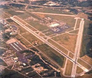
Description: Roslyn Air Base
The following information was provided by MgSgt Jan Klebukowski, 213th Education and Training Manager
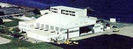
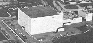
Roslyn ANG station was once a part of the 230 acre estate of Clarence Mackay. The property's first military use came during World War II, when the U.S. Government leased part of the estate as an Air Defense Post of the First Fighter Command. Later, from 1948 until 1959, the site was the home of the 26th Air Division's Air Defense Control Center - which controlled the entire Northeast. During this period it was known as the Roslyn Air Force Station. Formal title to the site changed hands in 1953, when the U.S. Government paid the sum of $250,000 for the current 50 acres. The station was owned by the USAF until the year 2000, when the land was turned over to the local community as a result of the 1995 Base Realigment and Closure commission (BRAC), and the remaining units will be relocated. Since 1959 New York State had a lease on the station for its use as a Communications and Electronics Training site for the Air National Guard. Perhaps the largest and finest non-flying station in the ANG, Roslyn had over 30 buildings, including a Vehicle Maintenance shop, AGE Shop, warehouse, and dining hall. In it's heyday, living space was maintained for as many as 80 people in private and semi-private rooms.
History of Roslyn ANG Station - 1920 to Present
History
Roslyn ANG station was once a part of the 230 acre estate of Clarence Mackay, a millionaire contemporary of the Morgans, Vanderbilts, and Witneys. At it's peak, the estate employed 400 people and entertained such royal visitors as the Duke of Windsor (then Prince of Wales). Charles Lindburgh was also honored here upon his return from Europe in 1927.
During the 1920's and 30's, the estate was the scene of many fabulous society parties and was one of the famed North Shore areas of activity. This era ended with Mr. Mackay's death in 1938 and the subsequent destruction of the main house by fire a few years later.
The property's first military use came during World War II, when the U.S. Government leased part of the estate as an Air Defense Post of the First Fighter Command. Later, from 1948 until 1959, the site was the home of the 26th Air Division's Air Defense Control Center - which controlled the entire Northeast. During this period it was known as the Roslyn Air Force Station.
Formal title to the site changed hands in 1953, when the U.S. Government paid the sum of $250,000 for the 50 acres we now occupy, which today has a replacement value in the millions of dollars. The station is currently owned by the USAF until the year 2000, when the land will be turned over to the local community as a result of the 1995 Base Realigment and Closure commission (BRAC), and the remaining units will move up to Stewart ANGB, Newburgh, New York. Since 1959 New York State has had a lease on the station for its present use - as a Communications and Electronics Training site for the Air National Guard.
Perhaps the largest and finest non-flying station in the ANG, Roslyn has over 30 buildings, including a Vehicle Maintenance shop, AGE Shop, warehouse, and dining hall. In it's heyday, living space was maintained for as many as 80 people in private and semi-private rooms.
Timeline
|-------------------|-------------------|------------------------
1940 - 1948 1948 - 1959 1959 - Present
Air defense Post 26th Air Defense Div 213th EIS, 274th
First Fighter Command
Unit Mission
1940 - 1947 - Air Defense Post, First Fighter Command
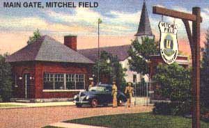
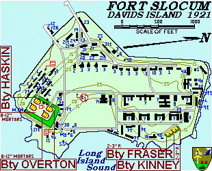
The Fighter Control Center, who was a part of the Army Signal Corps, was used to provide an integrated command and control facility dedicated solely to air defense. The first military buildings consisted of nine buildings, including enlisted and officer quarters, mess hall, recreation building, store room, transmitter building, receiver station, and radio tower, and D/F homer station. Prior to April 1944, access roads, 7 foot barbed wire perimeter fence, Fighter Control Center (currently Building 6), emergency power building, and power distribution system had been completed. At this time, the installation was called the Roslyn Filter Center under the jurisdiction of the 1st Fighter Command. The mission of the Fighter Control Center was detection, interception, identification, and if necessary, destruction of all aircraft in the greater New York Metropolitan area. The mission was centered around the Fighter Control Center, a bomb and gas proof building constructed as the air defense command and control center. Through the use of radar and ground observers, the controllers of the Fighter Control Center would identify and classify all aircraft operating in the region. Unknown aircraft would be targeted for interception, and destruction if necessary, by interceptors operating out of nearby military airfields such as Mitchel Field, or by other active defense systems, such as anti-aircraft artillery (AAA), barrage balloons, and smoke generated equipment situated around nearby defense plants and military installations. Orders to passive defensive systems such as blackouts and air raid warnings were also issued from the from the Fighter Control Center to the appropriate Civil Defense personnel. The Roslyn Filter Center operated until the end of the war and was then declared surplus to the needs of the Air Defense Command. Operating personnel were withdrawn on or about 14 Jan 46., and caretaker personnel were assigned to protect the property against pilfering and vandalism.
"Caretaker" Squadrons stationed at Roslyn Station after the 1st Fighter Command was inactivated on 21 Mar 46 and disbanded on 8 Oct 48
916th Army Air Forces Base Unit
Stationed: 31 Jul 47 - 30 Sep 47 - First "Caretaker" unit on base after 1st Fighter command was disbanded. Unit was based out of Ft. Slocum
Mission: Maintaining and developing Roslyn Control Center.
503rd Aircraft Control and Warning Group
Stationed: 30 Apr 48 - 6 Feb 52
Mission: To develop an Aircraft control and warning system to serve as a link in overall system of Air Defense Command
Footnote: This unit was later absorbed into the 26th Air Division (Defense) on 6 Feb 52 along with the 645th Aircraft Control and Warning Squadron.
645th Aircraft Control and Warning Squadron
Stationed: 30 Apr 48 - 22 Mar 49 and 8 Dec 49 - 6 Feb 52
Primary Mission: Establish a control center at Roslyn for Air Defense units in the surrounding area.
Secondary Mission: Perform Housekeeping functions for the 503rd.
646th Aircraft Control and Warning Squadron
Stationed: 30 Apr 48 - 8 Dec 49
Footnote: This unit was manned by one officer and two airmen at the Roslyn Location
672nd Aircraft Control and Warning Squadron
Stationed: 28 Mar 49 - 1 Apr 49
*Detachment 1 - 19 Apr 49 - 19 May 49
*Detachment 2 - 19 Apr 49 - 10 Jun 49
*Detachment 3 - 19 Apr 49 - 19 May 49
647th Aircraft Control and Warning Squadron
Stationed: 30 Apr 49 - Apr 58(?)
1948 - 1959 - 26th Air Defense Division
Commanded by Brig Gen. Thayer S. Olds, the 26th Air Division was activated at Mitchel Field during the spring of 1949 for later transfer to Roslyn. It's headquarters was located at Roslyn Air Force Station, Long Island, New York, a few miles outside New York City. The mission of the 26th Air Defense Division was to defend the sector of the United States which included all of Massachusetts, Connecticut, Rhode Island, New Jersey, and parts of New York, Pennsylvania, and Delaware. To carry out this mission, NIKE missiles and anti-aircraft guns of the Army, radar picket ships and aircraft of the Navy, and all the tactical units of the 26th Air Division (Defense) of the Air Force were placed under the commander's operational control. The 26th Air Division Defense was transferred to Roslyn on 18 Apr 49, and moved out in February 1959.
U.S. Army 1st NIKE Missile Battalion
Roslyn apparently served as an early Control Center which received radar data from the Montauk Air Force Station in the late 1940s and early 1950s. Also served as Headquarters, HHB 1st Battalion 244th Anit-Aircraft Regiment, New York Army National Guard from 1959 to 1974. For more information on the NIKE programs see http://alpha.fdu.edu/~bender/nike.html and http://www.jps.net/ethelen/
1959 - Present - 213th Engineering Installation squadron, 274th Combat Communications Squadron, 106th Civil Engineering Squadron (Deactivated - October 1995, Absorbed into the 213th EIS), 152nd Tactical Control Group (Moved to Syracuse, New York ), 552nd Air Force Band (Relocated to Stewart International Airport, Newburgh, NY-May 1986)
213th Engineering Squadron
History - The 213th Engineering Installation Squadron has been at Roslyn since 1959, when it moved from a Brooklyn, NY Armory. Its mission install and maintain Radio, Central Office, and Wire communications Facilities. The 213th was federally recognized in 1948 as the 602nd Signal Construction Company, and became the 213th Communications Constructions Squadron, and a member of the Air Force Team in 1952. In January 1959 the unit was redesignated as the 213th Ground Electronics Engineering Installation Agency (GEEIA), and on 1 May 70, the 213th received its present designation as the 213th EI Squadron, a member of the Air Force Communications Service.
Mission - The 213th Engineering Installation Squadron provides for the engineering, Installation, and removal, and relocation of ground communication-electronics systems, and to provide for emergency and programmed, mobile, on-site, maintenance and modification of these systems. The unit also responds to National Guard Bureau taskings.
274th Combat Communications Squadron
History - The unit was federally recognized as the 102nd Communications Squadron in 1948 in White Plains, NY, redesignated as the to the 274th Communications Squadron in 1953 and in 1976 to Combat Communications Squadron in Air Force Communications service as the Gaining Command Plans for utility in a National Emergency. The 274th Combat Communications moved here in 1959.
The 274th Combat Communications Squadron is part of the 253rd Mobile Communications Group which is located in Wellesley, Mass; other units of the group are located in Pennsylvania , District of Columbia, and Maine.
Mission - The 274th Combat Communications Squadron will attain optimum capabilities to install, operate, and maintain mobile communications facilities in support of the 253rd Combat Communications Group and Air Force Communications Service and Tactical Air Command communications area in a national emergency.
552nd Air Force Band
History - The 552nd Air Force Band was activated on August 16, 1942 at Pueblo Army Air Base, Colorado, as the 52nd Army Air Forces Band. The unit was later re-designated as the 552nd Army Air Forces Band in March 1944. A year later, the unit was transferred to an overseas assignment Casablanca, French Morocco, North Africa, assigned to the Air Transport Command. The unit remained in Africa until April 10th, 1946, when it was inactivated and it's personnel were transferred or absorbed into other units. The 552nd Army Air Forces Band was allotted to the New York State Air National Guard in May 1946 with an authorized strength of 29. In September 1947 the band was redesignated 552nd Air Force Band with an assignment station at the State Armory in White Plains, New York.
The band was ordered to active duty during the Korean Conflict on March 24th 1951 and assigned to the 15th Air Force of the Strategic Air Command at March Air Force Base, California. On December 1, 1952, after 21months of active duty, the band was relieved from active military service and returned to the State of New York in an inactive status. In 1954, the band was again reformed and reassigned to Westchester County Airport as a New York Air National Guard contingent. The band operated from the State Armory in White Plains and the Dean Street Armory in Brooklyn until 1959 where it relocated to Roslyn Air National Guard Station in Roslyn, Long Island. While stationed at Roslyn Air National Guard Station, the 552nd performed such historic events such as the 1961 departure ceremonies at Hancock Field in Syracuse, New York; for the federal activation of NYANG forces being sent to Berlin, Germany; the opening ceremony of the lower level of the George Washington Bridge in August 1962; the New York State Winter Olympics at Lake Placid; and the New York City Marathon.
In May 1986, the 552nd Air Force Band was relocated to Stewart International Airport, Newburgh, New York.
The band was manned almost entirely with professional musicians and is considered one of the finest military marching bands in the country. It was very much in demand; performing several dozen times each year. They have played for the President of the United States, the Governor of New York, and for many other distinguished persons.
Mission - The 552nd Air Force Band will support all ANG Bases located within the assigned geographical area without regard to command affiliation. They participate in, and provide music for: Military Formation and Ceremonies; provide musical support for recreation and entertainment programs at ANG installations; provide musical support for the ANG procurement programs; provide musical support for the ANG community relations programs. Additionally, they furnish support to the medical services requirements of military units when an emergency arises.
152nd Tactical Control Group
History - The 152nd Tactical Control Group had originally been a Aircraft Control and Warning Squadron, but had been redesignated as the 64th Air Division, and in August 1953 changed it's designation and mission to 152nd Tactical Control Group and changed its mission to Tactical Control. - Unit moved to Roslyn in 1959. Roslyn was the Headquarters for the 152nd, whose history includes active duty during the Korean War and the 1961-62 Berlin Crisis. The 152nd commands ten Tactical Control Units based in seven states.
The 152nd was federally recognized in March 1948 at White Plains, NY as the 152nd Aircraft Control and Warning Group. The unit saw its first active duty in 1951-53 installing the initial radar systems in Labrador, NewFoundland, and in Greenland.
Following the northern assignment, the unit became a Tactical Control Group with a mission to control aircraft in battle missions against enemy ground and air forces. For the next few years its large organization included subordinate units in Georgia and Puerto Rico. It moved to Roslyn in 1959, and was stationed here when the next federal call up came in 1961. The unit was later relocated to Syracuse ANG Base, New York.
During the height of the 1961-1962 Berlin crisis, President John F. Kennedy visited members of the 152nd Tactical Control Group at the Roslyn Air National Guard Station, New York.
The 152nd deployed its 2,000 officers and airmen to West Germany for ten months of active service with US Forces there. The unit's radar and communications equipment became, for that period, a part of the NATO team.
Mission - Assigned to the Tactical Air Command, the mission of the 152nd Tactical Control Group is to command, organize, equip, and administer the assigned elements of the TACS. This includes radar, Communication equipment, vehicles and support services required to provide the capability to control tactical air operations, including air defense and provide the air space management in a tactical theater of operations any place in the world. Composed of nine units in seven states, the mobile personnel and equipment units are tasked for world-wide deployment in support of joint American and/or Allied nation forces.
106th Civil Engineering - Operation Location
The 106 CE-OL arrived on station in 1984. Prior to it's arrival, the 152nd Tactical Control Squadron provided the function of the host unit. The Mission of the 106CE-OL is to provide daily engineering support and host unit functions to the station. It's military mission is to provide civil engineering service and support on a world-wide basis. The 106CE-OL does not possess heavy equipment but obtains these assets as necessary, from it's parent organization, the 106th Civil Engineering Squadron, location at Westhampton Beach, New York. Due to recent manning cuts, the 106CE-OL was disbanded in October 1995, and it's personnel moved to the Westhampton location, or absorbed onto the 213th EIS.
Memo for Record
Roslyn ANG Station’s Community Support of the Village of East Hills and Roslyn
April 1968 – The 152nd TCC made an emergency power unit available to the Village of East Hills, Long Island, NY and thereby helped avert what might otherwise have resulted in suspension of Village operations in the emergency.
November 1968 – Roslyn ANG Station once again provided an emergency generator to the East Hills Village Hall and offices, which enabled them to stay in operation. In addition, the station Dining hall and other Roslyn ANG Station facilities were made available to the local residences during the evenings and arrangements were completed for the local populace to sleep in the Station recreation hall in the event of a severe cold. Mayor Fleischer wrote a letter to Col Saul expressing his deepest appreciation for the Station’s quick response.
January 1974 – Roslyn ANG Station assists the Town of North Hempstead during a major power outage
May 1975 – Members of Roslyn ANG Station participate in the annual Memorial Day Parade held at Roslyn
March 1976 – Members of Roslyn ANG Station participated as Color Guard for the Roslyn Public School for the nation’s Bicentennial celebration.
January 1978 – Roslyn ANG Station was once again opened to the local community of East Hills, NY after Mayor William Fleischer declares an emergency at 1630hrs on 15 Jan 78. The station was opened to provide local shelter for the local civilian personnel who did not have any heat or electricity due to the ice storm. The emergency ended at 1600 hrs , 18 Jan 78
Jun 1979 – Two members of Roslyn ANG Station assisted local Old Westbury Police at a serious auto accident at Glen Cove Rd and the North Service Rd of the LIE on Saturday, 23 Jun 79 at approximately 0715 hrs.
February 1984 – Members of Roslyn ANG Station assisted the Roslyn Heights Elementary School, Parent-Teacher Association in erecting a self-help playground for the local children. Old tires and telephone poles donated by LILCO were used in the construction.
November 1987 – Mayor Leonard Nadel of the Village of East Hills, NY wrote a letter of appreciation concerning Roslyn’s overall participation in local events and assisting the community over the years.
1991 – Unit assisted Village of East Hills to remove roadway debris after a serious storm.
1993 – Unit assisted local community of East Hills by completing a construction of a Little League baseball Field.
County: Nassau County
City, State: East Hills, Long Island, New York
Royal Blockhouse
Description: Royal Blockhouse: 1759, Oneida County, Town of Sylvan Beach. Wood Creek at Eastern end of Lake Oneida. Two story blockhouse with third story watch tower. Surrounded by large earthworks. Abandoned about 1764. Same as Verona Royal Blockhouse entry.
[Description of image]
Sketch of the blockhouse at the east of Oneida Lake.
County: Oneida County
City, State: Sylvan Beach, New York
Royal, Magazin'
Description: Royal Magazin': 1719, Niagara County. Another name for Joncaire's Blockhouseor Fort Joncaire.
County: Niagara County
City, State: Niagara Falls, New York
Sacandaga Blockhouse
Description: Sacandaga Blockhouse: 1777, Fulton County, Mayfield. Sometimes referred to as Mayfield Fort it was built 20 miles north of the Mohawk, just off Van Den Burgh Road close to the southwestern shore of present day man-made Sacandaga Lake (Sacandaga River). Accounts vary and it was either attacked and destroyed in June 1778 or attacked and not destroyed in April 1780. Shown is the only historical marker found in Mayfield.
[Description of image]
Site of Romeyn's Mill
Erected 1773 by Sir William
Johnson. Burned during
Revolution. Rebuilt by Col.
Abraham Romeyn, commander
Montgomery County Militia.
County: Fulton County
City, State: Mayfield, New York
Sacketts Harbor Forts
Description: Sacketts Harbor Forts: 1812-1815, Jefferson County, Sacketts Harbor. Hastily prepared earthen works named Fort Volunteer were established at the start of the War of 1812 to defend the Northeast end of Sackets Harbor (East side of Black River Bay). A new set of breastworks and a blockhouse named Fort Pike was constructed adjacent followed by a string of fortifications defended the land side approach named Forts Kentucky, Virginia, Chauncey, and Stark. Also Fort Tompkins was on Lake Ontario at the lands end of Navy Point. Later, Volunteer and Pike became the nucleus of Madison Barracks. Proposed to become a village park in the near future.
County: Jefferson County
City, State: Sacketts Harbor, New York
Sag Harbor Fort
Description: Sag Harbor Fort: 1776, Suffolk County, Sag Harbor. The British occupied Sag Harbor in 1776 (it was, next to NYC, the most important port in the province). The British established a major depot and arsenal for supplies on Long Island. An American raid May 1777 destroyed the supplies and captured 90 prisoners. No mention is made as to fortifications. 1813 garrison of 3,000 American soldiers, battle of Sag Harbor. Remained in use as an installation into the 1860s ? (per a drawing of the Suffolk Guard which existed in 1839).
[Description of image]
Sag Harbor, 1861
Suffolk Guard
NYS Artillery
County: Suffolk County
City, State: Sag Harbor, New York
SAGE (Semiautomatic Ground Environment System)
Description: Sage(Semiautomatic Ground Environment System). : 1957-1980? An Air Defense electronic air-surveillance and weapons control system. Data-processing center evaluated and developed information into an air situation and issued weapons guidance orders. Initially it provided guidance for manned interceptors, and was later modified to work with the BOMARC missle. The computer had 50 display consoles for a football field sized computer with 60,000 vacume tubes (now about 256k). The SAGE Direction Center building contained power generation and computing equipment, operational area (over 100 staff), office and maintenance facilities. There were about thirty centers throughout the US and each center was responsible for a sector. The Direction Center for the Boston Sector (Maine to NYC) was at Stewart AFB (BOMARC at Suffolk) and the ___ Sector (Maine to ?Chicago) was at Hancock Field AFB (BOMARC at Niagara Falls).
County: Orange County
City, State: Newburgh, New York
Sailor's Battery
Description: Sailor's Battery: 1812-17, Erie County, Buffalo. South side of Conjaquadie's Creek near its mouth with the Niagara River. A Battery of three 32 pounders. Last in a line of 8 Batteries from the Terrace to the Creek. To the South was Swift's Battery.
County: Erie County
City, State: Buffalo, New York
Salem, Fort
Description: Fort Salem Town of Salem: Washington County, 1777. Also known as White Creek Fort for White Creek and one of the Village's original names. Also referred to as Fort Williams in some accounts, but this likely belonged to another site (see Fort Williams). Also called Number 5. The partially completed New England (Presbyterian) church was converted into a fort by addition of a picket wall, 26 July 1777. The stockade was about 60 feet from the church and constructed from 10 inch diameter 12 to 13 foot sections of an old log meeting house, the balance of the logs went for a blockhouse (see Fort Williams). The area about the fort was also referred to as Fort Edward green. Garrisoned by Cpt. (Col) McCraken's Militia Company (White Creek Militia), of Col. Webster's Regiment. The Militia had left the Town and most citizens had left due to the advance of Bugoyne, when royalists/tories burned the fort between the end of August to 25 September 1777. Plaque reads "Site of The White Creek Fort, Erected as a Presbyterian Church in 1774 and converted to a fort early in the Revolution, Garrisoned by Charlotte County Militia under Command of Col. Joseph McCraken, it was the starting point of many raids on the supply lines of Gen. Burgoyne during the invasion from the North, destroyed by tories and British in 1777."
Thanks to William A. Cormier, Town Historian, for this information, www.sover.net/~salemny/histh1.html
County: Washington County
City, State: Salem, New York
Salonga (Slonga), Fort
Description: Fort Salonga: 1776-81, Suffolk, Fort Salonga. (Slongo) British earthen fortification (minor redoubt). Destroyed by American raid October 1781. Now on private property, bordering Route 25A east of Bread and Cheese Hollow Road in Fort Salonga.
County: Suffolk County
City, State: Fort Salonga, New York
Salt Battery
Description: Salt Battery: War of 1812, Niagara County, Village of Youngstown. An impromptu battery to protect the Village docks, constructed of 400 barrels of salt.
County: Niagara County
City, State: Youngstown, New York
Salt Point Blockhouse
Description: Salt Point Blockhouse: 1795, Onondaga County, N. Syracuse. Salt Point bluff is near bridge over Oswego Canal, and Route 81 and Hiawatha Blvd. Blockhouse was 20 foot high building with loopholes, surrounded by a 20 foot palisade. Demolished in 1816.
County: Onondaga County
City, State: Syracuse, New York
Sampson Army Airfield
Description: Sampson Army Airfield: The Air Force spent about $6 million on renovations and beginning mid Feb 1951 started traing what would be 16,000 Air Force recruits. The base employed about 700 civilians and had 600 permanent party troops. The Base was closed in June 1955. Starting in 1957 to 1960 the Air Field and some Officer Housing on the lake shore (449 acres) were transferred to the Seneca Army Depot, the hospital, now listed as 1,000-beds was transferred to Willard State Hospital (dated 9 Sep 1958 and filed 24 June 67), and 1265 acres of the Station were sold to NYS for park use 7 June 1960 (two parcels totaling 355 acres were auctioned to private individuals). One of the old rifle ranges is still used by the Town Police.
The Station was used by NYS for use as a temporary college for 15,000 GI Bill students in July 1946. (5 barracks were moved to Hobart in Geneva, 7 were moved to Syracuse University) Sampson College operated from September 1946 to June 1949 and had matriculated 7,500 students of which 950 received two-year degrees.
In March 1950 Sampson was proposed to be a State Park, but by October it was determined that the Air Force wanted it for training. The Center was transferred to the Air Force, for use as an indoctination center similar to Lackland AFB in San Antonio. Willard vacated the hospital area.
Sampson State School. The former hospital area was operated as a State School by Willard. In 1971 the State closed the School due to budget cuts. While empty a fire destroyed most of the main hospital complex. Contaminated by asbestos the site was cleaned and is still owned by the Department of mental Hygiene but remains vacant.
County: Seneca County
City, State: Geneva, New York
Sampson Naval Hospital
Description: Sampson Naval Hospital: The Station included a 1,000-bed hospital, housing for personnel, and a school to train corpsmen. Thirty one-story ward buildings comprised the main hospital with additional special services buildings, quarters for officers and nurses, a recreation building and barracks for corpsmen. (reports vary from a typical 100 bed hospital, constructed as a 1,000-bed hospital and often listed as a 2,500-bed hospital). The 1,000-bed hospital, with about 900 TB patients, transferred to the VA at the close of 1946. This was known as area Q, a 466 acre reservation of 141 buildings. On 1 July 1946 the hospital was closed due to budget cuts. In October 1946 the hospital was transferred to Willard State Hospital.
County: Seneca County
City, State: Sampson, New York
Sampson Naval Training Base
Description: Sampson Naval Training Base: On 13 May 1942 construction was announced for a second military installation in Seneca County, on the east shore of Seneca Lake, close to the Army Ordnance Depot (1941 - later Seneca Army Depot). The Station finally covered 2535 acres and was completed in 270 days at a cost of approximately $56 million. The Station occupied about four and one-half miles of lakefront. About 4-5,000 Navy personnel operated and maintained the Station. A total of 411,429 Naval Recruits were trained there during the three and one-half years of operation. Each station unit, to train 5000 recruits, was developed around a parade ground and drill field of 14 acres, adjoined by a drill hall with a two acre indoor drill area, gymnasium, swimming pool, movable stage and motion picture equipment. Living and administrative areas included a mess hall to serve meals cafeteria style, twenty-two barracks to house 228 men each, two barracks for Chief Petty Officers, two dispensaries, a ship service building for recreation, an administrative building, rifle range, small arms magazine and a large storehouse. Sampson had five such Units (six had been planned). Units were named Dewey, Callighan, Farragut, Gilmore, and Edwards. A central group of buildings provided recreational needs for the Station as a whole and included; a large 2,700 seat auditorium, a reception/visitors building, a 400 seat chapel, a CPO Recreation building, a central administration building, receiving building, post office, brig, disciplinary barracks, and guard barracks. There was also a special group of buildings for trainees awaiting assignment after completion of training. On 15 September 1945 Sampson was opened as a separation center, by the beginning of October, three of the five recruit-training sections were closed, and its training career ended 1 November. The Separation Center planned to discharge 100 men daily but was averaging 300 to 400 daily. By the end of October 13,000 had been processed. The 65,00th discharge was on 25 March 1946. The last discharge was early April 46 and the Center was closed.
County: Seneca County
City, State: Geneva, New York
Sanborn (NF-16) Nike Base
Description: Sanborn (NF-16) Nike Base: Mid 1950s-Mid 1960s, Integrated Fire Control Area for Nike-Ajax Missiles, associated launcher area was Cambria
See Nike for more information.
County: Niagara County
City, State: Niagara Falls, New York
Saraghtoga, Fort
Description: Fort Saraghtoga: 1704, Washington County, Town of Easton. 150 feet long by 140 feet wide to house 450 troops. Had six 12 pounders and six 18 pounders. Located on East side of Hudson River opposite Fort Saratoga. Demolished in 1713.
County: Washington County
City, State: Easton, New York
Saratoga Battle Forts
Description: Saratoga Battle Forts: For details see Fort Neilson, Balcarres Redoubt, Breymann Redoubt, and Great Redoubt.
For more information see: www.cyhaus.com/usroute4/ (link opens new window)
County: Saratoga County
City, State: Saratoga, New York
Saratoga, Fort
Description: Fort Saratoga: 1702, Saratoga County, Schuylerville. Built on the Hudson River South of Fish Kill (Creek) South of present day Schuylerville, by Col. Schuyler during the Nicholson Expedition as a supply post. Site of previous blockhouse (Fort Vrooman 1689) for the Winthrop Expedition. A stockaded fort was proposed in 1702 to be manned by a Lt. and 30 men. Rebuilt 1721 by Phillip Livingston. Destroyed Nov 1744 by 400 French and 200 Indians that plundered down to outskirts of Albany. Rebuilt in 1746 as Fort Clinton (1).
[Description of image]
Site of
Fort Vrooman 1689,
Fort Saratoga 1702
rebuilt by Philip Livingston 1721,
Fort Clinton 1746
rebuilt and named for Govenor
County: Saratoga County
City, State: Schuylerville, New York
Schenectady Service Force Depot
Description: 1918, Schenectady County, Rotterdam. The depot was constructed in 1918 and served the Army during the later months of WW1. After the war it was used as a supply depot for 55 Civilian Conservation Corps Camps. In 1941 the depot was expanded and renamed Service Forces Depot. Mostly the depot shipped motor vehicles to the Port of New York. At its peak it employed 4000 people. Late in WW2 it was renamed again to General Depot. From January 1948 to March 1949 it was a processing station for war dead. In the post war years it was again renamed Army Depot. Expanded again during the Korean War. The depot continued operations for a number of years after Korea and then was closed.
County: Schenectady County
City, State: Rotterdam, New York
Schenectady Stockade
Description: Schenectady Stockade (1): (Schenectida) 1672 received patent. The village was divided into four blocks, or squares, and these were subdivided into house-lots. The entire area of the village was enclosed and fortified with stockades, or palisades. It was patented as a township with certain municipal rights in 1684. At various times in its early history, Schenectady suffered from the attacks of the French and the Indians. The most memorable of these attacks known as "The Massacre of Schenectady". was in February, 1690. Schenectady is said to have had at this time about 80 houses and 400 inhabitants, of which 60 were killed, 27 made prisoners, and the village burned. The village was protected by palisades. There were two gates, one at the north end of Church street, the other at the south end, opening out to the Albany road. There was, also, near what is now the corner of Washington and Front streets, a fort garrisoned by 24 men.
Schenectady Stockade (2):1690, Schenectady County, Schenectady. After the destruction of this stockade, another one was built immediately that served until a new fort was built about 1705 at the opposite corner where now is the junction of Front, Ferry, and Green streets, named Queen's Fort in 1705 and also known as Royal Fort.
Schenectady Stockade (3):1735, Schenectady County, Schenectady. A new stockade was erected in 1735. A parallelogram from present N. Street near the river, south to the vicinity of Schenectady County Community College, east along State Street to Rail Road, then north from Wall Street to the start. A new fort, also known as Corlear's Fort and in 1754 known as Fort Cosby was built of heavy wooden timbers set on a stone wall. This was almost 12 feet high and 100 feet to a side. In 1776 referred to as Fort Schenectady, with Continental Army Troop Barracks. Later maps showed a stockade with numerous blockhouses in addition to the fort. The third stockade and fort were demolished about 1783.
County: Schenectady County
City, State: Schenectady, New York
Schlosser, Fort
Description: Fort Schlosser: 1760, Niagara County, Niagara Falls. Built 40 rods further upstream from the site the French Fort Little Niagara or Fort du Portage (1750-9) at the head of the Niagara Falls Rapids and south (upper) end of the land route from Fort Niagara. The new fortifications were a ditched square earthworks fort with four bastions. The chimney from the burned French fort was used for the new barracks and mess house. The British also established a shipyard on Navy Island in the river opposite the Fort. The portage route was attacked frequently and in September 1763 was the "Devils Hole Massacre". Based on that 11 (or 5 by another account) blockhouses were constructed on the route for shelter in 1764. It remained occupied by the British during the Revolutionary War and American operations never got to that area. Vacated in 1796. Garrisoned by American troops in the War of 1812 it was captured in December 1813 and burned, although another account says it was maintained until 1857 when it burned. The stone chimney was still there in 1980.
County: Niagara County
City, State: Niagara Falls, New York
Schroeppel Fort
Description: Town of Schroeppel Fort: 1758-59, Oswego County, Town of Schroeppel. A stockaded fort about 60 feet square with three storehouses. Site on NY Route 57 at Three Rivers.
County: Oswego Cunty
City, State: Schroeppel, New York
Schuyler, Fort
Description: Fort Schuyler (1): 1709, Washington County, Village of Fort Ann. Built by Col. Nicholson in his advance against the French (Nicholson Expedition), in The Queen Anne's War, named in honor of Col. Peter Schuyler, destroyed in retreat to Albany. Rebuilt in 1711 as Queen's Fort, renamed Fort Anne.
Fort Schuyler (2): 1775, Oneida County, Utica. Revolutionary War, not to be confused with Fort Stanwix in Rome.
Fort Schuyler (3): 1776, Oneida County, Rome. Name also used by Americans for Fort Stanwix during the Revolutionary War.
Fort Schuyler (4): 1833-1911, Bronx County, Throngs Neck. A tract of 52 acres was purchased by the Federal Government from William Bayard in 1826 and construction of the fort began in 1833. This was intended to close the western end of the Sound and thus protect New York from attack by sea from this direction. Originally a companion to Fort Totten on the opposite shore. In December 1845, the fort was ready for its armament of 312 seacoast and garrison guns, six field pieces and 134 heavy guns. The installation of the armament was completed in 1856, and the fortification was named Fort Schuyler, in honor of General Philip Schuyler. The fort was built of granite brought from Greenwich, Conn., in an irregular pentagon, and was built to accommodate a garrison of 1,250 men. Three full bastions at the salients of the waterfront, two demibastions flanking the gorge on the land front, and the bastioned coverface and covered way protecting the land side were armed for firing from every angle. The fort had two tiers of guns in casemates and one en barbette. The casemates had two embrasures each. Two gun embrasures and one howitzer embrasure were closed later on to make room for a torpedo casemate. On the land side, approach was over a drawbridge, after the manner of a medieval castle. This opened into a tunnel with narrow slits in each side for riflemen who thus would be able to pour a heavy fire upon any attacking force from that quarter. In 1864 was used for 500 Confederate POWs. In 1868 ten Rodman guns were mounted in casemates of the first tier and these in turn were replaced later by eight-inch rifles. Construction of modern defenses was begun in 1896. Under this program two ten-inch and two twelve-inch guns on disappearing carriages; two five-inch rapid fire guns, two fifteen-pounders and battery commanders' stations for the ten-inch and twelve-inch batteries were installed. After October 12, 1870, the post stood abandoned; but three years later work was begun on widening the terreplein of the north and east waterfronts for barbette batteries of fifteen-inch guns, leaving the emplacements unchanged on the south front and the demibastions of the gorge. This work was suspended in 1875 for the want of funds. Batteries in 1921 were as follows;
Battery Gansevoort, 1 - 12" Disappearing (1 empl vacant)
Battery Hazzard, 2 - 10" Disappearing
Battery Bell, 2 - 5" Pedestal
Battery Beecher, 2 - 15 pdr
AA, 2- 3".
For more information see Coastal Defense Study Group (link opens new window)
Marginal use continued until 1911 when it was closed. Most of its guns were stripped for scrap during WW1. In 1931 the site was leased for the NYS Merchant Marine Academy. Now part of New York's Maritime College (SUNY), with several of the original casements renovated into a library.
For more information see www.maritimeindustrymuseum.org/schuyler.htm (link opens new window)
County: 1) Washington County, 2) Oneida County, 3) Oneida County, 4) Bronx County
City, State: 1) Fort Ann, New York, 2) Utica, New York, 3) Rome, New York, 4) Throgs Neck, New York
Schuyler's Supply Depot
Description: Schuyler's Supply Depot: 1777, Saratoga County, Stillwater. Built on or near previous forts and barracks (Ingoldsby 1709, Winslow 1756, Montressor 1758), General Phillip Schuyler built fortified supply depot in preparation for Burgoyne's advance.
[Description of image]
Historic Sites
Fort Ingoldsby built 1709
Fort Winslow built 1756
Montressor's Blockhouse &
Storehouse Barracks 1758
Schuylers Supply Depot 1777
County: Saratoga County
City, State: Stillwater, New York
Scotia Naval Supply Depot
Description: Scotia Naval Supply Depot: 1942, Schenectady County, Scotia. The depot was built in 1942-43 as a storage and supply depot for naval forces along the Atlantic coast and Europe. Mostly stored large items such as boilers, turbines and reduction gears. Home of the Navy's Landing Craft Maintenance and Battle Damage Program and the Navy's Automotive and Handling Equipment Spare Parts Program. Employment peaked in 1945 at 2342. In 1947 five storage facilities were improved as permanent storage facilities for large machine tools. During the Korean War home for the Navy's Specifications, Forms and Publication Center. Recently most of the depot has closed and reverted to commercial use. A small Naval Reserve and Surplus Property Operation remains.
County: Schenectady County
City, State: Scotia, New York
Scott, Camp Winfield
Description: Camp Winfield Scott: 1860, Suffolk County, Long Island. Near what later was Camp Black.
County: Suffolk County
City, State: Long Island, New York
Scott, Fort
Description: Fort Scott: 1814, Clinton County, Plattsburgh. One of three redoubts between Saranac River and Lake on Platt's Point, 8 cannon no buildings. Part of Land Battle in Battle of Plattsburgh, War of 1812. See Plattsburgh Battle Forts for story and map.
County: Clinton County
City, State: Plattsburgh, New York
Seneca Army Depot
Description: Senaca Army Depot: 1941, Seneca County, Seneca Falls. Near Sampson Naval Training Center (1942) (now a State Park, except for Officer Row) and the Sampson Army Airfield (1950 former SNTC) (airstrip part of the Depot), and the Naval Hospital (now state property). Major ammunition depot for the East Coast. Started in 1941 as a 11,500 acre ammunition dump with an aviation runway. The North Depot Activity was developed in 1956 and included storage of special weapons for the Griffiss AFB. The special weapons support (north) post was merged with the Depot in 1961 and was vacated upon closure of Griffiss in 1993. Two large GSA warehouses were built in 1953 and 54. The depot is in closure operations since listed to be closed in 1995. Future disposition unknown.
County: Seneca County
City, State: Seneca Falls, New York
Setauket, Fort
Description: Fort Setauket: 1777, Suffolk County, Setauket. Occupied by a Tory Battalion the Presbyterian Church on Strong's Neck Road was fortified. The post was enclosed at a distance of 30 feet with 6 foot high earthworks topped with a palisade of 6 foot pickets. The parapet included interior "steps" for firing positions. American attacks repulsed in August 1777 and December 1777. Abandoned in early 1778. Local citizens restored the church (which later burned and was rebuilt) and removed the earthworks.
County: Suffolk County
City, State: Setauket, New York
Shanks, Camp
Description: Camp Shanks: Jun 1943-July 1946, Rockland County, Orangeburg. Camp Shanks was a large staging area for troops going overseas through the New York ports of embarkation. 1944 had Italian Service Units. Hospital was used for debarkation hospital at the end of the war. After war, used as a staging area for German POW repatriation. Closed and sold after the war.
County: Rockland County
City, State: Orangeburg, New York
Skenesborough, Fort
Description: Fort Skenesborough: 1759, 1775-77, 1812, Washington County, Whitehall. The first structure here was a blockhouse in 1759 with a barracks on a hill to the west of Wood Creek, which still existed in 1775. The site is between the Presbyterian Church and the Masonic Temple. At the start of the Revolutionary War the Americans took Skenesborough (Philip Skene was a Loyalist) and built new fortifications strating in October 1776. This site was also the shipyards for General Arnold's Lake Champlain fleet. Built very near the 1759 site was a barracks and a fortified stockade described as an irregular polygon. Retreating before Burgoyne in July 1777 the Americans attempted to burn the fort. The British repaired and garrisoned the fort along with fortifying Skene's stone barn, for three weeks before continuing on to Saratoga. During the War of 1812 a new blockhouse was constructed within the ruins of the old fort to protect the shipyards.
County: Washington County
City, State: Whitehall, New York
Slocum, Fort
Description: Fort Slocum: 1861, Davids Island (80 acres), near Rye, NY. Named for Major General Henry W. Slocum, hero of Antietam and Chancellorsville. 1861 used as a Medical Facility with 22 temporary structures built to house 1,800 Confederate POWs. After Gettysburg grew to over 2,538 then later used as a Coastal Artillery post.
In 1921 gun emplacements included
Battery Overton, 2 - 12" Mortars
Battery Haskin, 2 - 12" Mortars
Battery Kinney, 2 - 3" Pedestal
Battery Fraser, 2 - 3" Pedestal
AA, 2 - 3"
For more information see Coastal Defense Study Group (http://www.cdsg.org/)
and Fort Slocum ( http://www.home.earthlink.net/~michaelacavanaugh/id1.html) [Links open new windows]
Taken from Joe McCusker's list of Air Force Bases www.airforcebase.net/usaf/joeslist.html [link opens new window]
Slocum AFB, Davids Island, New Rochelle, N.Y. (Headquarters First Air Force was at Ft. Slocum from 1946 until 1949. Ft. Slocum, on an island near New York City and accessible only by ferry boat, was redesignated Slocum AFB in June 1949. Headquarters First Air Force moved to Mitchel AFB four months later. The base was then looked after by the 166-person 2226th Standby Base Squadron, and later by a much smaller fire guard, until June 30, 1950, when the New York District Engineer assumed custody of the property and Slocum AFB ceased to exist. Ft. Slocum was reactivated as an Army post late in 1950, and closed in 1965. Twice swept by fires, the island--which is owned by the City of New Rochelle--has been in ruins for many years.)
The following was contributed by Joseph Tabaco ,TSG, NYANG (Ret):
Established as Northeast Air District on October 19, 1940. Activated on December 18, 1940 at Mitchel Field, New York, assigned to Northeast (later, Eastern) Defense Command, U.S. Army. Redesignated 1st Air Force on April 9, 1941 and First Air Force on September 18, 1942. Assigned to Army Air Forces on September 17, 1943; Continental Air Forces on April 16, 1945; and Air Defense Command on March 21, 1946. Moved to Fort Slocum (later, Slocum AFB), New York, in June 1946. Assigned to Continental Air Command on December 1, 1948. Moved to Mitchel AFB, New York, in October 1949. Discontinued on June 23, 1958. Activated on January 20, 1966, assigned to Air (later, Aerospace) Defense Command, and organized on April 1, 1966, at Stewart AFB, New York. Inactivated on December 31, 1969.
www.maxwell.af.mil/au/afhra/wwwroot/rso/numbered_airforce_index.html [link opens new window]
This is a list of bases that had no useable airfield during the time period they were officially called "Air Force Base."
www.airforcebase.net/usaf/capitalb.html [link opens new window]
NIKE: New York Nike Site NY-15C
USAF: Slocum AFB
This Nike facility, on Davids Island was operational from approximately 1955 - 1960. Fort Slocum transferred from the Army to the Air Force sometime in the late 1940s. It was redesignated Slocum AFB on 10 Jun 1949, and only remained in the Air Force inventory a short time. Disposition after Nike use is unknown.
www.airforcebase.net/usaf/usafnike.html [link opens new window]
From 1951 to 1979 the Chaplain School was situated at four posts in the New York City area: Fort Slocum (1951-1962; Fort Hamilton (1962-1974); Fort Wadsworth (1974-1979); and Fort Monmouth, New Jersey (1979-1995).
www.usachcs.army.mil/HISTORY/SchoolHist/HistorySchool.htm [link opens new window]
Fort Slocum
(1863 - 1928/1965), Davids Island
Located offshore from New Rochelle. Originally built as a military hospital complex and POW camp. Nearby Hart Island was also used. First fortified in 1878. Batteries here were an unnamed 1898 battery, Battery Haskin (1897 - 1919), Battery Overton (1897 - 1919) partially destroyed, Battery Practice (1896 - 1899) partially buried, Battery Kinney (1904 - 1917) destroyed, and Battery Fraser (1901 - 1917) destroyed. Became Slocum Air Force Base (NIKE Missile Base) from 1946 - 1950, and 1955 - 1965, and also used for the Armed Forces Information School, an Army Chaplain School, and a training and recruitment center (1919 - 1946). The island now sits abandoned and overgrown. A 15-inch Rodman cannon sits by the wharf.
www.geocities.com/naforts/nycity2.html [link opens new window]
When doing searches for Ft Slocum, be careful as there is an older Ft Slocum in the DC area
County: Westchester County
City, State: David's Island (near Rye), New York
Smith, Camp
Description: Camp Smith: 1882/5, Westchester County, Peekskill. New York Militia Camp. Original camp grounds acquired in 1885. Known as Camp Townsend in 1898 for the State's Adjutant General during the Spanish-American War mobilizations. Enlarged in 1913 and renamed for Governor Smith, 1914 and 1923 to its present size of nearly 2,000 acres.
[Description of third image]
Camp Smith
New York National Guard
Training camp estabalished
1882. Contains 1900 acres
named for Alfred E. Smith,
Governor of New York.
This brief history has been culled from a series of six articles that ran from February to July 1925 in The New York National Guardsman magazine. The author was LTC William R. Wright.
Part I - Terrian
The present reservation comprises nearly 2,000 acres. It stretches for about two and a half miles along the Hudson River, extending from Peekskill or Annsville Creek on the south to the Putnam County line on the North, and goes back from the river for almost two miles, touching the Albany Post Road (State Route 9) at one point. It formed the northeast corner of the great Cortlandt Manor of Colonial days.
The original camp ground consisting of the west camp and parade grounds extending to the 500 yard butts and excluding the higher ground of the Ordnance and Superintendent’s houses (buildings 89 and 90), was about 150 acres of the McCoy Estate. The state initially leased 97 acres of this site in May 1882. Site improvements were commenced on 6 June 1882, with the first encampment on 1 July 1882. The site was purchased in 1885. With appropriations in 1913 and 1914 the remaining 187 acres of the McCoy farm was purchased, together with smaller parcels aggregating about 65 acres owned by Theodore Wendover and Clifford and Franklin Couch. This carried the property down to the Albany Post Road and the Annsville Road, and provided for a backstop for the present target range. In 1923 the largest addition to the terrain was made by the purchase from the Van Cortlandt Estate of some 1,485 acres, giving the state ownership of all of the hills north of the camp to include Anthony’s nose.
Main historical and geographic points of interest are Anthony’s Nose, Manitou Mountain, the old copper mine, the remains of Revolutionary forts and, of course, the Military Road. Anthony’s Nose rises to an elevation of 900 feet and is one of the best known peaks along the river. See HISTORY OF NAME. A trail leads to its summit from the military road just north of the camp, and this trail and access is part of the Appalachian Trail which crosses the Hudson at the Bear Mountain Bridge and goes North up Route 90. Manitou Mountain, 760 feet high, from which fine views to the west and south can be had. The old copper mine was on Roa Hook opposite the Camp entrance and has probably been destroyed by mining operations, as has the remains of Fort Independence which was also on Roa Hook. The Military Road (Road A) was started in 1891 to connect Garrison (opposite West Point) and the NYS Camp. It was only constructed to slightly north of the Camp by 1897 when funds ran out. See Revolutionary War for forts, etc., in the area.
Part II - Early Usage
1882: The first regular encampments started on 1 July 1882 with the 23rd Infantry of 428 men. The succeeding years were marked by steady improvement in training methods and increasing use of the Camp for that purpose. In 1889 a new mess hall was built, the Military Road started in 1891, the first field problem made its appearance in 1894 to be followed by more elaborate ones to include the regimental "march-out" to Lake Mohegan. This period was marked by conflicting opinions between encampments with marksmanship training, and increasingly more complex maneuvers.
1904: The Manassa maneuvers in 1904 shattered the routine of years. Maneuver training became paramount. Units were scattered for larger maneuver training to Massachusetts, Pine Camp (Fort Drum), Connecticut, and Camp Whitman (Black River - Fort Drum). Peekskill was still used occasionally by 1911 as the minutia of drill and routine following maneuvers, although it was now primarily used as a rifle range for New York City troops and for Officers and non-commissioned officers schools. It was in the old White House (removed 1923) that the council of war of commanding officers was held by Gen O’Ryan prior to the call for the Mexican Border Service.
WWI: In 1917 the 15th NY (presently the 369th) trained at Peekskill [prior to their going to WWI and subsequent glory]. The Camp was also used throughout the war by the 1st Provisional Regiment, NYG, as a post during their services on duty guarding the NYC water supply, and also by the U.S. Navy. During the reconstruction of the New York Guard after the War, and its Federal recognition as the New York National Guard, the Camp played a gradually increasing role. 1920 saw only officer and NCO schools as Regiments were federally recognized and sent to U. S. Army posts for their summer training. 1921 all of the NYC Regiments trained at Camp. 1922 through 1925 all NYNG Infantry units occupied the Camp.
POST WWI: Major improvements were made to the Camp from 1925 through the early 30’s. In 1925 the target ranges were reconstructed in their present locations, the Broccy Creek Reservoir was constructed as was the present sewage plant and incinerator (buildings 65,, 64), the "new" officer’s mess was constructed in 1930 (the present building # 79). In 1931 all of the trails were given names from the sectors in Belgium and Northwestern France, where the Twenty-Seventh Division made a glorious record in the fall of 1918, none of these names are known to be used today.
Part III - Present Usage
1960-70: The next major renovation of the Camp that comprises its current configuration and use occurred in the 1960’s and 70’s. New modern brick barracks and support facilities were constructed in 1964 (501, 506), 1965 (504, 505), 1967 (507, 503), and 1968 (508). In 1973 Baker Hall (502) was constructed to replace the old wooden Post Exchange building from the early 1920s. The USP7FO was relocated from Brooklyn to a new Warehouse (513) in 1973, and an additional building was added in 1984(514). This period continued much as before, with major Annual Training periods being done at major U. S. Army posts and the Camp primarily being used for weekend training and schools. Marksmanship training has taken on a major role here as many indoor ranges at armories were closed in the 1980s due to lead and ventilation problems.
Present: Most recently the Camp has become a more permanent home for numerous activities. The Headquarters 53rd Troop Command occupied building 501 from 1995 until December 1997 when it moved to Valhalla and was replaced on-site in January 1998 by the Headquarters 1st Battalion 53rd Troop Command. The FBI, DEA and Postal are permanent tenants with daily use of the ranges for their marksmanship programs. The Peekskill Warehouse (513) is one of the main full time supply activities for the NYARNG, and full time maintenance activities are conducted at Combined Support Maintenance Shop A and Organizational Maintenance Shops 16 and 20. Recently the Empire State Military Academy, which had been training officers and NCOs since 1920, was reorganized as part of a national effort and redesignated the 106th Regimental Training Institute. The 106th RTI occupies building 48. The 199th Army Band, "The Governor's Own." has long been a presence in building 84, and Company A(-) 1st Bn 105th Infantry (light) is in building 119.
Future: Ongoing work includes major reconstructions of the facility’s antiquated infrastructure, such as water, sewer, and electrical distribution systems. Also in design is a new BOQ to be constructed north of 508. Camp Smith remains a valuable asset for small arms weapons training and military academy and youth training. Recently the National Guard Bureau has classified the camp as a Collective Training Area (CTA) or an official Annual Training (AT) site for Battalion sized units. Due to terrain restrictions the camp caters mainly to Light Infantry, Signal, and Maintenance units. Camp Smith is also a major testing ground in the field of simulations and high tech training.
The Revolutionary War
Peekskill was the center of many military events during the War of the Revolution. It was located at the gateway of the Highlands, which guarded the water communication into the heart of New York State, and also formed part of that mountain barrier, extending to the southwest, behind which Washington so skillfully operated his little army. It was a part of Washington’s "Hindenburg Line," but unlike a certain other well known Hindenburg Line, it was never broken. Driven back at times, the Americans always pushed forward again, and the close of the war found the gateway still firmly in their possession.
The main line of resistance was at first directly on the line of the Manitou. Later it was near West Point, but always the outpost line was either of Peekskill or at Verplanck’s Point, a few miles south.
The forts located in the vicinity were:
British Map
Fort Lafayette, Verplanck’s (Verplancke’s) Point south of Peekskill on the East bank of the Hudson. British landed 22 Mar 1777 in Lents Cove near Peekskill, attacked Peekskill, encounter near Peekskill Creek. September 1777 British landed a force at Peekskill, burned barracks and stores.
Fort Independence, on Roa (or Rahway) Hook, east bank of the Hudson, opposite the entrance to Camp Smith. All trace of this fort was obliterated by the operations of a sand and gravel company in the early 20’s.
Fort Lookout, between Peekskill and Canopus Creeks, east of Camp Smith. In 1925 a clump of dead trees on the hill were inside the old earthen works.
Fort Constitution, On an east bank island opposite West Point.
Fort Stony Point, West bank of Hudson accross from Fort Lafayette. Captured by British, starting point of attack 6 October against Forts Clinton and Montgomery. Later recaptured by "Mad Anthony" Wayne.
Forts Clinton and Montgomery, on west bank of Hudson south and north respecfully of the Popoloen Creek, accross from Anthony’s Nose, now directly adjacent to the Bear Mountain Bridge. British forces under Sir Henry Clinton attacked 6 Oct 1777 American forces Commanded by Generals George and James Clinton. The Americans were defeated, a desperate fight between Lake Sinnipink and the river (rear of Bear Mountain Hotel) gave the lake the name "Bloody Pond."
Fort Putnam, at West Point.
Another Fort Clinton at West Point on the Hudson.
Boom and Chain, accross the river at Fort Montgomery to Anthony’s Nose, about where the Bear Mountain Bridge is now. Capture of Forts Clinton and Montgomery 6 Oct 1777 led to the abandonment of the American fleet and the British breaking through on 7 Oct 1777. The British went upriver as far as Kingston, which they burned. At this time a force was advancing from the North under General Burgoyne, to meet with the British fleet. The defeat and surrender of Burgoyne to General Gates in Saratoga on 17 Oct 1777 ended this threat. Recently a Revolutionary War gun emplacement site has been found near the base of Anthony’s Nose where the boom and chain would have been anchored.
The above is only the barest outlines of the interesting history of the vicinity of Camp Smith during the Revolution. Details may be read in Bolton’s or Scharf’s "History of Westchester County," or Washington Irving’s "Life of Washington."
The above information was extracted from articles by LTC William R. Wright in the Feb, Mar, and April 1925 issues of The New York National Guardsman magazine.
Part 5 - History of a Name: Naming of Anthony's Nose
In the late 1600’s, families soon became identified with certain localities. Washington Irving speaks of the Van Cortlandts of Groatan, or Croton Point, and the Van Grols of Anthony’s Nose. His account of the naming of the latter promontory in honor of Anthony Van Corlear, the town trumpeter of New Amsterdam (New York), is given in his Knickerbocker History of New York. No other reason having been discovered for the title in question we publish his account of the christening with the sole remark "interesting if true."
"It must be known that the nose of Anthony Van Corlear was of very lusty size, strutting boldly from his countenance like a mountain of Golconda, being sumptuously bedecked with rubies and other precious stones, -- the true regalia of a king of good fellows, which jolly Bacchus grants to all who bouse it heartily at the flagon. Now thus it happened, that bright and early in the morning the good Anthony, having washed his burly visage, was leaning over the quarter railing of the galley, contemplating it in the glassy wave below. Just at this moment the illustrious sun, breaking in all its splendor from behind a high bluff of the highlands, did dart one of his most potent beams full on the refulgent nose of the sounder of brass -- the reflection of which shot straightway down, hissing hot, into the water, and killed a mighty sturgeon that was sporting beside the vessel! This huge monster, being with infinite labor hoisted on board, furnished a luxurious repast to all the crew, being accounted of excellent flavor, excepting around the wound, where it smacked a little of brimstone; and this, on my veracity, was the first time sturgeon was eaten in these parts by Christian people. When this astonishing miracle came to be known to Peter Stuyvesant, and that he tasted of the unknown fish, he, as may well be supposed, marvelled exceedingly, and as a monument thereof, he gave the name Anthony’s Nose to a stout promontory in the neighborhood; and it has continued to be called Anthony’s Nose ever since that time."
The above information was extracted an article by LTC William R. Wright in the March 1925 issue of The New York National Guardsman magazine.
County: Westchester County
City, State: Peeksill, New York
South Battery
Description: South Battery: 1810, New York City Harbor defenses. At foot of Bridge Street, foot of Manhattan, probably east of Castle Clinton which was known as South West Battery. This would be Battery Park or what in 1776 was known as the Grand Battery below Fort George.
South Battery (2): 1812, Kings County, Governor's Island. Built to guard Buttermilk Channel between Island and Brooklyn in 1812. On southern tip prior to island's expansion with fill from Brooklyn Tunnel. Later used as an Officer's Club.
County: 1) New York County, 2) Kings County
City, State: 1) New York City, New York, 2) Governor's Island, New York
South Redoubt
Description: South Redoubt: 1778, Putnam County, Village of Garrison, American. As part of the enlarged defenses of West Point two redoubts (North and South) were built two miles southeast of Constitution Island in the highlands enroute to Continental Village. Constructed on two sides of a hill now known as Fort Hill between the Village of Garrison and US Route 9.
County: Putnam County
City, State: Garrison, New York
Southampton Old Fort
Description: Town of Southampton Old Fort: 1777-8, Suffolk County. Site of British fort during occupation.
County: Suffolk County
City, State: Southampton, New York
Sow (Oquaga), Battery Old
Description: Battery Old Sow (Oquaga): 1812-14, Erie County, Buffalo. Near present City Water Plant, earthwork with one 8 inch Mortar. To the North was Fort Tompkins, and to the South was the Gookins Battery.
County: Erie County
City, State: Buffalo, New York
Speed Blockhouse
Description: Speed Blockhouse: 1806, Tompkins County, Town of Caroline (Speedsville). On NY Route 79 - 1 and 1/2 mile west of town.
County: Tompkins County
City, State: Caroline (Speedsville), New York
Spiral Fort
Description: Spiral Fort: : 1776, Kings County, Brooklyn. See Fort Corkscrew.
County: Kings County
City, State: Brooklyn, New York
Spring Valley (NY-99) Nike Base
Description: Spring Valley (NY-99) Nike Base: 1956-63, Integrated Fire Control Area Nike-Ajax Missiles, launcher area was Ramapo. Inactivated 1963. Site owned by East Ramapo School District and is partially intact.
For more information see alpha.fdu.edu/~bender/NY99.html (link opens new window)
County: Rockland County
City, State: Spring Valley, New York
St. Anne, Fort
Description: Fort St. Anne: 1667, Isle La Motta, Lake Champlain, Vermont. French fort.
For more information see www.historiclakes.org/explore/Exploring.html#FORT STE. ANNE (link opens new window)
County: Grand Isle County
City, State: Isle La Motte, Vermont
St. Croix, Fort
Description: Fort St.Croix (1): 1620s, Rensselaer County, West of Town of North Hoosick. Dutch stockade with cannon on North east bank of the Hoosick River. Destroyed some years later.
Fort St. Croix (2): 1750s, Rensselaer County. Built to protect Dutch settlement and guard Houstatonic Valley during French and Indian War.
County: Rensselaer County
City, State: North Hoosick, New York
St. George, Fort
Description: Fort St. George: 1777, Suffolk County, Mastic, Smith's Point. British, 1777-1780, a triangular fort included existing manor houses in two corners and a fortification in the third. Served as British supply base, destroyed in Nov 1780 raid.
County: Suffolk County
City, State: Mastic, New York
St. Theresa, Fort
Description: Fort St. Theresa: 1665, Richelieu River, Quebec, Canada. French fort at head of rapids near Lake Champlain.
County: Quebec County
City, State: Richelieu River, Quebec, Canada
Stanwix, Fort
Description: Fort Stanwix: 1758, Oneida County, Rome. Built in summer 1758 to guard a strategic portage along a major transportation route. Fort Stanwix guarded the centuries old Oneida Carrying Place. This strategic Iroquois Confederacy portage in upstate New York bridged the waterways between the Atlantic Ocean (Hudson - Mohawk) and the Great Lakes (Wood Cr - Oneida Lk, Oswego R.). After the British conquered Canada in 1760 it gradually ceased to be a military post. During the American Revolution (then also known as Fort Schuyler), the Americans rebuilt the ruined fort in the summer of 1776. British military forces were repulsed while attempting to besiege the fort. In this battle of 3 Aug 1777 it is claimed that the Stars and Stripes first flew in the face of the enemy. American militia and Oneida allies tried to come to the aid of Fort Stanwix, but were cut off in an ambush at Oriskany, considered one of the bloodiest engagements of the war. Both these battles were part of St Leger's attempt towards Albany to meet up with Gen Burgoyne who was defeated at Saratoga. In 1781 the fort was virtually destroyed by fire and flood and substantially rebuilt and its original name restored. During the War of 1812 it was seriously neglected and a blockhouse was built as an emergency on the parade ground. Beginning in 1828 the fortifications were gradually dismantled. From 1970 to 1977 the National Park Service reconstructed the fort.
County: Oneida County
City, State: Rome, New York
Star Redoubt
Description: Star Redoubt: 1776, New York City, See Lispenard's Redoubt.
County: New York County
City, State: New York City, New York
Stark, Fort
Description: Fort Stark: 1812-15, Jefferson County, Sackets Harbor. A minor redoubt in a fortified line of 4 such "forts" (Kentucky, Virginia, Chauncey, Stark) anchored at Fort Pike on the Bay (later Madison Barracks) protecting the land side of Sackets Harbor.
County: Jefferson County
City, State: Sackets Harbor, New York
Ste. Frederic, Fort
Description: Fort Ste. Frederic (at Crown Point): 1734/37- 1759, Essex County, Crown Point. Fortifications were started by the French in 1734. Until 1759 Ft. Ste. Frederic was the seat of French power on Lake Champlain. The French destroyed the Redoute of the fort in 1759 before the advancing British. The British occupied the remaining buildings as a Hospital until the construction of Fort Crown Point was completed. Foundations remain, open to public.
County: Essex County
City, State: Crown Point, New York
Ste. Marie Degannentaha
Description: Fort Ste. Marie Degannentaha: 1656, Onondaga County, Onondaga Lake, Syracuse. Constructed in 1656 to protect a French settlement, abandoned about 1658. Current reconstruction based on original Jesuit plans of the French Fort and Stockade.
County: Onondaga County
City, State: Syracuse, Onondaga Lake, New York
Sterling, Fort
Description: Fort Sterling: March 1776, Kings County, Brooklyn. The first American fort built in Brooklyn, it was located on a bluff at the very edge of the Brooklyn Heights. The site today is Columbia Steet between Clark and Orange Streets. Also known as Fort Half-Moon because of its open back. The fort was designed to command the East River. Taken by the British in August 1776 it was continuously garrisoned until their evacuation in 1783. This site was not used again. Another fort referred to as a grand citadel to be called The Congress was to have been constructed to the rear on higher ground at Henry and Pierrepoint Streets but was not started, but was where the British later built Fort Brooklyn.
County: Kings County
City, State: Brooklyn, New York
Stevens, Fort
Description: Fort Stevens: Constructed on Hallett's Point, Queens, East River, 1814. Included a blockhouse on Mill Rock in the River at Hell Gate. Plans from Feb 1776 showed forts on both sides of the East River. Opposite here was Horn's Hook Battery. These fortifications may have dated from 1776.
County: Queens County
City, State: Queens, New York City, New York
Stewart Air Force Base
Description: Stewart Air Force Base: 1940s, Orange County, Newburgh. Stewart International Airport is located almost entirely in the Town of New Windsor, Orange County, New York. The "Stewart Newburgh" designation used by the airlines is that the Stewart family gave the land to the City of Newburgh for a city airport in the 1930's. Stewart is named after Capt. Lachlan Stewart, who skippered schooners and other sailing vessels about 1850-1870. During World War II the City of Newburgh turned the airport over to the United States Government for the purposes of training West Point cadets to fly. The field grew and at the end of World War II it became Stewart Air Force Base. Stewart was used for North American Air Defense (Headquarters US Army Air Defense Command Region I) until 1972, when the Air Force determined that the base was excess, and deeded Stewart Air Force Base to the State of New York. See also SAGE for information on Air Defense Control Center, control for Suffolk BOMARCs. Now Stewart Army Sub Post of West Point, Stewart International Airport, and the New York Air National Guard has the largest C-5 Unit at Stewart. The Marine Corps also maintains a wing of C-130 aircraft at Stewart. The two military organizations occupy brand new state of the art military facilities. Stewart International Airport has 15,000 ft runway, the longest on the eastern seaboard.
County: Orange County
City, State: Newburgh, New York
Stillwater Blockhouse
Description: Stillwater Blockhouse: 1777 era, Stillwater, Saratoga Co. The Stillwater Blockhouse is historically unique. It was built in part with timbers from Revolutionary era structures on the Neilsen Farm which stood within what is now Saratoga National Historical Park and was part of the Bemis Heights fortifications. It replicates the early 18th Century blockhouses of the region, but was actually built in 1927 as NYS turned the Saratoga Battlefield into an historical park. The "Battlefield blockhouse" was used as a visitor center and museum. Later when a new visitors center was constructed by the NPS, and as the structure was not authentic to the battlefield, it was donated in 1975 to the Town of Stillwater. It has been placed in a small park on the Hudson River, and is dedicated to local history.
In Colonial times historic forts and blockhouses existed on nearby sites (1701 Ft Ingoldsby, 1756 Ft Winslow, 1758 Montresor's Blockhouse).
County: Saratoga County
City, State: Stillwater, New York
Stony Point
Description: Stony Point: 1779, Rockland County, Stony Point. Fortifications and Battlefield. "Gibralter of the Hudson" The British had captured the peninsula of Stony Point , and a small American Blockhouse, in May 1779, and began to fortify it by cutting down trees, and by erecting an earthen fort and two barriers called abatis. In addition, two British ships offered extra protection, and the newly-captured fort at Verplanck's Point (Fort Lafayette (1)), across the river, could be signaled by rocket for reinforcements. The commander of the garrison at Stony Point felt certain that his defenses were secure, calling the new fort his "little Gibraltar." Washington responded to Clinton's move by moving his troops to protect the American fortifications at West Point. On July 15, 1779, Wayne's troops began their march from Fort Montgomery, near the present-day Bear Mountain Bridge. Two columns swept up the treeless slopes, and a third went up the cliffs, arriving in the fort within minutes of each other. The heaviest fighting lasted half an hour, and by 1AM the garrison had surrendered. Three days later, Washington abandoned Stony Point because he knew it could not be defended against the combined might of the British army and navy. Although the British returned to Stony Point and rebuilt the fort, British troops were withdrawn in October because of insufficient reinforcements, and never again threatened the Hudson Highlands. The victory at Stony Point was the last major battle in the north, and boosted American morale. Battlefield is a State Park.
County: Rockland County
City, State: Stony Point, New York
Stratton Air National Guard Base
Description: Stratton Air National Guard Base: Schenectady County, Scotia. Need base history.
[Description of image]
Stratton ANGB, Scotia, Main Entrance Gate -- Photo by ??
County: Schenectady County
City, State: Scotia, New York
Suffolk BOMARC Base
Description: Suffolk BOMARC Base: 1957, Suffolk County, Westhampton Beach. Site of 1st BOMARC Missile Interceptor Station. The BOMARC A was a Surface-to-Air Cruise Missile with a length of 45 feet, 3 inches and a wingspan of 18 feet, 2 inches. It's range was 230 miles. Following initial research and development activities after World War II, the pilotless interceptor aircraft or Surface-to-Air Missile (SAM) was envisioned as an instant readiness supersonic cruise aircraft with a range of several hundred miles. The SAM concept was created primarily to protect the U.S. mainland from enemy aircraft. By 1949, the first SAM designs were presented to the U.S. Air Force for consideration. These included plans for the Bomarc. The first production vehicle became known as Bomarc A, while a more advanced version became known as the Bomarc B. see Niagara Falls BOMARC Base. Bomarc was the first weapons system to employ an active homing system. Interceptions were controlled by a Semi-Automatic Ground Environment (SAGE) system from Stewart AFB, see SAGE designed to alert and control the SAM toward its target. A Bomarc missile prototype was first test-flown on September 10, 1952. The operational version was ready for its first test flight by February, 1955. Boeing began delivering operational Bomarc missiles to the U.S. Air Force in 1957, with a total of 366 deployed by 1960 at bases which could house one or two 28-missile squadrons. Initially two 28 Missile Squadrons of Bomarc A deployment occurred at Suffolk Air Force Base, New York. Deactivated 1969.
See BOMARC for more information.
County: Suffolk County
City, State: Westhampton Beach, New York
Suffolk County Air Force Base
Description: Suffolk County Air Force Base: 1950, Suffolk County, Westhampton Beach. USAF Interceptor base, picking up air defense of Metropolitan NY from Mitchel Field until that mission was transferred to McGuire AFB, NJ. Then became 1st BOMARC Missle Interceptor Station.
County: Suffolk County
City, State: Westhampton Beach, New York
Suffolk County Airport
Description: Suffolk County Airport: 1969, Suffolk County, Westhampton Beach. Now Gabreski Airport and the Westhampton Beach Air National Guard Base.
County: Suffolk County
City, State: Westhampton Beach, New York
Sullivan, Fort
Description: Fort Sullivan: 1779, Tioga. Built by Americans during the Clinton-Sullivan expedition against the Iroguois in 1779.
County: Tioga County
City, State: Tioga, New York
Sutherland, Fort
Description: Fort Sutherland: 1778, Kings County, Brooklyn. British rename of Fort Greene (1776).
County: Kings County
City, State: Brooklyn, New York
Swart's Fort
Description: Swart's Fort: 1776, Schenectady County, Three miles west of Scotia, at Tinker Hill. A blockhouse constructed by CPT Teunis Swart. Brick house surrounded by Palisade and armed with swivel Cannon piece. Revolutionary war period.
[Description of image]
Tinker Hill
Site of blockhouse near
river bank. Built by Capt.
teunis Swart. Stockaded
and armed with field piece
in war of Revolution.
County: Schenectady County
City, State: Scotia, New York
Swift, Fort
Description: Fort Swift: 1812, Kings County, Brooklyn. Built on site of former Fort Corkscrew (1776) by General Joseph G. Swift. Site bordered by Atlantic Avenue, Court, Pacific, and Clinton Streets.
County: Kings County
City, State: Brooklyn, New York
Swift's Battery
Description: Swift's Battery: 1812-14, Erie County, Buffalo. One of a series of batteries on the Niagara River in Buffalo. Located North of Dudley's Battery that was just North of Ferry Street. No description of guns mounted. Further North at the mouth of the Conjaquadie's Creek was Sailor's Battery.
County: Erie County
City, State: Buffalo, New York
Tappan (NY-01H) Nike Base
Description: Tappan (NY-01H) Nike Base: 1956-68, Housing Area.
County: Rockland
City, State: Orangeburg, NY
Terrace Battery
Description: Terrace Battery: 1812 - 1817, Buffalo. One of eight batteries from the Front to Conjaquadie's Creek. This was a small earthwork lightly armed, south of Fort Porter.
County: Erie
City, State: Buffalo, NY
Terry, Fort
Description: Fort Terry: 1879-1948, Plum Island off North East tip of Long Island. Fortified a number of times from the Spanish American War through World War 2. Coastal Artillery Fort defending approaches to Long Island Sound. Status of batteries in 1921 was;
Battery Stoneman, 4 - 12" Mortar
Battery Steele, 2 - 10" Disappearing
Battery Bradford, 2 - 6" Disappearing
Battery Floyd, 2 - 6" Disappearing, arms removed by 1921
Battery Dimick, 2 - 6" Disappearing, arms removed by 1921
Battery Kelly, 2 - 5" Pedestal, arms removed by 1921
Battery Hagner, 2 - 3" Pedestal
Battery Eldridge, 2 - 3" Pedestal
Battery Greble, 2 - 3" Pedestal
Battery Dalliba, 2 - 3" Pedestal
Battery Campbell, 2 - 3" Pedestal
AA, 2 - 3"
Linked with Camp Hero, Fort Michie, and Fort Wright. Declared surplus in 1948 and in 1954 ownership was transferred to the USDA for use as an animal research facility. Now Quarantine Station access is restricted. Old army barracks and weapons batteries still remain.
County: Suffolk
City, State: Plum Island, NY
Ticonderoga, Fort
Description: Fort Ticonderoga: 1756, Essex County, Ticonderoga. Built by the French as Fort Carillon, and partially destroyed by them in their withdrawal of 1759. Rebuilt as Fort Ticonderoga 1759-60 by British, captured by Americans in 1775, Gen. Washington sent its cannons to lift the siege of Boston, by Gen Knox. Recaptured by British in 1777 enroute to Saratoga. Dismantled after Burgoyne's surrender. Bought by William Pell. His Great Great Grandson, Stephen Pell, began reconstruction in 1908. The Fort Ticonderoga Associationan was established in the 1930s, and continues to restore and operate the fort as a historic site.
County: Essex
City, State: Ticonderoga, NY
Tilden, Fort
Description: Fort Tilden: 1917-1974, Queens County, Rockaway Peninsula. A 317 acre Coastal Defense Post established in 1917. Initial WW1 installations included a Mortar Battery of 4- 12 inch mortars, an East Battery named Battery Fergusson with two 6 inch rapid fire guns, and West Battery named Battery Kessler with two 6 inch rapid fire guns. In 1921-49 Battery Harris with two 16 inch guns were added. Later paired with the Navesink Battery on Sandy Hook, NJ, with similar guns. World War 2 also saw the installation of a twin 90 mm Anti Motor Torpedo Boat (AMTB) gun emplacement, installation of coincidence range finders and plotting rooms at the batteries, and a Harbor Entrance Command Post. 1955-1958 Nike-Ajax Site (NY-49), upgraded in 1958-74 as Nike-Hercules. All now part of Gateway National Recreation Area. Remains of some IFC and Launcher areas, gun emplacements and bunkers. These areas are closed to the public for safety reasons.
County: Queens
City, State: Breezy Point, NY
Tilden, Fort Mortar Battery
Description: Fort Tilden Mortar Battery: Located inside the confines of the adjacent Naval Air Station Rockaway, Fort Tilden's temporary mortar battery consisted of four 12-inch mortars. The four guns were transferred from the eight gun Battery Piper, at Fort Hamilton, in Brooklyn, N.Y., and installed in April of 1917. These four guns along with the four Model M1900 6-inch guns on pedestal mounts were the first armament to be installed at Fort Tilden during World War I.
County: Queens
City, State: Breezy Point, NY
Tompkins, Fort
Description: Fort Tompkins (1): 1860, Staten Island. The site was first fortified with a 1663 blockhouse and then during the Revolutionary War as the American redoubt Flagstaff Fort (1776), taken by the British it was enlarged and used to 1783. NYS started a masonry fort in 1807 - 1812. In the early 1840s Cpt. R.E. Lee from Fort Hamilton proposed rebuilding the Staten Island works, which was done in 1860 and named for Governor Daniel Tompkins. Controlled Forts Morton, Hudson, and Richmond (Water Battery, later Battery Weed). Later included as part of Fort Wadsworth.
City, State: Staten Island, NY
Tompkinsville, Camp
Description: Camp Tompkinsville: 1860s, Staten Island. Also called Camp McClellan for General George McClellan. Temporary Civil War encampment. Renamed Camp Tompkinsville after McClellan fell out of respect. Exact location needed.
County: Queens
City, State: Staten Island, NY
Tonawanda Blockhouse
Description: Tonawanda Blockhouse: 1812, Erie County, Tonawanda. One small blockhouse existed on the south shore of the Tonawanda Creek at the War of 1812. A trick with marching troops prevented attack in 1812, but in December 1813 the blockhouse and unnamed settlement were burned. The settlement eventually became Niagara Village and later split into Tonawanda (Erie County) and North Tonawanda (Niagara County).
County: Erie
City, State: Tonawanda, NY
Totten, Fort
Description: Fort Totten: 1862, Queens County. Started in 1857 with plans prepared by Cpt. R.E. Lee, constructed in 1862 as a Civil War-era military installation constructed to defend the eastern approach to New York Harbor via the East River, but not completed. Shown on 1871 map as Fort Willets (Willets Point). Named for Joseph Gilbert Totten a Military Engineer from New Haven in 1788. Improved about 1900 with long range coastal guns and became the chief fort for protection of the "back door" to NYC opposite Fort Schuyler.
Status of batteries in 1921 was;
Battery King, 8 - 12" Mortars
Battery Mahan, 2 - unknown, likely 10" or 12" disappearing or non
Battery Graham, 2 - unknown, likely 10" or 12" disappearing or non
Battery Sumner, 2 - unknown, likely 10" or 12" disappearing or non
Battery Stuart, 2 - unknown, likely 3"
Battery Baker, 2 - 3" Pedestal, 2 positions vacant
Battery Burnes, 2 - 3" Pedestal
Anti-Aircraft, 2 - 3"
Electric Mines and Army School of Submarine Defense until 1907. In 1922 built the prototype U.S. Anti-aircraft installation. During WW2 was Antiaircraft Artillery Headquarters for Eastern Defense Command. In 1944 base of the North Atlantic Wing of the Air Transportation Command, 1949 Headquarters for NY-NJ Sub-Area Command. In about 1954 became the Headquarters, 1st Region ARADCOM, for the NIKE Systems around New York City. ARADCOM 1st Region deactivated about 1974. Of late a major U.S. Army Reserve post, now in transition to civilian use.
County: Queens
City, State: New York City, New York
Townsend, Camp
Description: Camp Townsend: 1882, Westchester County, Peekskill. Named for Major General Frederick Townsend, Adjutant General of NY, who established the camp in 1882. Used as a Spanish-American War Mobilization Camp in 1898. Renamed Camp Smith about 1913.
County: Westchester
City, State: Peekskill, New York
Tyler, Fort
Description: Fort Tyler: 1898, Suffolk County, Gardiner's Island. Transferred to the War Department in 1898 and converted into a small coastal defense positions on the tip of Gardiner's Island at the entrance to Gardiner's Bay. Closed in the late 1920s. Status of batteries in 1921 was; Battery Smith, 2 - 8" Disappearing, 2 - 5" Pedestal. Used as a Naval bombing range during WW2. Sold to private interests after the war.
County: Suffolk
City, State: Gardiner's Island, New York
Tyron, Fort
Description: Fort Tyron: 1776, Manhattan, Hudson River, North end of Washington Heights. The northern outpost of Fort Washington named Forest Hill Redoubt by the Patriots. Fell 16 Nov 1776. The British erected Fort Tryon on the site in 1778/79 with barracks garrisoned by the Coldstream Guards 1779/80. Abandoned when the British evacuated NYC. Now Fort Tryon Park, with an observation platform, flagpole, and commemorative plaques. Site of Margaret "Molly" Corbin's manning of her fallen husband's gun.
County: Manhattan
City, State: New York City, New York
Unadilla Castle
Description: Unadilla Castle: 1272?, Delaware County, Sidney. Oneida Indian palisade and ditched mound on South side of Susquehanna River near present day Sidney. Said in 1722 to have existed since 1272.
County: Delaware
City, State: Sidney, New York
Upper Fort
Description: Upper Fort (1): 1777, Schoharie County, Southwest of Middleburgh, on West side of Schoharie Creek, and Northeast of village of Fultonham, not far from the Battle of the Flockey. It was so placed as to guard the entrance to the Schoharie valley from one of the principle indian trails. It was the most highly fortified of the three Schoharie Vally Forts and it was never attacked. The house and barn of Johannes Feeck were enclosed with pickets on one side and 8 to 10 foot high breastworks on the others. Blockhouses and sentry boxes were built on the northwest and southeast corners, each mounting a small cannon. Barracks and log huts were built for soldiers and civilians.
County: Schoharie
City, State: Middleburgh, New York
Upper Mohawk Castle
Description: Upper Mohawk Castle: 1710, Herkimer County, Town of Danube
County: Herkimer
City, State: Danube, New York
Upton, Camp
Description: Camp Upton: 1917, Suffolk County, Yaphank. World War 1 mobilization Camp named for Civil War General Emory Upton. Barracks were constructed for 37,000. Major unit mobilized was the 77th Infantry Division, of mostly NYC and Long Island troops. Irving Berlin trained here and it may have inspired his "Oh, How I Hate to Get Up in the Morning". Closed in 1921 and all buildings were auctioned and removed. Now site of Brookhaven National Laboratories.
County: Suffolk
City, State: Yaphank, New York
Utrecht Bay Blockhouse
Description: Utrecht Bay Blockhouse: 1814-1815, Utrecht Bay, Kings County. One of several blockhouses for the defense of NY Harbor ordered by Gen Joseph Smith, Chief of Engineers. (Bath Beach, Utrecht Bay, Denyse's Heights, Princess Bay, Jamaica Bay - Decatur) Records are not clear that all of the sites were constructed.
County: Kings
City, State: Utrecht Bay, New Yok
Van Auken, Fort
Description: Fort Van Auken: 1777, Orange County, Town of Deer Park. A fortification, possibly a blockhouse, built by Daniel Van Auken behind his house and barn. Attacked by Joseph Brant, July 1779, withstood the attack for over one hour and was the only fortification in Minisink not taken. Another, partially destroyed, was Fort Martinus Decker. Site on Neversink Drive 2 miles east of Port Jervis.
County: Orange
City, State: Deer Park, New York
Verona Royal Blockhouse
Description: Town of Verona Royal Blockhouse: 1759, Oneida County, Town of Verona, Sylvan Beach. British, site on NY Route 13.
County: Oneida
City, State: Verona, Sylvan Beach, New York
Virginia, Fort
Description: Fort Virginia: 1812-15, Jefferson County, Sackets Harbor. A minor redoubt of 16 guns in a fortified line of 4 such "forts" (Kentucky, Virginia, Chauncey, Stark) anchored at Fort Pike on the Bay (later Madison Barracks) protecting the land side of Sackets Harbor. South side Washington Street, west of Broad Street.
County: Jefferson
City, State: Sackets Harbor, New York
Volunteer, Fort
Description: Fort Volunteer: 1812-1815, Jefferson County, Sackets Harbor. Hastily prepared earthen works named Fort Volunteer were established at the start of the War of 1812 to defend the Northeast end of Sackets Harbor (East side of Black River Bay). A new set of fortifications adjacent were erected and named Fort Pike. Later, Volunteer and Pike became the nucleus of Madison Barracks.
County: Jefferson
City, State: Sackets Harbor, New York
Vrooman, Fort
Description: Fort Vrooman: 1689, Saratoga County, Schuylerville. Blockhouse at Fish Creek on the Hudson River south of present Schuylerville. Built by Col. Peter Schuyler. Rebuilt in 1702 as Fort Saratoga.
County: Saratoga
City, State: Schuylerville, New York
Wadsworth, Fort
Description: Fort Wadsworth: 1900, Staten Island. The oldest continuously manned military installations in the US at its closure in 1994. The site was first fortified with a 1663 blockhouse and then during the Revolutionary War as the American redoubt Flagstaff Fort (1776), taken by the British it was enlarged and used to 1783. NYS started masonry fortifications of Lewis, Richmond (Battery Weed), Morton, Hudson, and Tompkins in 1806 that were used in the War of 1812. Improvements were made to Forts Richmond and Tompkins in 1860s based on 1840s recommendations of Cpt. R.E. Lee. The entire complex of Forts and Batteries was consolidated as Fort Wadsworth, named for Brig Gen James Wadsworth killed in the 1864 Battle of the Wilderness. By 1900 new "disappearing" carriages and breach loading 12" guns with massive concrete walls were installed and some destruction of the original sites were done by those upgrades. Status of Batteries in 1921 were as follows;
Battery Richmond, 2 - 12" Disappearing
Battery Ayres, 2 - 12" Disappearing
Battery Dix, 2 - 12" Disappearing
Battery Hudson, 2 - 12" Disappearing
Battery Upton, 2 - 10" Disappearing
Battery Barry, 2?
Battery Duane,?
Battery Mills, 1 - 6" Disappearing (1 vacant)
Battery Barbour, 1 - 4.7" Pedestal (1 vacant)
Battery Turnbill, 6 - 3" Pedestal
Battery Catlin, 6 - 3" Pedestal
Battery Bacon,
AA, 4 - 3"
By 1924 (coastal defense had moved to Fort Tilden) it was an infantry post and its coastal guns were cut up for scrap during WW2. 1955-74 Headquarters of the 52nd AAA Brigade, responsible for Nike-Atlas AAA activities of the New York City area bases and New Jersey north of Fort Hancock. Later site of the US Army Chaplain School and then Headquarters Naval Station New York. The site was closed in 1994.
City, State: Staten Island, New York
Wagner, Fort
Description: Fort Wagner: 1750, Montgomery County, near Nelliston. A two story stone farmhouse built in 1750 by Johan Peter Wagner, was fortified and palisaded shortly after the start of the Revolutionary War. Unsuccessfully attacked in 1780.
County: Montgomery
City, State: Nelliston, New York
Walwrath, Fort
Description: Fort Walwrath: 1776, Montgomery County, St. Johnsville. An unmanned blockhouse on the land of Henry Walrath destroyed during an October 1780 invasion. The fort was near Fort Willett (1780/81).
County: Montgomery
City, State: St. Johnsville, New York
Washington, Camp
Description: Camp Washington: Town of Salem, Washington County, 1861-1862. Site of muster for the 2nd N.Y.S.V. Cavalry, Company A, 7 September 1861. A more permanent site was constructed in July 1862, located on the Washington County Fairgrounds, with a main building over 90 feet long. Other buildings and feeding arrangements were made. Recruiting for the 123rd Washington County N.Y.S.V. was conducted throughout the County and Col. A. L. McDougall named commander. Formal muster was 4 September 1862 and the 123rd left Camp by train for Washington 5 September, not to return until 1865. Thanks to William A. Cormier, Town Historian.
County: Washington
City, State: Salem, New York
Washington, Fort
Description: Fort Washington: 1776, New York County, Fort Washington Heights. Revolutionary War (Sep-Nov 1776), on the East side of the Hudson River north of New York City, above Jeffery's Hook. Opposite (West), on the East New Jersey cliffs (Palisades) was Fort Lee (also known as Fort Constitution) and a small Redoubt further north. A small redan to the North on the heights was Forest Hill Redoubt (Site of Margaret "Molly" Corbin's manning her husbands gun) further developed by the British as Fort Tryon and further north was Fort Cock Hill. This was Washington's last stand (16 Nov 1776) on the island of Manhattan, and after being forced from these works there was a battle at White Plains. The British renamed it Fort Knyphausen Nov. 1776. It is now Bennett Park.
County: New York
City, State: Fort Washinton Heights, New York
Water Battery
Description: Water Battery: 1811, Staten Island. Early name for Fort Richmond and Fort Wadsworth.
County: New York
City, State: Staten Island, New York
Waterbury's Battery
Description: Waterbury's Battery: 1776, New York City. A 7 gun American position at the foot of Caterine Street and its intersection with Cherry Street. Now beneath approaches to Williamsburg Bridge. Also nearby was a 2 gun position called Shipyard Battery. Neither were evidently used by the British.
County: New York
City, State: New York City, New York
Watering Place Redoubts
Description: Watering Place Redoubts: 1776, Staten Island. American entrenchment's at Tompkinsville on what later was known as Pavillion Hill existed prior to 1776. The British built three redoubts in July 1776. Two of these were described as circular, double abatised, picketed, and could hold 200 troops each.
County: New York
City, State: Staten Island, New York
Watervliet Arsenal
Description: Watervliet Arsenal: 1817, Albany County, Watervliet. Located on approximately 140 acres of land in and around the city of Watervliet, New York. Watervliet is located approximately 3.5 miles north of the city of Albany, NY and adjacent to the Hudson River. The land was acquired and arsenal construction started in 1813; designated as Watervliet Arsenal in 1817. The WVA consists of two primary areas: (1) the "Main Process Area" where manufacturing and administrative operations occur, and (2) The "Siberia Area", chiefly utilized for storage. Watervliet Arsenal is an active U.S. Army facility. It is the Nation's cannon factory, and currently manufactures tubes and tube assemblies for cannons, cannon components, mortars, and recoilless rifles, and the main gun tube for the M1 Abrams tank.
County: Albany
City, State: Watervliet, New Yok
Watson Labs
Description: Watson Labs: 1951, Oneida County, Rome. Part of Griffiss AFB. See Rome Laboratories.
County: Oneida
City, State: Rome, New York
Webb, Fort
Description: Fort Webb: 1780, Orange County, West Point, South of Fort Clinton. One of many additional forts added by Col. Kosciuszko based on Mar 1778 plans.
County: Orange
City, State: West Point, New York
West Battery
Description: West Battery: 1807, New York County, NYC. See Castle Clinton
County: New York
City, State: New York City, New York
West Point
Description: West Point: 1778, Orange County, West Point. The main Fort Clinton was on the point with Sherburnes's Redoubt, and on the rocky crags to the southwest was Fort Putnam. The shoreline of the Hudson to the south had Walter (Seacoast?) and Knox Batteries. To the north were Chain, Lanthorn, Green and South Batteries. South of Fort Clinton on the ridge line were Forts Webb, Wyllys and Meigs. In 1779 Redoubts 1 through 4 were added west of Fort Putnam. In 1778 Redoubts 5 through 7 were planned for Constitution Island, 7 was the site of former Fort Constitution and the Gravel Hill Battery site (6) was built as Greaton's Battery. West Point is one of the Nation's oldest military post in continuous operation. A permanent garrison of American revolutionary troops were stationed here on January 20, 1778 to thwart British efforts to control river navigation and split the colonies. The United States Military Academy was established in 1802 and prepares selected young men and women for careers as Army Officers and leaders of the Nation.
County: Orange
City, State: West Point, New York
Westhampton Air National Guard Base
Description: Westhampton Air National Guard Base: 1972, Suffolk County, Westhampton Beach. Part of the former Suffolk County Air Force Base. Home station of the 106th Aerospace Rescue Group since 1972.
County: Suffolk
City, State: Westhampton Beach, New York
White Creek Fort
Description: White Creek Fort: 1777, Washington County, Town of Salem. See Fort Salem.
County: Washington
City, State: Salem, New York
White Plains Nike Base (NY-09)
Description: White Plains (NY-09)Nike Base: 1955-63, Westchester County, White Plains. Launcher Area for 30 Nike-Ajax Missiles. Manned by NYARNG units 1959-63 with ARADCOM. Integrated Fire Control area was Kensico. See NIKE
County: Westchester
City, State: White Plains, New York
Whitehall Battery
Description: Whitehall Battery: Feb-May 1776, New York City. Located just east of the Grand Battery in what had been Whitehall Dock (now South Ferry) and behind Washington's Headquarters at #1 Broadway. The British retained the works and made improvements in 1782.
County: New York
City, State: New York City, New York
Whitman, Camp
Description: Camp Whitman: May-July 1916, Dutchess County, Green Haven. Camp established on the State Industrial Farm at Beekman for the mobilization training of New York State Troops from 9-22 July 1916. Site was 825 acres and was named for Governor Whitman. NYS appropriated $500,000 for the camp and contracts were issued for water and sewer systems, buildings, latrines, baths, etc. Commander was MG O'Ryan, 27th Division.
County: Dutchess
City, State: Green Haven, New York
Wikoff, Camp
Description: Camp Wikoff: 1898, Suffolk County, Montauk Point. Established August-September 1898 in vicinity of Fort Pond Bay as a Federal demobilization and quarantine camp for troops returning from Cuba at the close of the Spanish-American War. Named for Col. Charles Wikoff, 22nd Infantry, killed before Santiago at El Caney. Selected for its proximity to rail and deep water anchorage, and because it was believed prevailing offshore winds would hinder spread of tropical diseases to the civilian population, from August to October 1898. Area later used for National Guard annual training in the 1920s.
County: Suffolk
City, State: Montauk Point, New York
Willborough Blockhouse
Description: Willborough Blockhouse: 1797, Essex County, Town of Essex, Essex. Erected for Indian protection. Used as County Courthouse 1799-1807.
County: Essex
City, State: Essex, New York
Willem Hendrick, Fort
Description: Fort Willem Hendrick: 1673, New York County, New York. What had been Fort Amsterdam (Dutch) 1626-1664 and Fort James (British) since 1664, was briefly reoccupied by the Dutch 1673-74 as Fort Willem Hendrick.
County: New York
City, State: New York City, New York
Willets, Fort - Queens County
Description: Fort Willets: 1862, Queens County. Construction started in 1862. Shown as Fort Willets on 1871 map (Willets Point), renamed Fort Totten.
County: Queens
City, State: Willets Point, New York
Willett, Fort - Montgomery County
Description: Fort Willett: 1781, Montgomery County, St. Johnsville. Fifth fort added to previous four about Fort Plain, 4 miles to Northwest, as a result of raids in fall 1780. The fort had 15 foot high oak palisades with blockhouses at the northeast and southwest corners. This large fort supposedly could hold a thousand people, and had a huge oven. After the war the farmers that had contributed the logs for the palisades removed them and the fort was demolished.
County: Montgomery
City, State: St. Johnsville, New York
William Henry, Fort
Description: (1) - 1691, New York City, See Fort George
(2) - 1755 September, Warren County, Village of Lake George. Built by Maj Gen William Johnson and named for two royal grandsons of King George II, William and Henry (some accounts say for William Henry, Duke of Gloucester). The Fort repulsed numerous attacks from French troops for two years, until August of 1757, when General Montcalm mustered a force of 12,500 French Regulars and Indian Allies to attack the Fort. After six days, the log fortress battered by the French cannonade finally surrendered and the fort was burned by the French. Replica reconstructed starting 1953.
County: New York; Warren
City, State: New York City, New York; Lake George, New York
Williams, Fort - Oneida County
Description: 1756, Oneida County, Rome. French and Indian War, On the Oneida Carry/Portage (Rome). At the upper landing of Mohawk River, eastern terminus of the carry. Was about 1/4 mile downstream from future Fort Stanwix. A log stockade in a pinwheel shape with two blockhouses and one storehouse. Destroyed by the British 20 Aug 1756 after the French took Oswego to deny them fortifications at the carry.
County: Oneida
City, State: Rome, New York
Williams, Fort - Saratoga County
Description: 1759, Saratoga County. On land route between Fort Edward and Fort George, halfway between Halfway Brook and Lake George.
County: Saratoga
City, State: New York
Williams, Fort - Washington County
Description: Town of Salem, Washington County, 1778. Also known as the Salem Blockhouse. In conjunction with Fort Salem the logs from an old log meeting house were used to start a blockhouse as an outpost to the fort, on Mill Hill. Believed to be incomplete when the fort was destroyed in late 1777. In early 1778, after the defeat of Burgoyne at Saratoga, the citizens and Militia returned to Salem and completed the blockhouse. It is believed this was then named for General (Dr.) John Williams, who had helped organize the White Creek Militia and as a Col. organized the Charlotte (Washington) County Militia.
Thanks to William A. Cormier, Town Historian, for this information
County: Washington
City, State: Salem, New York
Willsboro Atlas F
Description: Willsboro Atlas F: Site #4: 1961-65, Essex County, Willsboro. See ATLAS F for detailed information.
County: Essex
City, State: Willsboro, New York
Windecker, Fort
Description: Fort Windecker: 1777, Montgomery County, Minden. Stockaded and fortified farm of Johannes Windecker, with a blockhouse in one corner of the stockade. Located on the River Road, south of the Mohawk River, in the Village of Minden, and 1 1/2 miles south of St. Johnsville (North side of river) and 8 miles northwest of Fort Plain. Removed after the Revolutionary War.
County: Montgomery
City, State: Minden, New York
Winslow, Fort
Description: Fort Winslow: 1756, Saratoga County, Stillwater. Built on the site of Fort Ingoldsby. Named for General Winslow. Supply station on route from Albany to Fort William Henry. Later known as Montressor's Blockhouse, Storehouse and Barracks 1758, and Schuylers Supply Depot 1777.
County: Saratoga
City, State: Stillwater, New York
Wintermoot, Fort
Description: Fort Wintermoot: 1778, Pennsylvania. Loyalist works on the Susquehanna River opposite Wilkes Barre, PA, and the Continentals' Forty Fort. Start of attack 2-4 July 1778 on Forty Fort and the "Wyoming Massacre". Abandoned upon withdrawal at end of July. Appears to be well into PA, not a NY Fort.
City, State: Pennsylvania
Wood Creek, Fort - Oneida County, 1755
Description: 1755, Oneida County, Rome. Originally to be called Fort Wood Creek but went by Fort Bull
County: Oneida
City, State: Rome, New York
Wood Creek, Fort - Oneida County, 1756
Description: 1756, Oneida County, Rome. French and Indian War, On the Oneida Carry/Portage (Rome). At the upper landing of Wood Creek, western terminus of the carry. After Fort Bull was destroyed March 27, 1756 by the French under de Lery. (Massacre at Fort Bull), rebuilt from May-Aug 1756 on an adjacent site. Destroyed by the British 20 Aug 1756 after the French took Oswego to deny them fortifications at the carry.
County: Oneida
City, State: Rome, New York
Wood, Fort
Description: Fort Wood: 1811, Statue of Liberty, Bedloe's Island. In 1811 an 11 pointed star-shaped battery with 30 guns was completed. Named Ft Wood (for Lt. Col Elenzer Wood battle of Lake Erie) in 1814. 1861 used for 100 sick Confederate POWs from Castle Williams, later moved to Fort Warren in Boston harbor. By 1877 the island was under consideration for the Statue of Liberty and a garrison post had been built around the original fort. The island was selected and the pedestal completed within the fort by April 1886 and the statue installed thereafter. Taken over for maintenance by the War Department in 1902. The National Park Service was formed in 1916 and took over operations in 1933 of two acres while the Army kept 10 acres. The NPS took total control in 1937 and the Army began to close the fort through December 1944. The garrison post buildings of Fort Wood were torn down from 1948 to 1950.
County: Hudson
City, State: Bedloe's Island, New York
Wyllys, Fort
Description: Fort Wyllys: 1780, Orange County, West Point, South of Fort Clinton. One of many additional forts added by Col. Kosciuszko based on Mar 1778 plans.
County: Orange
City, State: West Point, New York
Wyoming, Fort
Description: Fort Wyoming: Susquahanna - Wyoming Valley, now Pennsylvania?
City, State: Susquahanna, Pennsylvania
Zimmerman, Fort
Description: Fort Zimmerman: 1776, Montgomery County, St. Johnsville. Fortified and palisaded dwelling of Conrad and David Zimmerman, near their gristmill on Zimmerman Creek. Located about a mile above Fort Nellis. Believed assaulted unsuccessfully a number of times by Tories and Indians.
County: Montgomery
City, State: St. Johnsville, New York
