Narrows Fort
More >>
Description: Narrows Fort: 1776, Brooklyn. A patriot redoubt near Denyse Point on the Narrows, future site of Fort Hamilton. Americans withdrew at British landing of August 1776. Used by the British until their withdrawal from NYC in 1782.
County: Kings County
City, State: Brooklyn, New York
Nassau, Fort
More >>
Description: Fort Nassau: Albany. First Dutch trading post and stockade 1614-1618. Built on Castle island East side of Hudson River South of present Rensselaer (Patroon's Island). Said to have been the first permanent building in New York. Washed out by a river flood. Fort Orange built on the riverbank in 1624. Island has merged with shore since then.
The following was submitted by Cliff Lamere:
The island was on the west side of the river. It was south of Albany, not Rensselaer. The "Patroon's Island" comment should be omitted. It is an island north of Rensselaer and has nothing to do with Fort Nassau.
Mr. Lamere also submitted the following taken from:
History of the State of New York: First Period, 1609-1664 by John Romeyn Brodhead (1853), pg 55.
"Hendrick Christiaensen... constructed a trading house on "Castle Island," at the west side of the river, a little below the present city of Albany. This building, which was meant to combine the double purposes of a warehouse and a military defense for the resident Dutch traders, was thirty-six feet long, by twenty-six feet wide, inclosed by a stockade fifty-eight feet square, and the whole surrounded by a moat eighteen feet in width... The little post was immediately named "Fort Nassau." It was armed with two large guns, and eleven swivels or patereros, and garrisoned by ten or twelve men."
"Said to have been the first permanent building in New York." I haven't heard that, but it might be true. New Amsterdam (NY city) also had people there in 1614. I wonder what the writer meant by permanent. Built about 1614, it was destroyed the following Spring by floods that were carrying blocks of ice. It lasted less than a year. That wasn't what I'd call permanent. The fort was rebuilt nearby onshore, but on the floodplain. In 1618 it was abandoned by the Dutch.
County: Albany County
City, State: Albany, New York
Related Links:
See Also:
Neck, Fort
More >>
Description: Fort Neck: 1653, Massapequa, Nassau County. Cpt. Underhill's 1653 campaign against the Long Island indians. Site at Merrick Road and Cedar Shore Drive.
County: Nassau County
City, State: Massapequa, New York
Branch:
Neilson, Fort
More >>
Description: Fort Neilson: 1777, Saratoga, Revolutionary War. The initial American blocking position for Burgoynes advance was on Bemis Heights, centered on the barn of John Neilson. The barn was strengthened with a double tier of logs on three sides. A circular form of strong batteries extended 150 feet to the south. The entire position was encircled by a deep trench with palisade. A bombproof magazine was built in the center of the works.
County: Saratoga County
City, State: Saratoga, New York
Image:
Nellis, Fort
More >>
Description: Fort Nellis: 1776, St. Johnsville, Montgomery County. A fortified house of Christian Nellis near Fort Klock.
County: Montgomery County
City, State: St. Johnsville, New York
See Also:
New Jersey, Fort
More >>
Description: Fort New Jersey: (Fort Neversink) 1756, Orange County, Port Jervis. Near Delaware and Neversink Rivers, intersection of E. Main and New Jersey Avenue. Also referred to as Fort Minisink or one of the Minisink Forts. Area claimed by both NY and NJ.
County: Orange County
City, State: Port Jervis, New York
Branch:
New Petersburgh Fort
More >>
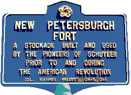
Description: New Petersburgh Fort: 1764, East Schuyler, Herkimer County. Three palisaded log houses, five miles west of Fort Dayton, on the north side of the Mohawk.
New Petersburgh Fort - A stockade built and used by the pioneers of Schuyler prior to and during the American Revolution.
County: Herkimer County
City, State: East Schuyler, New York
Image:
See Also:
New Scotland Avenue (Troop B) Armory
More >>
Description: The New Scotland Avenue (Troop B) Armory was built in 1914. It was designed by Lewis Pilcher.
The armory is sited on a relatively flat, approximately 9 acre lot, the northern half of which is occupied by four large, modern, concrete block storage and maintenence buildings. Only the northern half of the property of approximately 4.5. acres, was included in the Historic Register nomination.
The first unit to use the armory was Troop B, later a Machine Gun Company in WWI. Taken over by the 106th AAA AW Battalion (10th Regt) (1950-52), renamed 127th AAA AW Battalion (1952-53), renamed 127th AAA Battalion (1953-59), renamed 210th Artillery 1st AW Battalion (1959-60), converted and renamed 1st Bn 210th Armor in 1960 until deactivated in 1993), occupied by B Co 1 Bn 101 Cav and various detachments until closure and sale in 1999.
The roughly T-shaped armory consists of a two-story administration building and a three and one-half story drill shed. Both sections rest on raised, parged concrete foundations with granite water tables. The walls are constructed of structural steel framing sheathed with brick curtain walls.
The main block and bastions are encircled by crenelated brick parapets with rifle slits, stone coping, a stone beltcourse, and a machicolated brick cornice. The bastions are ornamented with high relief stone rendering of the seal of New York State.
The five-bay-deep side elevations of the administration building each feature a slightly projecting, three-bay-wide center pavillion with double doors surmounted by large, multi-paned transom lights and a segmentally arched brick surround with a stone keystone.
The two most notable and intact spaces are the company meeting room on the first story of the administration building and the large, unobstructed drill shed. The company meeting room features a simple brick mantel and paneled wainscotting.
The New Scotland Avenue (Troop B) Armory was added to the Historical Register in June, 1991.
County: Albany County
City, State: Albany, New York
New Windsor Cantonment
More >>
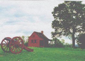
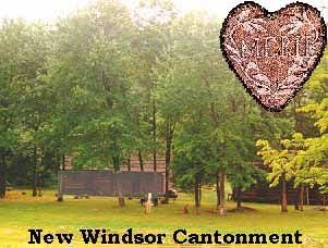
Description: New Windsor Cantonment: 1782-83, Vails Gate, Orange County. During much of the Revolutionary War, New Windsor served as the major depot for the Continental Army and Army Medical Dept. In October 1782, the troops began to arrive and set up tents, while they began building their huts. This encampment or cantonment covered 1600 acres and quartered 6000-8000. Here this army built a log city of over 700 huts for the soldiers and many other out buildings, guardhouses, blacksmith shops, stable, kitchens, hospital, and a 110 by 30 foot assembly hall called the "temple" for worship service were constructed. Troops furloughed June 1783, buildings sold off September 1783. In order to reward the fidelity and faithfulness of three soldiers, Gen.Washington ordered the establishment of an honor, the Badge of Merit be bestowed on them. Today, this honor is known as the Purple Heart. The Town of New Windsor acquired a 167 plus acre tract consisting of much of the former hut sites, and since 1936, the Town of New Windsor and the National Temple Hill Association have strived to ensure the preservation of this the final winter encampment. In addition, the temple site is operated by the State of New York, known as the New Windsor Cantonment with a museum established on site in 1965. Located there is the Mountainville Hut, believed to be a survivor from the encampment. Nearby is Knox's Headquarters - a 1754 stone house built by noted stone mason William Bull, for John Ellison off Forge Hill Road.
County: Orange County
City, State: Vails Gate, New York
Image:
New York State Arsenal
More >>
Description: New York State Arsenal: Designed by Philip Hooker. Built in Albany in 1799. Altered in 1857 and demolished in 1960. At the intersection of Lawrence Street and Broadway.
This information taken from A Neat plain modern stile : Philip Hooker and his contemporaries, 1796-1836 / organized by Emerson Gallery, Hamilton College ; curators and contributing authors, Douglas G. Bucher and W. Richard Wheeler ; edited by Mary Raddant Tomlan in association with Ruth Osgood Trovato ; preface by Roger G. Kennedy.
County: Albany County
City, State: Albany, New York
Newport, Fort
More >>
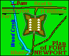
Description: Fort Newport: French and Indian War, On the Oneida Carry/Portage (Rome). Construction started August 1756. A square wooden stockade fort with corner bastions, above Wood Creek between Ft Wood Creek and Fort Williams. Destroyed by British 20 Aug 1756 after French took Oswego. Site is on present Calvert Street between Arsenal Street and Brewer Alley in Rome. See Map at ONEIDA Carry Forts.
County: Oneida County
City, State: Rome, New York
Image:
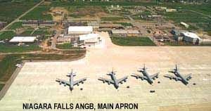
Niagara Falls Air National Guard Base
Niagara Falls BOMARC Base
More >>
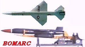
Description: Niagara Falls BOMARC Base: 1961, Niagara County, Niagara Falls. BOMARC Missile Site operational here 1961-1969. The BOMARC B was a Surface-to-Air Cruise Missile with a length of 43 feet, 9 inches and a wingspan of 18 feet, 2 inches. Its range was 440 miles. Essentially an improved and streamlined Bomarc A, (see Suffolk ) the Bomarc B, designated IM-99B, was flight tested in 1959. The Bomarc B added a Thiokol solid rocket booster housed under the missile's body. Capable of producing a thrust of 50,000 pounds, the booster fired for 30 seconds before it was jettisoned. Extra tankage was fashioned within the body of the Bomarc B to house additional JP-4 fuel for two improved Marquardt ramjet engines, each of which had a thrust of 14,000 pounds. This upgraded propulsion system nearly doubled the range of the Bomarc weapons system. The missile also incorporated a more advanced Westinghouse radar system. Boeing delivered a total of 349 Bomarc B missiles to the U.S. Air Force between 1961 and 1965. These either replaced aging Bomarc A missiles at existing bases or facilitated Bomarc B deployment at new sites. Two 28 Missile Squadrons of new Bomarc B deployments occurred Niagara Falls Municipal Airport, New York. Bomarc was the first weapons system to employ an active homing system. Interceptions were controlled by a Semi-Automatic Ground Environment (SAGE) system from Hancock Field AFB, see SAGE, designed to alert and control the SAM toward its target. The site deactivated in 1969.
County: Niagara County
City, State: Niagara Falls, New York
Image:
Niagara, Fort
More >>
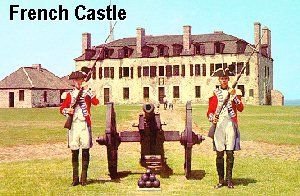
Description: Fort Niagara (Old): 1726, Niagara County, Youngstown. After three previous short term forts (Fort LsSalle) 1669, in ( Fort Conti) 1679 and (Fort Denonville) 1687, the French established a permanent presence in 1726. Starting in June a palisaded two story stone "chateau" with attic was built. Cannon were secretly installed on the second floor (garret) and the attic. In October 1755 the fort was improved with new entrenchments, a barracks for 400, rebuilt palisades of oak, a moat, and improved fields of fire to 1/4 mile. Attacked by Bg. Prideaux (killed) and Sir William Johnson and captured 27 July 1759. Rebuilt through September 1759 under Sir William. Massive stone north and south redoubts built in 1766-77. The British surrendered the fort to the new U.S. government in 1796. The British retook the fort during the war of 1812 and returned it after the war. Brick walls and a moat were added in 1861.
For more information see: www.oldfortniagara.org/
See: Fort Niagara under the French, English, and the United States by Henry R. Marshall.
Fort Niagara (New): 1841, Niagara County, Youngstown. In 1841 new building construction was started adjacent to the old fort's battlements consisting of Barracks, Officer's Quarters, and Life Saving Station. More buildings were added on the surrounding plain during its use as a training post from 1903. In 1917 through 1922 it was an Officer's Training Camp and ROTC. From 1922 to 1940 it was the Base for the 28th Infantry Regiment, during which period many improvements and preservation work was done. From 1940 to 1943 it was a Reception Center for Army draftees, and more than 11 new buildings were constructed. From 1943 to 1945 it was a Reception Center, then Separation Camp, and also served as a prisoner of war camp. In 1945 the base was closed and by 1946 was being used for Veteran's housing. Most of the Base, except for housing was turned over to the Niagara Frontier Parks Commission.
Fort Niagara (NIKE): 1950, Niagara County, Youngstown. In 1950 a detachment of the US Air Force occupied some building, and by 1953 families were notified to vacate. The Fort was occupied by the 2nd Antiaircraft Group and rehabilitation and modernization was completed by 1955. Nike sites controlled from here were at Model City, Cambria Center, Grand Island, Millersport, Lancaster, Orchard Park, and Hamburg. Nike-Ajax Missile operations until 1963 when deactivated. Most of the buildings were subsequently removed and development started as historical site in 1963 to present, and now owned by the State Parks and operated by a not-for-profit organization.
See http://nikemissile.org/NFBU/NFBU52-70.pdf for more information
County: Niagara County
City, State: Youngstown, New York
Related Links:
http://www.oldfortniagara.org/
Image:
Nicholson, Fort
More >>
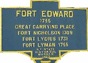
Description: Fort Nicholson: 1709, Fort Edward. This location was the Southern terminus of the "Great Carrying Place", a 11 mile route from the Hudson River to the forks of Wood Creek at Fort Anne leading to Lake Champlain. The British during Queen Anne's War erected a stockade in the area, only to be abandoned at the end of the war. Rebuilt as Fort Lydius 1732.
Fort Edward, 1755, Great Carrying Place, Fort Nicholson, 1709; Fort Lydius, 1731; Fort Lyman, 1755
County: Washington County
City, State: Fort Edward, New York
Image:
NIKE Bases
More >>
Description: Niagrara Frontier: Buffalo Area; included sites at (BU-52) Hamburg, (BU-18) Lancaster / Milgrove, (BU-09) Millersport / Ransom Creek, and BU-34/35) Orchard Park. Later merged with Niagara Falls Area.
Niagara Frontier: Niagara Falls Area; included sites at (NF-16) Cambria / Sanborn, (NF-41) Grand Island, (?) Lockport, (NF-03) Model City, (HQ) Fort Niagara, and (?) Sanborn.
NYC/Philadelphia Area: In New York State included sites at (NY-24) Amityville / Farmingdale, (NY-25) Brookhaven / Rocky Point, (NY-23) Hicksville / Oyster Bay, (NY-20) Huntington / Lloyd Harbor, (NY-09) Kensico / White Plains, (NY-29/30) Lido Beach, (NY-03/04) Mount Nebo / Orangeburg, (NY-99) Ramapo / Spring Valley, (NY-15) Fort Slocum, (?) Tappan, and (NY-49) Fort Tilden.
For more information see
alpha.fdu.edu/~bender/NYsites.html
Image:

See Also:
Niskayuna, Fort
More >>
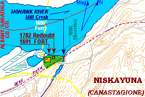
Description: Fort Niskayuna: Also known as Canastaginone. Also spelled Canastagone, then Nistigone. First mentioned in 1691. Site was 14 miles from Albany on the South side of the Mohawk River at Fort's Ferry and a few hundred feet West of Mill Creek. Referenced in 1702 as a pretty large stockaded fort now gone to ruin. A stone redoubt was proposed in 1702 and a bill for "repairs" was submitted in 1704. A house was later constructed on the site and the land was subsequently taken in 1911 for a flood basin of the Improved Erie Barge Canal, a railroad (now bike path) and new River Road skirted the flood basin. The exact site or remains have not been researched.
County: Albany County
City, State: Niskayuna, New York
Image:
Nonsense, Fort
More >>
Description: Fort "Nonsense": Poquott, Suffolk. American 1813, one gun, on Port Jefferson Harbor.
County: Suffolk County
City, State: Poquott, New York
Noonten Eylandt Fort
More >>
Description: Nooten Eylandt Fort: Governor's Island, Dutch 1624-25. Abandoned for Fort Amsterdam, Manhattan.
County: New York County
City, State: Governors Island, New York
See Also:
North Redoubt
More >>
Description: North Redoubt: 1778, Garrison, American. In 1778 as part of the enlarged defenses of West Point two redoubts (North and South) were built two miles southeast of Constitution Island in the highlands en-route to Continental Village. Constructed on two sides of the hill now known as Fort Hill between the Village of Garrison and US Route 9.
County: Putnam County
City, State: Garrison, New York
Numbered Blockhouse in New York City
More >>
Description: Blockhouse 1 : 1814, NYC, Central Park, near 7th Ave entrance at 110th Street. May be same as Fort Clinton (4) near 5th and 107th.
Blockhouse 2 : 1814, NYC, South side of 114th Street west of Morningside Avenue.
Blockhouse 3 : 1814, NYC, South side of 121st Street west of Morningside Avenue.
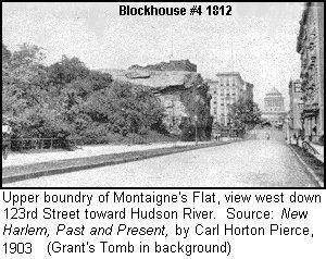
Blockhouse 4 : 1814, NYC, South side of 123rd Street near 10th Avenue in Morningside Park. The ruins of Blockhouse #4 marked Morningside Park's northern end at Amsterdam Avenue until Public School #36 was built there in 1967. Picture from 1903 shows ruins at top of 123rd Street cut (left/South). Early 1877 etching of this view can be found at Fort Laight entry. Info credit to Eric K. Washington, The Manhattenville Heritage Society
Upper Boundry of Montaign'e Flat, view west down 123rd street toward Hudson River. Source: New Harlem, Past and Present, by Carl Horton Pierce, 1903. (Grant's Tomb in background.)
County: New York County
City, State: New York City, New York
Image:
See Also:
Numbered Forts in New York City
More >>
Description: Fort Number 1: 1776. Built by Col. Swartwout on the southwest slope of Spuyten Duyvil Hill at today's West 230th Street and Sycamore Avenue. Small square fort with abatis. Abandoned without fight. Manned by Hessians until Nov 1778 when replaced by British Guards, abandoned and demolished Fall 1779. Also halfmoon earthenwork at mouth of Spuyten Duyvil Creek.
Fort Number 2: 1776. Built by Col. Swartwout on the crest of Spuyten Duyvil Hill today 200 feet south of 230th Street and 230 feet west of Arlington Avenue. A small circular abatised fort, abandoned Oct 1776, occupied by Hessians who added a small redan on west side, abandoned and destroyed Nov 1779. During construction may have been named Fort Swartwout.
Fort Number 3: 1776. Built by Col. Swartwout on eastern slope of Spuyten Duyvil Hill vicinity today of Netherland Avenue between 227th and 231st Streets. A square abatised earthwork it was evacuated Nov 1776, reoccupied by Hessians who in 1778 added a curtain wall to Fort Number 2. Abandoned by British Nov 1779 ruins existed to 1781.
Fort Number 4: 1776. A square palisaded earthwork redoubt. Near present south end of Jerome Park Reservoir, 700 feet east of Sedgewick Avenue. Assaulted twice and captured, occupied by British and Hessians. Redoubt was added in July - October 1777. Demolished in Fall 1779. Excavations in 1910 showed officer quarters and guard house structures.
Fort Number 5: 1777. British square abatised earthwork. Located on Kingsbridge Road covering Dyckman Bridge over the Harlem River. Now the grounds of U.S.Veteran's Hospital. Demolished in Fall 1779. Fort was not in action.
Fort Number 6: 1777. British earthwork. Also on the grounds of the Veteran's Hospital. Destroyed September 1779, not in action.
Fort Number 7: 1776. British earthworks for 20 cannon at present day Fordham Road and Sedgewick Avenue. Constructed for attack on Fort Washington. Reconstruction started in July 1777 into a square abatised fort. Barracks erected between fort and King's Redoubt to the west in December 1778. Stone magazine and earthworks torn down September 1779.
Fort Number 8: 1776. British four-pointed star fort with abatis. Stood on east side of Harlem River on today's NY University Campus, University Heights, Fordham, Bronx (Battery Hill). Schwab Mansion 1857 built on site. Abandoned and destroyed October 1782. Just to the north was the earlier Rebel Redoubt.
Fort Number 9: 1776. See Fort Prince.
County: http://dmna.ny.gov/forts/fortsT_Z/washingtonFort.htm
City, State: New York City, New York