H. G. Wright, Fort
More >>
Description: Fort H. G. Wright was a defensive structure located on Fishers Island, off the eastern tip of Long Island, New York. It was constructed in 1900 on the western end of the island. The fort was initially constructed to protect the Long Island Sound and was armed with two 12-inch and two 10-inch rifles on disappearing carriages. By 1921 the fort contained several batteries, including Battery Clinton with four 12-inch mortars, Battery Butterfield with two 12-inch disappearing guns, Battery Barlow with two 10-inch disappearing guns, and Battery Hoffman and Hoppock both armed with two 3-inch pedestal guns. In addition, Battery Hamilton and Battery Marcy, each contained two 6-inch pedestal guns, but had been removed by 1921. The fort was operational during World War II and boasted a small airfield. It was linked with Fort Terry, Fort Michie, and Camp Hero, which were sub-posts of the fort. Fort H. G. Wright was closed in the late 1950s and was subsequently sold to private businesses and individuals.
Notes about batteries in 1921:
Battery Clinton, 4 - 12" Mortar
Battery Butterfield, 2 - 12" Disappearing
Battery Barlow, 2 - 10" Disappearing
Battery Hamilton, was 2 - 6" Pedestal, removed by 1921
Battery Marcy, was 2 - 6" Pedestal, removed by 1921
Battery Hoffman, 2 - 3" Pedestal
Battery Hoppock, 2 - 3" Pedestal
Operational during WW2 with a small airfield. Linked with Fort Terry, Fort Michie which were sub-posts, and Camp Hero. Closed in the late 1950s and sold to private interests.
City, State: Fishers Island, New York
Conflict/Time Period: 1879-1949
Haldimand, Fort
More >>
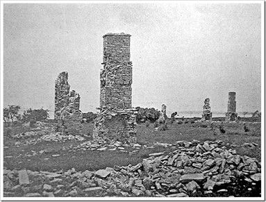
Description: Fort Haldimand was built near Cape Vincent in the St. Lawrence River in Jefferson County, New York. It was originally used by French fur traders but was first used militarily by the British in 1778 under the command of St. Leger. The fort was named “Fort Carleton” to honor the previous Governor of Ontario, Major General Sir Guy Carleton, but was later renamed “Fort Haldimand” for then Governor of Ontario, General Sir Frederick Haldimand. The fort was designed as an octagon, and boasted three bastions, each with space for four guns, as well as ditches, magazines, and barracks. However, construction on the fort was never completed, and it was abandoned in 1783 after the conclusion of the Revolutionary War. Despite the Jay Treaty of 1794, the British did not leave the fort, and it became the principal British naval base on Lake Ontario. At the start of the War of 1812, Captain Hubbard, of the American Army captured the fort in June of 1812. Eventually, American forces destroyed and abandoned the fort.
County: Jefferson
City, State: Buck's Island, New York
Conflict/Time Period: Revolutionary War
Image:
See Also:
Half-Moon, Fort
More >>
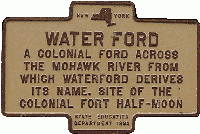
Description: (1): Built in 1691, Fort Half-Moon was built to defend the town of Waterford, in Saratoga County, New York. The fort was built to protect the Schagticoke Native Americans on the west bank of the Hudson. The fort was located north of the city. It is possible that an existing fort from 1669 was relocated and rebuilt at this time. In 1691, the fort was garrisoned with 50 Fusiliers originally from Albany. By 1702 the fort was in ruin, but it was rebuilt in 1704.
(2): In 1757, a fort was constructed in Waterford. The fort was built on three-foot stilts at the intersection of the Mohawk and Hudson Rivers, opposite Haver's Island. It was described in 1759 as a redoubt of poor quality. However, when Haver's Island was fortified in 1777, there was no mention of the fort, leading to doubts surrounding its existence.
(3): 1757, Saratoga County, Waterford. A new fort was built on 3 foot stilts at the North point of land at junction of the Mohawk and Hudson Rivers, opposite Haver's Island. Described in 1759 as a poor redoubt. Fortification of Haver's Island in 1777 does not mention the fort.
County: Saratoga
City, State: Waterford, New York
Conflict/Time Period: 1757
Image:
See Also:
Hamburg Nike Base
More >>
Description: In 1956, the Hamburg Nike Base was built in Hamburg, Erie County, New York. The base served as a double site launcher and integrated fire control area for Nike-Ajax missiles. The control center was located at New Lake View Road, 2 E. Heltz Road, and today hosts town offices. The launcher area was located at New Lake View Road, 1 E. Heltz Road, and is now covered by a bike track and the Hamburg Town Park and Bulk Storage. The base operated from 1956 to 1961 and was also known as “BU-52”. The base was referred to as a “double site” as its defense systems could target two incoming missiles simultaneously.
County: Erie
City, State: Hamburg, New York
Conflict/Time Period: Cold War
Hamilton, Fort
More >>
Description: Fort Hamilton was established in 1825 in Kings County, Brooklyn. It is one of the three oldest Army posts in the country. Initially, the site was used as a battery, and was known as “Narrows Fort”. On July 4, 1776, the fort was used by the armies of American General Henry Knox to shell the British ship H.M.S. Asia as it approached the harbor. The Americans withdrew upon the British landings of August 1776 and the site was used by the British until 1782. A blockhouse and 30-gun earthworks were constructed in 1812 on Denyse Heights near the site and were collectively known as Fort Lewis. A permanent granite fort, named for the first Secretary of the Treasury Alexander Hamilton, began construction in 1825 and was completed by 1831 to protect the Narrows. Between 1841 and 1842, new gun emplacements were built under the supervision of Captain R.E. Lee. By the dawn of the twentieth century, new "disappearing" carriages and breach loading 12-inch guns were installed, along with massive concrete walls. By 1924, coastal defense had moved to Fort Tilden and Fort Hamilton became an infantry post. Most of the coastal guns were removed by 1941. The current Fort Hamilton, located at the base of the Verrazano Narrows Bridge in Brooklyn, New York, is the only active-duty military installation in the New York City metropolitan area. Its purpose is to provide premium base operations and area support for the Northeast region, as well as community housing, and protocol/foreign liaison support for the Army, the Department of Defense, and the United Nations. The fort covers an area of 177 acres.
Notes:
- In 1921, the status of the batteries at the fort was as follows: Battery Piper had 4 12" mortars (originally an 8 gun battery, 4 moved to Tilden), Battery Doubleday had 2 12" disappearing guns, Battery Brown had 2 12" disappearing guns, Battery Neary had 2 12" non-disappearing guns, Battery Gillmore had 2 10" disappearing guns, Battery Spear had 3 unknown guns, Battery Burke had 2 unknown guns, Battery Livingston had 2 6" pedestal guns (2 vacant), Battery Mendenhall had 4 demonstration guns, Battery Johnston had 2 6" pedestal guns, Battery Griffin had 2 3" pedestal guns and 2 demonstration guns, and there were 2 3" anti-aircraft guns that were being dismounted in 1935.
County: Kings
City, State: Brooklyn, New York
Conflict/Time Period: Revolutionary War-Present
Hancock Field
More >>
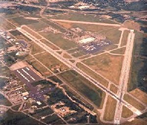
Description: Hancock Field was a military base located in Syracuse, New York, built in 1942. It was home to the 24th Air Division and closed its doors in 1983. Part of the north post was retained for housing and the NYANG 152nd Air Control Group, while part of the south post was retained for the NYANG 174th Attack Wing. The majority of the base presently hosts the Syracuse Hancock International Airport. The base was also home to an Air Defense Control Center on the north post, which had control over the BOMARC missiles located in Niagara Falls. The SAGE (Semi-Automatic Ground Environment) system was also located at Hancock Field. John F. Wierda reported that he was assigned to the SAGE center at Hancock Field from 1970 to 1974, during which time it was the 21st Air Division/NORAD Region (SAGE). The base was originally named Syracuse Army Air Base and was built as a staging area for warplanes during the Second World War. It was later home to the 305th Bombardment Group and the 138th Fighter Squadron of the New York Air National Guard. In 1952, the 32nd Air Division made Hancock Field its headquarters. The base was later the base of operations for the 26th Air Division (SAGE) and the Boston Air Defense Sector (BOADS). In 1966, the 35th Air Division was headquartered at the base, and in 1969, the 21st NORAD Region/Air Division made the facility its headquarters. The 21st NORAD Region/Air Division provided air defense for more than 50 million Americans living along the Eastern Seaboard.
John F. Wierda submitted the following:
When I was assigned to the SAGE center at Hancock Field NY, it was the 21st Air Division / Norad Region (SAGE) that was from 1970-1974.
History
Hancock Field was named for Clarence E. Hancock, a prominent local citizen, and member of the United States House of Representatives.
In contrast to its air defense mission of today, Syracuse Army Air Base — as it was first known — was built and activated in 1942. during the early days of World War II, as a staging area for warplanes bound for England.
Many of the "hardstands" and taxiways now overgrown by weeds were scenes of feverish activity almost 31 years ago when B-17s, B-24s, transports and many other types of aircraft were being prepared for the long hop across the North Atlantic.
One of the first units to pass through Hancock Field was the 305th Bombardment Group, flying B-17s and led by Col. Curtis E. Lemay, who later became the Air Force Chief of Staff.
Army Air Forces left Hancock Field in 1946 with the 138th Fighter Squadron of the New York Air National Guard remaining as the sole military occupant of the field until the Air Force returned in 1952 with the Headquarters of the 32nd Air Division. Building 3, the present Base Headquarters, was built as the blockhouse for the 32nd pre-SAGE manual division under the Eastern Air Defense Force. The 32nd was phased out and replaced by the 26th Air Division (SAGE) when the SAGE system became operational on Jan. 1, 1959. At approximately the same time, the Syracuse Air Defense Sector became operational.
In September, 1963, the 26th Air Division Headquarters was moved to Stewart AFB, N.Y., and the Syracuse Sector, in a realignment of sector boundaries, became the Boston Air Defense Sector (BOADS).
On April 1, 1966, a reconfiguration of the Air Defense Command renamed the Boston Air Defense Sector as the 35th Air Division, with headquarters remaining at Hancock Field. The 26th Air Division at Stewart AFB became Headquarters, First Air Force (ADC).
In November, 1969, in another Aerospace Defense Command realignment, the 35th Air Division was deactivated and replaced by the 21st NORAD Region/Air Division, with headquarters again at Hancock Field.
Today the 21st NORA D Region/Air Division, with its radar and fighter units scattered throughout the northeast, Iceland, Greenland and sections of eastern Canada, provides air defense for more than 50 million Americans living within 500,000 square miles of territory including many of the eastern seaward approaches to the United States and Canada.
County: Onondaga
City, State: Syracuse, New York
Conflict/Time Period: Cold War-Present
Branch: NYANG
Image:
See Also:
See also SAGE for information on Air Defense Control Center which was on the North Post, control for Niagara Falls' BOMARCs.
Hardin, Camp
More >>
Description: Camp Hardin was a military training camp located in Sand Lake, Rensselaer County, New York. It was constructed in 1860 for the purpose of training Union Army recruits from the Troy area for combat in the Civil War. The camp was named for a Regimental Commanding Officer of the 2nd NY Vol. Infantry. In 1898, it was used as a demobilization camp for the 2nd NY Vol. Infantry and was occupied from August to September of that year.
County: Rensselaer
City, State: Sand Lake, New York
Conflict/Time Period: Civil War, Post-Civil War
Hardy, Fort
More >>
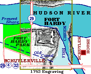
Description: In August of 1755 Fort Hardy was built by General Phinehas Lyman in Saratoga County, New York, specifically in Schuylerville. The defensive structure was erected at the northwest intersection of the Fish Kill and Hudson River and stood adjacent to a ferry that crossed the Hudson, as well as one of the first bridges in the area. The fort was named for the then Governor of New York, Sir Charles Hardy. Fort Hardy was intended to serve as a supply post for expeditions that were being planned against Crown Point, one of them being The Johnson Expedition. Today, the site of the fort serves as a recreational park for community members to enjoy.
County: Saratoga
City, State: Schuylerville, New York
Conflict/Time Period: 1755
Related Links:
Image:
See Also:
Harrison Blockhouse
More >>
Description: Harrison Blockhouse was established in 1756, in Montgomery County, New York, in the town of St. Johnsville. It was constructed from wood by British forces on the north side of the Mohawk River, to the west of Caroga Creek. The fort was abandoned by 1760.
County: Montgomery
City, State: St. Johnsville, New York
Conflict/Time Period: 1736/1750
Related Links:
Hart Island
More >>
Description: In the 1860s, Hart Island was established in Bronx County, New York City. The island was originally used by Union Soldiers as a training camp during the Civil War. However, in 1865, the island was fenced in and converted into a Confederate prisoner of war camp which held 3,413 prisoners at its peak. Almost a century after the war, in 1955, Hart Island was occupied as part of the Nike Base NY-15 at nearby Fort Slocum, by the 66th Guided Missile Battalion, and it remained under their control till 1960. Today, Hart Island is part of the New York City Prisons system and serves as a potter's field and cemetery. In addition, parts of the island remain privately owned.
County: Bronx
City, State: New York City, New York
Conflict/Time Period: 1860s-Present
See Also:
Haver Island
More >>
Description: Haver Island saw the construction of a fort in 1777 in Albany County, on Peebles Island. It was used as a campground along with Van Schaick Island as early as 1709. Van Schaick and Haver Island were once again utilized as a camp and supply depot in 1777. The fort came equipped with three earthwork Batteries, various blockhouses, and was constructed under the leadership of Polish military engineer, Tadeusz Kościuszko, in August 1777. Haver island was occupied in 1782 due to conflicts with Vermont.
County: Albany
City, State: Cohoes, New York
Conflict/Time Period: Revolutionary War
Hazelhurst Field
More >>
Description: Hazelhurst Field was built in 1915, in Hempstead, Nassau County, on Long Island. In 1917 when the United States declared war on Germany, the U.S. Army converted a two-year-old National Guard base, on the former site of Camp Black, into Hazelhurst Field. The field was named for Leighton Hazelhurst, who was the first NCO killed in an aviation accident. After the First World War, the base became a civilian airfield. In 1920, it was renamed “Curtis Field”, until it merged with the adjacent Roosevelt Field in 1929. By 1951 the airfield closed its doors to make way for construction of the nation’s second ever shopping mall, known today as Roosevelt Field. The mall opened just in time for Christmas in 1956 and has remained tremendously successful for decades and is presently home to a whopping 243 stores.
County: Nassau
City, State: Hempstead Plains, New York
Conflict/Time Period: World War 1 - 1951
See Also:
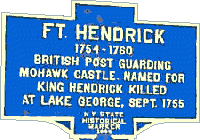
Hendrick, Fort
More >>
Description: Fort Hendrick was built in 1754, in Herkimer County, in the town of Danube. It was located at the Upper Castle of the Mohawks, sometimes referred to as Canajoharie. The Upper Castle was established around 1710 and an earlier fortification was constructed in 1747. The fort was situated on flatlands east of Nowadaga Creek and south of the Mohawk River. Due to the fighting of the Seven Years’ War spilling over into the New World, improved fortifications were constructed on the site of the original two blockhouses and were completed by August of 1755. Fort Hendrick was a square of upright picket-fence pieces joined together with lintels, and stood at fifteen feet tall, and one foot thick, and featured portholes as well as an interior platform. It reportedly took the average man one hundred paces to walk along one side. Some small cannons (possibly swivel guns) were included in each bastion. A house on each curtain wall for stores and barracks served to accommodate the soldiers. The base’s garrison was comprised of one officer, with twenty-five men under his command. The fort was named for the Mohawk leader known as Hendrick, who was killed at Lake George one month after the fort’s completion. Markers for Hendrick and Canajoharie are three kilometers apart although they identify the same place.
County: Herkimer
City, State: Danube, New York
Conflict/Time Period: 1747
Image:
Hennepin, Fort
More >>
Description: In December of 1678, a team on an expedition, led by Pierre LaMotte, constructed a cabin surrounded by palisades near the foot of the Lewiston escarpment in Niagara County, New York. The fort was named Fort Hennepin, in honor of a Belgian priest and historian traveling with the expedition, as recounted in a 1914 work by Peter Porter. However, within a year, the fort was replaced by Fort Conti, which was located closer to the mouth of the Niagara River and stood on the future site of Fort Niagara. In 1721, the French built an unnamed blockhouse at the same location. Despite having no official name, it was sometimes referred to as Joncaire's Blockhouse or Magazin' Royal, but it was eventually replaced by an unnamed British facility in 1761.
Notes:
For information on companion works at the top of the escarpment, see Fort Gray.
County: Niagara
City, State: Lewiston, New York
Conflict/Time Period: 1678
Image:

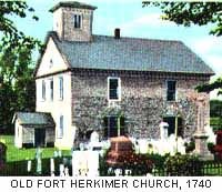
Herkimer Church Fort
More >>
Description: In 1756, a stockade was built around the Herkimer Dutch Reformed Church, located on the south side of the Mohawk River, and across from the west side of Canada Creek in Herkimer County, New York. This fort was known as the Herkimer Church Fort. The structure was originally built around 1740. Later, the old fort was rebuilt around the church with an added blockhouse, about a quarter mile west of the previous site. During the Revolutionary War, the church was re-fortified with a strong palisade and earthwork. In 1812, the church was renovated and enlarged, but the ramparts were destroyed in 1918 during the construction of the Barge Canal.
County: Herkimer
City, State: Mohawk, New York
Conflict/Time Period: 1756
Image:
See Also:
Hero, Camp
More >>
Description: Camp Hero was constructed in 1941 in Montauk, Suffolk County, New York, on the eastern tip of Long Island. The United States Navy built docks, a seaplane hangar and a barracks which ultimately became the now closed-down Ocean Science Lab. Camp Hero consisted of two 16-inch gun emplacements, and one 6-inch gun. Camp Hero was linked with Fort Terry, Fort Michie, and Fort Wright. An air base was also constructed during WW2. It was deactivated following the conclusion of the conflict and was used for Army Reserve training until 1950. In 1957 it was transferred to the Air Force and the 773rd Aircraft Control. The unit as well as the base were decommissioned and sold in 1982.
County: Suffolk
City, State: Montauk Point, New York
Conflict/Time Period: World War 2 thu Cold War
Hess, Fort
More >>
Description: Fort Hess was built in 1776, in Montgomery County, New York. It was a small, fortified stone dwelling belonging to John Hess located between Palatine Church and St. Johnsville, around one mile west of Fort Fox and three quarters of a mile south of Fort Klock.
County: Montgomery
City, State: Palatine, New York
Conflict/Time Period: Revolutionary War
Hickory, Fort
More >>
Description: Fort Hickory was built in 1812, in Franklin County, New York, specifically in the town of Chateaugay. The construction is a blockhouse, located one mile South of Larkville. The blockhouse was occupied during the War of 1812 by Samuel Hollenback.
County: Franklin
City, State: Chateugay, New York
Conflict/Time Period: War of 1812
Hicksville Nike Base
More >>
Description: Hicksville Nike Base was founded in 1955 on Long Island and served as a launch area for missiles. The base may have also been known as Brookville. The base boasted thirty Nike Ajax missile launchers, three magazines, one type "B" and the other two being type "C". The base was deactivated in 1963 and was not upgraded further. Presently, the area that once hosted the base is publicly owned and was transformed into what is now Native Park.
County: Nassau
City, State: Hicksville, New York
Conflict/Time Period: Cold War
Branch:
Hill, Fort
More >>
Description: Fort Hill (1) was a fortified house that saw combat in both the Seven Years’ War and the American Revolution. It was located on a hill in the western reaches of St. Johnsville near East Canada Creek. It is speculated that it and Fort House are one and the same.
Fort Hill (2), also known as the North Redoubt and South Redoubt, was located in the highlands on the east side of the Hudson River. The North and South Redoubts were situated two miles southeast of Constitution Island, between Garrison, a town in Putnam County, New York, and Route 9. The redoubts were part of a line of structures collectively known as the “West Point defenses”.
County: Montgomery
City, State: St. Johnsville, New York
Conflict/Time Period: French and Indian, Revolutionary War
Hoffman Island
More >>
Description: Hoffman Island Maritime Service Training Station was opened on September 7th, 1938, on Staten Island. It was operated by the USCG to train merchant marine officers and seamen. It was the oldest station of the United States Maritime Service. Today, the island is part of the Gateway National Recreation Area and is not open to the public.
County: Staten Island
City, State: New York City, New York
Conflict/Time Period: 1938
Branch:
Related Links:
Horn, Fort
More >>
Description: Fort Horn was built in 1814, during the War of 1812, in New York City. It was located in Morningside Park at 123rd Street and Amsterdam Avenue and was named for Major Joseph Horn.
County: Manhattan
City, State: New York City, New York
Conflict/Time Period: 1814
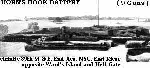
Horn's Hook Battery / Fort
More >>
Description: Horn's Hook Battery, also known as Fort Horn's Hook and Thompson's Battery, was a nine-gun battery planned in February 1776 to defend Manhattan Island during the Revolution. It was located at what is now the intersection of 89th Street and East End Avenue, opposite Ward's Island and Hell Gate. In September 1776, the fort came under fire from British forces stationed in Queens. During the British occupation, the battery was restored and additional palisades and supporting batteries, as well as a blockhouse were added. After the war, the new owner, Archibald Gracie, leveled the works in 1794 and erected a mansion, which now serves as the home of the city’s mayors.
County: Manhattan
City, State: New York City, New York
Conflict/Time Period: Revolutionary War
Image:
See Also:
Fort Wiki: http://www.fortwiki.com/Horn%27s_Hook_Fort
Hospital Redoubt
More >>
Description: Hospital Redoubt was founded in April of 1776, in New York City. It consisted of fortified breastworks surrounding a hospital, at the intersection of present-day West Broadway and Worth Street (also known as Duane Steet). Fortifications were destroyed or removed during the Winter of 1776.
County: Manhattan
City, State: New York City, New York
Conflict/Time Period: 1776
House, Fort
More >>
Description: Fort House was a fortified structure located in St Johnsville, in Montgomery County, New York. The fort’s construction was overseen by Christian House and was owned by Jacob George Klock, a local politician who represented Tyron County in the New York State Assembly from 1777 to 1778. The fort was situated on the western edge of the village St. Johnsville, just six miles northwest of Nelliston. It's possible that Fort House and Fort Hill are the same structure.
County: Montgomery
City, State: St. Johnsville, New York
Conflict/Time Period: French and Indian War
See Also:
Hudson, Fort
More >>
Description: Fort Hudson was built in 1811 on the east coast of Staten Island to defend the harbors of New York City. It's possible that Fort Hudson was only a battery, as it came under the control of nearby Fort Tompkins in 1812. It is also speculated that Fort Hudson may have become part of Fort Wadsworth.
County: Staten Island
City, State: New York City, New York
Conflict/Time Period: 1811
See Also:
Hunter, Fort
More >>
Description: Fort Hunter was built in 1711 in Montgomery County, New York by the British Empire. The original Fort Hunter, also known as Old Fort Hunter, was built between 1711-12 at the request of Governor Hunter. The fort was built for the purpose of protecting the Native American tribe, known as the Mohawks. The fort was a 12-foot-high stockade, which, impressively, spanned 150 feet on each of its four sides. The fort surrounded the Queen Anne Chapel. There were 24-foot square-shaped blockhouses on each corner of the stockade, each standing two stories high. The blockhouses were double-loopholed and boasted chimneys and were each armed with seven and nine pounder cannons. Each blockhouse could hold twenty men. The compound also featured thirty cabins for residents. Records indicate that improvements were made to the fort in 1755. Old Fort Hunter was worn down by the beginning of the Revolutionary War, particularly after it suffered an accidental fire in 1773 which destroyed one blockhouse and two walls. The parsonage, located one mile east of the fort, was restored and used during the Revolutionary War as a fort, and may have been stockaded further. The fort and chapel were located near the village of Fort Hunter on the south side of the Mohawk River at Schoharie Creek. The fort and chapel were demolished in 1820 for the Schoharie Crossing of the Erie Canal. There is another account that indicates Fort Hunter was built for the Palatines in 1724.
County: Montgomery
City, State: Fort Hunter, New York
Conflict/Time Period: 1711
See Also:
Huntington Nike Base
More >>
Description: The Huntington Nike Base (known as NY-20) was an active military facility in operation from 1955 to 1963, located in Suffolk County, New York, on the east end of Long Island. The base served as a launcher area for thirty Nike-Ajax missiles and the IFC area was located in Lloyd Harbor. The base closed its doors in 1963 and the site was subsequently demolished.
County: Suffolk
City, State: Lloyd Harbor, New York
Conflict/Time Period: Cold War
Branch:
Hurley Blockhouse
More >>
Description: The Hurley Blockhouse is a historical fortification that dates back to the 1660s. It was built by Dutch forces in New Netherland, in what is now Ulster County, New York, and was located in the village of Hurley. The blockhouse was constructed to provide protection for Dutch settlers from the nearby Esopus Native American tribe. The blockhouse was built with palisades to act as a barrier against enemy attacks.
County: Ulster
City, State: Hurley, New York
Conflict/Time Period: 1660s
Branch:
Hyde Bay Camp
More >>
Description: Hyde Bay Camp, also known as Hyde Bay Fort, was established in 1779 on Otsego Lake in Otsego County, New York. It was occupied by the 4th Massachusetts Regiment during its era of operation. The camp/fort site is located just over two miles south of Route 20 at Middle Springfield.
County: Otsego
City, State: Otsego Lake, New York
Conflict/Time Period: 1779
Branch: