
Ramapo Nike Base
Full History >>
Description: Ramapo Nike Base (NY-99): 1956-63, Launcher Area for 30 Nike-Ajax Missiles, IFC area was Spring Valley. Inactivated 1963. Site owned by East Ramapo School District and is partially intact. See also NIKE
For more information see http://alpha.fdu.edu/~bender/NY99.html (link opens new window)
County: Rockland County
City, State: Ramapo, New York
See Also:
Ransom Creek Nike Base
Full History >>
Description: Ransom Creek (BU-09) Nike Base: Mid 1950s-Mid 1960s, Integrated Fire Control Area for Nike-Ajax Missiles, associated launcher area was Millersport. See also NIKE
County: Niagara County
City, State: Buffalo, New York
See Also:
Rathburn, Camp
Full History >>
Description: Camp Rathburn: 1860s, Chemung County, Elmira. Temporary Civil War Encampment. See also Post Barracks, and Camp Robinson, looking for more information on location.
County: Chemung County
City, State: Elmira, New York
See Also:
Rebel Redoubt
Full History >>
Description: Rebel Redoubt: 1776, Bronx, American. Captured by the British who added an abatis. Abandoned Fall 1779. North of British Fort Number 8.
County: Bronx County
City, State: The Bronx, New York
Branch:
Red Fort
Full History >>
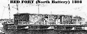
Description: Red Fort: 1807-11, New York City, also known as North Battery, 200 feet into Hudson River, off Hubert Street, about pier 27 area. Constructed of red sandstone hence its name. 16 guns. Closed 1831.
[Description of image]
Red Fort (North Battery) 1808
County: New York County
City, State: New York City, New York
Image:
Red Hook Barracks
Full History >>
Description: Red Hook Barracks: 1776-82, Red Hook, Dutchess County. Five miles north of Rhinebeck on east bank of the Hudson were the American Barracks. Garrisoned to protect the river crossing and powder mill. Major rest area for units moving between New England and Mid Atlantic.
County: Dutchess County
City, State: Red Hook, New York
Redford Atlas
Full History >>
Description: Redford ATLAS F, Site #8: 1961-65, Clinton County, Redford. See ATLAS F for detailed information.
County: Clinton County
City, State: Redford, New York
See Also:
Reid (Reed), Fort
Full History >>
Description: Fort Reid(Reed): 1779, Chemung County, Elmira. Erected during Iroquois expeditions in the summer of 1779. Located at junction of Chemung (Tioga) River and Newtown Creek. Destroyed September 1779 at completion of the expedition.
County: Chemung County
City, State: Elmira, New York
Branch:
Rensselaer, Fort
Full History >>
Description: Fort Rensselaer(1): Revolutionary War, also known as Fort Plain. South side of Mohawk River near village of Fort Plain. See Fort Plain.
Fort Rensselaer(2): 1750, Montgomery County, Canajoharie. One and 1/2 story fortified stone house of Marte Janse Van Alstyne on present day Moyer Street. Also known as Fort Van Alystyne. Meeting place of Tryon County Committee of Safety. Fortified early in war unknown if palisaded.
County: (1) Montgomery County (2) Montgomery County
City, State: (1) Fort Plain, New York (2) Canajoharie, New York
See Also:
Rheimensnyder's Fort
Full History >>
Description: Rheimensnyder's Fort: 1776, Herkimer County, Dolgeville. Blockhouse built by Henry Rheimensnyder. Area attacked April 1780. Burned down a few years after the war.
County: Herkimer County
City, State: Dolgeville, New York
Richmond, Fort
Full History >>
Description: Fort Richmond (1): 1776, Staten Island, Richmondtown. British constructed 3 redoubts from July 1776 to October 1779, on the sides of a hill with a garrison in the middle. Each redoubt was about 50 feet square with ditching. Renovated in 1781, evacuated 1782. Located on grounds of La Tourette Country Club, some archeological work done.
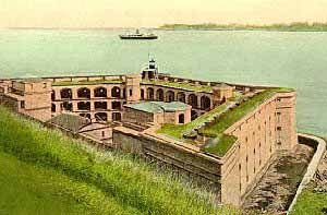
Fort Richmond (2): 1663-1776-1807-1812, Staten Island. The site was first fortified with a 1663 blockhouse and then during the Revolutionary War as the American redoubt Flagstaff Fort (1776), taken by the British it was enlarged and used to 1783. NYS Started a masonry fortification here in 1807 - 1811, (Water Battery, 1811) on East coast of Staten Island for harbor defense. Controlled by Fort Tompkins 1812. In the early 1860s on an early 1840 recomendation of the Engineering Officer at Fort Hamilton (a CPT R.E.Lee, later of the Confederate Army) it was rebuilt as a five foot thick, three-tiered battlement, with gun and rifle ports. Later called Battery Weed, in honor of Brevet BG Steven Weed killed at Gettysburg. Incorporated into Fort Wadsworth.
County: Richmond County
City, State: Staten Island, New York
Image:
Rickey, Fort
Full History >>
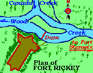
Description: Fort Rickey: 1759, Oneida County. Built Jul-Dec 1759 as a post at West Canada Creek and Wood Creek junctions for 50 troops. A t-shaped fort of 80' by 30' in its main section. Basically an outpost of Fort Stanwix at the Wood Creek carry point and dam. In ruins by 1776.
County: Oneida County
City, State: Utica, NY
Image:
See Also:
Riverview Atlas
Full History >>
Description: Riverview ATLAS F, Site #7: 1961-65, Franklin County, Riverview. See ATLAS F for detailed information.
County: Franklin County
City, State: Riverview, New York
See Also:
Robinson Barracks
Full History >>
Description: Robinson Barracks: 1860s, Chemung County, Elmira. Temporary Civil War Installation. See also Post Barracks, and Camp Rathburn, looking for more information on location.
County: Chemung County
City, State: Elmira, New York
See Also:
Rockaway Naval Air Station (NAS)
Full History >>
Description: Rockaway Naval Air Station (NAS): 1917-1930, Kings County, Rockaway Penninsula. NAS Rockaway was one of the US Navy's original Naval Air Stations. Operational from 1917 to 1930 with a maximum occupancy of 1,285. Once contained over 80 buildings on a 96 acre site. By 1930, 42 of 51 remaining structures were demolished. About 1931 started conversion to Jacob Riis Park. Completion of the park removed all traces of the air base. Starting point for first airplane to fly the Atlantic in 1919.
County: Kings County
City, State: Rockaway Peninsula, Queens, New York
Rocky Point (NY-25) Nike Base
Full History >>
Description: Rocky Point (NY-25) Nike Base:1957-74, Suffolk County, Brookhaven, Rocky Point. Integrated Fire Control for launchers at Brookhaven. Located between Wading River Manor Road and NY Route 46, South of NY Route 25A. Easternmost of the NY Defense Area contained multiple radar systems, ACQR, LOPAR, ABAR, HIPAR, and reserve radar integration system. Defended nuclear research at Brookhaven National Laboratories, Gruman's Calverton test facility and Suffolk County AFB. See also NIKE.
For more information see alpha.fdu.edu/~bender/NY25.html
Thanks to Ronald Pennisi for information on the correct closing date.
County: Suffolk County
City, State: Brookhaven, New York
See Also:
Rome Air Depot
Full History >>
Description: Rome Air Depot: 1941, Oneida County, Rome. Became Griffiss AFB, see Griffiss AFB
County: Oneida County
City, State: Rome, New York
See Also:
Rome Air Development Center
Full History >>
Description: Rome Air Development Center: 1951, Oneida County, Rome. Part of Griffiss AFB, see Rome Laboratory.
County: Oneida County
City, State: Rome, New York
See Also:
Rome Arsenal
Full History >>
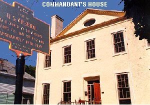
Description: Rome Arsenal: 1813-1873, Oneida County, Rome. US Arsenal, magazine, workshop, and Officers' Quarters built in 1813 during the War of 1812. Layout of the arsenal shows the road to Sacketts Harbor, now West Dominick Street, dividing the Commandant's house from the barracks and arsenal. Site was three acres. Commandant's house has been restored. The balance of the site is now commercial use buildings, some may be from arsenal period. A location just west between Arsenal Street and Wood Creek was the site of 1756 Fort Newport in the French and Indian War.
County: Oneida County
City, State: Rome, New York
Image:
See Also:
Rome Laboratory
Full History >>
Description: Rome Laboratory: 1990, Oneida County, Rome. Part of Griffiss AFB.
Get history of Laboratory on-line at www.rl.af.mil/History/rl-brief-history.html.
County: Oneida County
City, State: Rome, New York
See Also:
Roosevelt Field
Full History >>
Description: Roosevelt Field: Hempstead Plains, Long Island. A World War I airfield, 1917. Originally Hazelhurst, renamed in 1918, in honor of Quentin Roosevelt, son of TR killed in combat. (other sources say the airfield was opened adjacent to (East of) Hazelhurst Field.) Civilian field after WWI. The fields were merged and renamed Roosevelt Field in 1929. The Eastern part closed in 1935 and the remainder in 1951. Adjacent and to the South was Mitchel Field.
County: Nassau County
City, State: Hempstead Plains, Long Island, New York
See Also:
Rose, Camp
Full History >>
Description: Camp Rose: 1917-1919, Westchester County, Croton Reservoir. World War I encampment of New York Guard First Provisional Regiment near "Pines Bridge". Used while guarding New York City water supply
County: Westchester County
City, State: Croton Reservoir, New York
Roslyn Air Base
Full History >>
Description: The following information was provided by MgSgt Jan Klebukowski, 213th Education and Training Manager:
Roslyn ANG station was once a part of the 230 acre estate of Clarence Mackay. The property's first military use came during World War II, when the U.S. Government leased part of the estate as an Air Defense Post of the First Fighter Command. Later, from 1948 until 1959, the site was the home of the 26th Air Division's Air Defense Control Center - which controlled the entire Northeast. During this period it was known as the Roslyn Air Force Station. Formal title to the site changed hands in 1953, when the U.S. Government paid the sum of $250,000 for the current 50 acres. The station was owned by the USAF until the year 2000, when the land was turned over to the local community as a result of the 1995 Base Realignment and Closure commission (BRAC), and the remaining units will be relocated. Since 1959 New York State had a lease on the station for its use as a Communications and Electronics Training site for the Air National Guard. Perhaps the largest and finest non-flying station in the ANG, Roslyn had over 30 buildings, including a Vehicle Maintenance shop, AGE Shop, warehouse, and dining hall. In it's heyday, living space was maintained for as many as 80 people in private and semi-private rooms.
County: Nassau County
City, State: East Hills, Long Island, New York
Related Links:
Royal Blockhouse
Full History >>
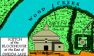
Description: Royal Blockhouse: 1759, Oneida County, Town of Sylvan Beach. Wood Creek at Eastern end of Lake Oneida. Two story blockhouse with third story watch tower. Surrounded by large earthworks. Abandoned about 1764. Same as Verona Royal Blockhouse entry.
[Description of image]
Sketch of the blockhouse at the east of Oneida Lake.
County: Oneida County
City, State: Sylvan Beach, New York
Image:
See Also:
Royal, Magazin'
Full History >>
Description: Royal Magazin': 1719, Niagara County. Another name for Joncaire's Blockhouse or Fort Joncaire.
County: Niagara County
City, State: Niagara Falls, New York
See Also: