Albany, Fort
More >>
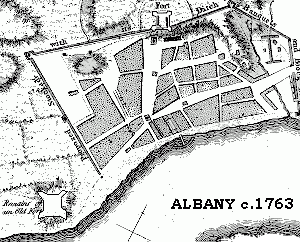
Description: Following the conquest of New Netherland in 1664, the territory that would later become New York State was ceded to the English. To maintain peace in Albany, Fort Frederick was constructed in 1676 to replace the then decaying Fort Orange. Fort Frederick, also known as Fort Albany in the 1936 novel, Drums Along the Mohawk, was named for the Prince of Wales, Frederick Louis. Strangely, the prince was not born until 1707, decades after the initial construction.
Submitted by Cliff Lamere, Albany, NY:
"I have only heard of two dates for dimantling the fort; 1784 which is before the Common Council decision to tear it down, and 1789...We know that the land on which the fort rested was deeded to St. Peter's Episcopal Church in 1790"
County: Albany
City, State: Albany, NY
Conflict/Time Period: Revolutionary War
Image:
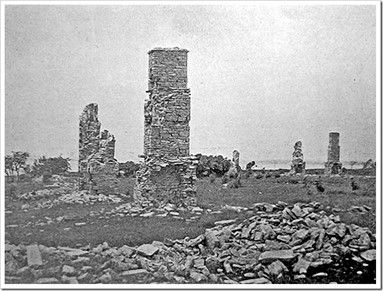
Image Set:

See Also:
“Albany Chronicles, a History of the City Arranged Chronologically, from the Earliest Settlement to the Present Time; Illustrated with Many Historical Pictures of Rarity and Reproductions of the Robert C. Pruyn Collection of the Mayors of Albany, owned by the Albany Institute and Historical and Art Society; : Reynolds, Cuyler, b. 1866 : Free Download, Borrow, and Streaming.” Internet Archive, Albany, N.Y. : J. B. Lyon Company, Printers, 1 Jan. 1970
Alden, Fort
More >>
Description: Fort Alden, 1778, Otsego County, Cherry Valley. Stockade existed and was destroyed in French and Indian War. Replaced Fort Campbell named for Commander of Continental troops there. Named for its first Commander Col. Ichabod Alden it was a stockade with possibly two blockhouses. Attacked 11 Nov 1778 and again April 1780 when the fort was destroyed. Site now marked by monument in Cherry Valley Cemetery.
County: Otsego County
City, State: Cherry Valley, New York
Conflict/Time Period: Revolution
See Also:
Amboy Ferry Post
More >>
Description: Amboy Ferry Post, 1777, Staten Island. British fortifications on southwestern shore of Staten Island and garrisoned by three companies.
County: Richmond
City, State: Staten Island, NY
Conflict/Time Period: Revolutionary War
Amersfort Blockhouse
More >>
Description: The Amersfoort Blockhouse was a Dutch fortification founded in 1630 and decommissioned in 1664. It was located in the flatlands of Brooklyn, in Kings County, New York. It is likely named for the Dutch city of Amersfoort, founded in 1259.
County: Kings
City, State: Brooklyn, New York City, NY
Amherst, Fort (1)
More >>
Description: Fort Crown Point was constructed in 1759 adjacent to Lake Champlain, in Northern New York, on the border with what would later become Vermont. The fort is often incorrectly referred to as “Fort Amherst”, as the facility was constructed under the command of Sir Jeffery Amherst of England. However, this name was never used until far after the fort was abandoned in 1780. The best-preserved remains of the fort are its stone barracks. Fort Crown Point was designated as a National Historic Landmark in 1968. The fort was also visited by various Founding Fathers, including Benjamin Franklin, George Washington, Thomas Jefferson, and James Madison.
County: Warren County
City, State: Queensbury, New York
Image:
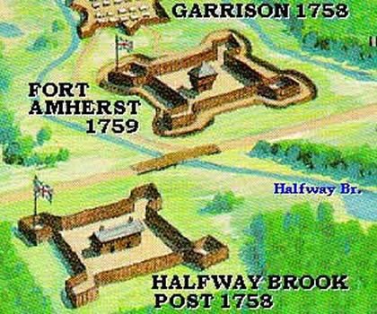
Image Set:


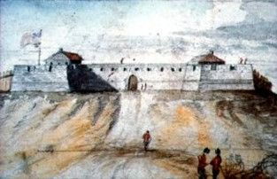
Amherst, Fort (2)
More >>
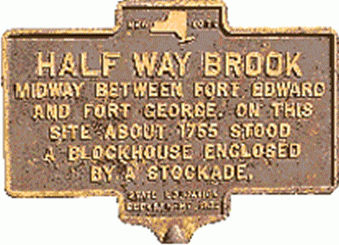
Description: Fort Amherst, initially called “Fort Miller”, was constructed in 1759 by the British just north of Glenn Falls, and close to what is now Lake George in Warren County, New York. It was demolished in 1760 and rebuilt fifteen years later by American soldiers just a year prior to the Revolutionary War. In 1777, Hessians, German soldiers who fought on the side of the British during the Revolution, occupied the fort. In 1780, Fort Amherst met its end after being brought to the torch by British forces.
Notes:
- The fort was located at the halfway point between Fort Edward and Fort William Henry/Fort George.
- The fort was once a fortified camp between 1757 and 1758.
- Also near this site was a stockaded enclosure known as Seven-mile post, or Halfway Brook Post, from 1755 to 1776, and a stockaded Garrison in 1758.
County: Warren County
City, State: Queensbury, New York
History:
Image:
Amityville Nike Base
More >>
Description: Amityville Nike Base (NY-24), 1957-74, Suffolk County, Amityville. Launcher Area for 30 Nike-Ajax Missiles, later converted to 18 Nike-Hercules Missiles, Integrated Fire Control area was Farmingdale. Inactivated 1974. Site on Farmingdale Road, now Zahn Airport, the launch area is a Reserve Center with the missile pits cemented over for a motor pool. All buildings and double fence intact.
For more sites see NIKE and for more information see alpha.fdu.edu/~bender/NY24.html (Link will open new window.)
County: Suffolk County
City, State: Amityville, New York
See Also:
Amsterdam, Fort
More >>
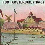
Description: Fort Amsterdam was constructed by the Dutch West India Company in 1626 on the southern end of the island of Manhattan. It served as an administrative hub for the Dutch, specifically the Dutch West India Company, and later fell under control of the British after the conquest of New Netherland in 1664. The fort remained in operation for an incredible 164 years but was torn down by the United States in 1790. The fort was involved in many famous battles and wars such as the Battle of Long Island, the Second and Third Anglo-Dutch Wars, and the American Revolution.
Notes:
- The British renamed the fortification "Fort James" in August of 1664. It maintained this name until 1687-1703 when it was renamed once again, then being known as "Fort George".
- The fort was briefly reoccupied by the Dutch in 1673 to 1674, during which time it went by the name "Fort Willem Hendrick".
- The fort is located on the site of what is now the Old Custom House at the foot of Broadway.
County: New York County
City, State: New York City, NY
Related Links:
Image:
Anne, Fort
More >>
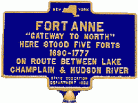
Description: Fort Anne (1), 1711, Washington County, Village of Fort Ann. On the major land route from the Hudson (Fort Edward southern terminus) to forks of Wood Creek (northern terminus) and access to Lake Champlain. Site was first occupied as a fortified camp in 1690 on the way to invade Canada in King William's War, then again in 1692 during another expedition. Queen Anne's war started in 1702 and the site was fortified as Fort Schuyler in 1709 and destroyed the same year. Rebuilt in 1711 as Queen's Fort (2) and then renamed Fort Anne. Both of these were 140 foot square palisades with interior earth fill, two large interior buildings, and 20 foot square bastion on each corner. . Restored again in 1757 and used in the French and Indian War, with the addition of stone arsenal and magazine. Mud Fort, 1769 was nearby in suburb or Needhamville. Used as a temporary Headquarters of Gen Schuyler in 1777. Located on Burgoynes route to Saratoga in 1777 and location of sawmill for Arnold's Lake Champlain Fleet. Destroyed upon withdrawal when Burgoyne reached Skenesboro. Another fort was erected after the Battle of Saratoga but was surrendered and burned in Oct 1780. A reconstruction of a blockhouse from original plans was done in 1954 as a tourist stop, and is now a bank.
For more information see www.adirondack.net/TOWNS/FortAnn/
Fort Anne (2), 1703, New York City. See Fort George.
County: Washington County
City, State: Fort Ann, New York
Image:
Anti-Motor-Torpedo-Boat Batteries
More >>
Description: AMTB #11 Battery, 1941-1949, Miller Field, Staten Island. The Anti-Motor-Torpedo-Boat (AMTB) 90mm gun M1 on mount M3 was developed in 1941 to provide a weapon that was effective against fast torpedo boats, aircraft, and land targets. It could be controlled manually or automatically through a remote control system. A protective shield was installed around the gun and allowed crew access and gun loading through the rear.
AMTB #12 Battery, 1941-1949, Swinburne Island, NY (adjacent to Hoffman Island in the Narrows). The Anti-Motor-Torpedo-Boat (AMTB) 90mm gun M1 on mount M3 was developed in 1941 to provide a weapon that was effective against fast torpedo boats, aircraft, and land targets. It could be controlled manually or automatically through a remote control system. A protective shield was installed around the gun and allowed crew access and gun loading through the rear.
AMTB #19 Battery, 1941-1949, Norton Point (Western tip of Coney Island, Brooklyn). The Anti-Motor-Torpedo-Boat (AMTB) 90mm gun M1 on mount M3 was developed in 1941 to provide a weapon that was effective against fast torpedo boats, aircraft, and land targets. It could be controlled manually or automatically through a remote control system. A protective shield was installed around the gun and allowed crew access and gun loading through the rear.
AMTB #21 Battery, 1941-1949, Kings Co., Fort Tilden. The Anti-Motor-Torpedo-Boat (AMTB) 90mm gun M1 on mount M3 was developed in 1941 to provide a weapon that was effective against fast torpedo boats, aircraft, and land targets. It could be controlled manually or automatically through a remote control system. A protective shield was installed around the gun and allowed crew access and gun loading through the rear. The AMTB Battery at Rockaway Point, also known as Breezy Point, was not located inside Fort Tilden, but at the tip of the Rockaway peninsula. This gun battery protected the entrance to Jamaica Bay. Battery #20, consisting of two 3-inch guns Model 1902 mounted on barbette carriages Model 1905 was also located in this vicinity.
County: Richmond County; Kings County; Queens County
City, State: Staten Island, NY; Swinburne Island, NY; Brooklyn, NY; Breezy Point, NY
See Also:
Arnold, Fort
More >>
Description: Fort Clinton, originally named for perhaps history’s most infamous traitor, Benedict Arnold, was constructed during the Revolutionary War in 1780. During the construction, the fortification was under the supervision of Colonel Tadeusz Kościuszko. The fort was built near what is now West Point, in Orange County, New York.
In the aftermath of the Revolutionary War, the fort was left to decay before being demolished toclear space for the expansion of the United States Military Academy founded nearby in 1802. Today, some remnants of Fort Clinton, such as the stone foundation remain visible.
Notes:
- The fort's construction started during February of 1778.
- The structure was located opposite Constitution Island.
- The fort served as the west anchor of the 1778 West Point chain.
County: Orange County
City, State: West Point, New York
See Also:
Arnot Barracks
More >>
Description: Arnot Barracks, 1860s, Chemung County, Elmira. Used as a Civil War POW Camp.
County: Chemung County
City, State: Elmira, New York
Arthur, Camp
More >>
Description: Camp Arthur, 1862, Staten Island. Civil War Training Camp.
County: Richmond County
City, State: Staten Island, New York
Conflict/Time Period: Civil War
Branch:
Atlas Sites
More >>
Description: Atlas Sites, 1961, a 12-missile Atlas F ICBM squadron (the 556th Strategic Missile Squadron) became operational 1 October 1961 at Plattsburgh AFB, NY,. The Atlas Fs were removed from alert on 25 June 1965. Ten of these 12 sites are in New York State, the other two in Vermont. The New York sites were at (1) Champlain, (4) Willsboro, (5) Lewis, (6) Au Sable Forks, (7) Riverview, (8) Redford, (9) Dannemora, (10) Brainardsville, (11) Ellenburg Depot, and (12) Mooers. The first Atlas F missile system was built in 1960, after a short operational period, was decommissioned in 1965. These sites were the first of the "super hardened"; missile silos, built to withstand a 200 pound per square inch blast. There is one reported in Saranac Lake area not listed in official records.
General Layout: These sites consist of several general elements: Command Building: Two stories 40 feet in diameter. Access was by stairs and through two blast proof doors. Approximately 2,363 square feet of floor space not including stairway or vestibule. Due to the insulation of the earth, heating and cooling needs were minimal.
Missile Silo: The missile silo was a huge structure 50 feet in diameter and approximately 185 feet deep. Access was from a 40 foot tunnel leading from the command building stairway. Missile silo had an approximate volume of 363,062 cubic feet.
Land: Land typically was 19-21 acres. Originally, the inner 5 acres of these sites were surrounded by a barbed wire topped chain link fence.
Status: All sites are now in private ownership, all materials were salavaged before they were sold but the structures remain intact as last reported in 1996.
For more Infomation go to www.siloworld.com
County: Clinton County
City, State: Plattsburgh, New York
Au Fer, Fort
More >>
Description: Fort au Fer was constructed by British forces in 1775 on the coast of Lake Champlain, in Northern New York. Bizarrely, the fort remained under British control until 1796. In 1794, the United States and Great Britain came to an agreement (the Jay Treaty of 1794) to settle a wide variety of ongoing issues, including the British occupation of forts in Northern New York. After falling under American control, the fort eventually fell victim to a fire in 1805 and was destroyed.
Notes:
- The fort was located one mile south of Rouses Point
- A large stone house from 1770 was fortified with cannon and entrenchments in 1775, with additional brick barracks and stockade.
County: Clinton County
City, State: Lake Champlain, New York
Au Sable Atlas
Augusta, Fort
More >>
Description: Fort Augusta, 1755, Orange County, Port Jervis vicinity. A fort from the Colonial Wars on the Delaware River.
County: Orange County
City, State: Port Jervis, New York
Augustus, Fort William
More >>
Description: Fort Lévis, eventually known as Fort William Augustus, was constructed by the French in 1759, and seized by the British in 1760 during the Seven Years’ War. The fort was originally named after French Marshal, François Gaston de Lévis, and rebranded by the British in honor of then head of the British Army and Duke of Cumberland, Prince William Augustus. The French constructed the fort near Ogdensburg, New York on an island surrounded by the St. Lawrence River. It was built for the purpose of supporting the existing Fort de La Présentation as a means to bolster a potential defense against possible British attacks on the area. However, this plan failed, and shortly after the fort’s seizure by the British, it was briefly maintained until its abandonment in 1766.
County: St. Lawrence County
City, State: Ogdensburg, New York
Related Links:
Aurania Stockade
More >>
Description: Aurania Stockade, 1624, Rensselaer County, Rensselaer. Stockaded village of French Protestants located near later Fort Crailo.
County: Rensselaer County
City, State: Rensselaer, New York
See Also: