Paris, Fort
More >>
Description: Fort Paris: 1777, Stone Arabia, Montgomery County. A strong palisade with a blockhouse on the western side, enclosing the 1737 house, farm, outbuildings, and trading post of Isaac Paris, with barracks for 100. Site is 3/4 miles east of Route 10 between County Routes 33 and 34.
[Description of Image]
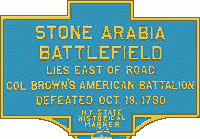
Stone Arabia
Battlefield
Lies east of road
Col. Brown's American Battalion
Defeated Oct. 18, 1780
City, State: Stone Arabia, Montgomery County
Image:
Pentagon, Fort
More >>
Description: Fort Pentagon: 1756, Oneida County, Rome. More commonly called Fort Craven. French and Indian War, On the Oneida Carry/Portage (Rome). Construction started June 1756. A pentagon shaped fort just south of Fort Williams to replace it. Major earthen fortifications 9 feet wide and timber faced. Three of five bastions were completed. Destroyed by British 20 Aug 1756 after French took Fort Oswego. See map at Oneida Carry.
County: Oneida County
City, State: Rome, New York
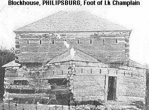
Philipsburg Blockhouse
More >>
Description: Philipsburg Blockhouse: Picture from early 1900's of what appears to be an original structure claimed located at the foot of Lake Champlain. No maps show location, may be after Philip Skene or another name for Skenesboro (as Skene had sided with the British, Skenesboro may also have been known as Philipsburg before being named Whitehall). A blockhouse is mentioned as being constructed within the old fort at Skenesboro in 1812 which could be this one.
[Description of Image]
Philipsburg Blockhouse, Foot of Lake Champlain
County: Washington County
City, State: Whitehall, New York
Image:
See Also:
Pike, Fort
More >>
Description: Fort Pike: 1812-1815, Jefferson County, Sacketts Harbor. Hastily prepared earthen works named Fort Volunteer were established at the start of the War of 1812 to defend the Northeast end of Sacketts Harbor (East side of Black River Bay). A new set of breastworks and a blockhouse were constructed adjacent and named for General Zebulon M. Pike. Included a 2 story blockhouse with 20 cannons, and barracks for 2,000. Later, Volunteer and Pike became the nucleus of Madison Barracks. See map at Sacketts Harbor Forts.
County: Jefferson County
City, State: Sacketts Harbor, New York
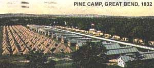
Pine Camp
More >>
Description: Pine Camp: In 1907 the Black River Great bend area was first used by the NY Guard for summer maneuvers as Camp Hughes. In 1908, Brigadier General Frederick Dent Grant, son of General Ulysses S. Grant, was sent there with 2,000 regulars and 8,000 militia. He found Pine Plains to be an ideal place to train troops. The following year money was allocated to purchase the land and summer training continued there through the years. With the outbreak of WWII, the area then known as Pine Camp was selected for a major expansion and an additional 75,000 acres of land was purchased. By Labor Day 1941, 100 tracts of land were taken over. Contractors then went to work, and in a period of 10 months at a cost of $20 million, an entire city was built to house the divisions scheduled to train here. Eight hundred buildings were constructed; 240 barracks, 84 mess halls, 86 storehouses, 58 warehouses, 27 officers' quarters, 22 headquarters buildings, and 99 recreational buildings as well as guardhouses and a hospital. The three divisions to train at Pine Camp were General George S. Patton's 4th Armored Division (Gen. Creighton Abrams was a battalion commander here at the time), the 45th Infantry Division and the 5th Armored Division. The post also served as a prisoner of war camp. Pine Camp became Camp Drum in 1951.
See Fort Drum and Camp Drum for continuation.
For more information see www.drum.army.mil/sites/about/history.asp
[Description of Image]
Pine Camp, Great Bend 1932
[Description of Image]
New Pine Camp, 1941
County: Jefferson County
City, State: Fort Drum, New York
Image:
Pitt, Fort
More >>
Description: Fort Pitt: 1776, New York City. A stong circular redoubt with 8 guns, at the intersection of Grand and Pitt Streets lower east side. This was the left flank (east) of a line to the west between Grand and Broome Streets to Broadway (Fort Bunker Hill), then northwest to a redoubt (unnamed) at Thompson and Spring Streets. Another account has the Americans constructing Crown Point Battery on Corlear's Hook, which the British rebuilt as Jones Hill Fort. This location is also given as north of intersection of Broome and Pitt Streets or Grand and Columbus Streets. The British also fortified the line of Grand Street to the west with batteries added at Norfolk Street and Eldridge Street.
County: New York County
City, State: New York City, New York
Plain, Fort
More >>
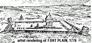
Description: Fort Plain: Revolutionary War, also known as Fort Rensselaer. South side of Mohawk River near village of Fort Plain. Built in 1776 under the direction of Col. Dayton. The fort was an irregular quadrangle with two small blockhouses on opposite corners. The stockade enclosed a large blockhouse (an existing structure) and two barracks. A larger octagonal blockhouse was built in 1780-81. Said to have been the center of a circle of 10 forts. Approached Aug 1780 but not attacked. Razed several years after 1783. Picture is a rendering of a planned reconstruction project. Fort Plain was a major American Headquarters late in the Revolutionary War, after the evacuation of Fort Stanwix (Schuyler).
[Description of first image]
Artist rendering of Fort Plain, 1776
[Description of second image]
Villefranche's drawing for the building of the
1872 Fort Plain Blockhouse
[Description of third image]
Marker on Left:
Fort Plain
1776+1788
Northern limit of raid by Brant's Indians-Tories
16 killed 60 captured
100 buildings burned
Aug. 2, 1780
[Description of fourth image]
Marker on Right:
Fort Plain
Museum
Site of
Revolutionary War Fort and Blockhouse
1780 - 1783
National Register Historic Site
County: Montgomery County
City, State: Fort Plain, New York
Image:
Plank, Fort
More >>
Description: Fort Plank: 1777, Fort Plain, Montgomery County. Not the Fort Plain (Fort Rensselaer) . Fort Plank was 2 1/2 miles northeast of Fort Rensselaer. A palisaded house of Frederick Plank, with blockhouses in the corners. Attacked several times but not destroyed. No evidence remains.
County: Montgomery County
City, State: Fort Plain, New York
Plattsburgh Air Force Base
More >>
Description: Plattsburgh Air Force Base: Authorized 1953. Involved a large expansion to the South and west (from the Saranac River on the North to the Salmon River on the South). In the 1960s hosted the 56th Strategic Missile Squadron that included the first Atlas ICBM silos (12) (see Atlas F and Champlain, Mooers, Ellenburg Depot, Brainardsville, Dannemora, Redford, Au Sable Forks, Lewis, and Willisboro). Was a Strategic Air Command bomber base for flying the polar routes initially using B-47s in 1956, and then B52s, and later FB111s, until listed for base closure in 1993.
County: Clinton County
City, State: Plattsburgh, New York
Plattsburgh Arsenal
More >>
Description: Plattsburgh Arsenal: 1810, Clinton County, Plattsburgh. Consisted of an arsenal, blockhouse, armory, hospital and cantonment area near the Fredenburgh Falls on the Saranac River, about 2 miles in from the lake, presently Broad Street. Destroyed in Battle of Plattsburgh July 30, 1813
County: Clinton County
City, State: Plattsburgh, New York
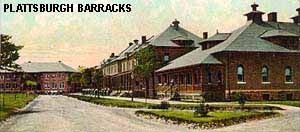
Plattsburgh Barracks
More >>
Description: Plattsburgh Barracks: Sometime following the War of 1812, 40 log barracks were built within the pentagon complex formed by Forts Brown, Moreau, Scott, Gaines and Tompkins. Later three stone barracks were constructed on a military post South of this complex. Earliest found Postcards are from 1905.
This area between the Saranac River and Lake Champlain then went through a series of changes as follows:
Plattsburg Training Camp: Starting in 1917 it was the site of the "Plattsburgh Idea," a military officer training camp that was the forerunner of ROTC. This was also refered to as the Plattsburgh Military Camp and the Citizen's Military Training Camp, and also remained the U.S. Army Barracks.
Plattsburgh Naval Officers Training Camp - 1944.
Plattsburgh Army Air Force Convelescent Hospital - 1945
Champlain College - 1946, for returning servicemen.
Further Reading
Clute, Penelope D. "The Plattsburg Idea," New York Archives. v5 n2 (Fall 2005) 8-12
Part One - ** Large File Size 700k
Part Two - ** Large File Size 560k
This article first appeared in the Fall 2005 issue of New York Archives magazine. It is reprinted here with permission from the Archives Partnership Trust, www.nysarchives.org
County: Clinton County
City, State: Plattsburgh, New York
Image:
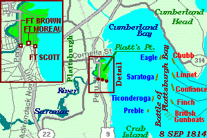
Plattsburgh Battle Forts
More >>
Description: Plattsburgh Battle Forts: 1814, Clinton County, Plattsburgh. On September 8, 1814, Capt.Downie (killed by early shot) of the British Navy engaged an American fleet under Lt. MacDonough in the Battle of Plattsburgh Bay. At the same time British troops advancing down the Beekmantown Road and along the lake under Gen Provost attempted to cross the Saranac River into Plattsburgh. Americans under Gen Macomb defended Platt's Point with three forts (Brown, Moreau and Scott) between the Saranac and the Lake, and breastworks at bridge sites made from blown-up bridges. Additionally three blockhouses guarded the river's mouth. The British land attack lasted 2 1/2 hours until the British fleet was defeated, and the British retired to Canada. In 1814, after the battle, two additional forts were constructed. Fort Tompkins south of Brown, and Fort Gaines south of Scott. This created a pentagon shapped complex when connected by curtain walls. Forty log barracks were later constructed within the complex which later became Plattsburgh Barracks.
County: Clinton County
City, State: Plattsburgh, New York
Image:
See Also:
http://www.historiclakes.org/towns/plattsburgh_gallery.htm
For more information see www.historiclakes.org/Plattsburgh/Plattsburgh.html [link opens new window]
Plumb Point, Fort
More >>
Description: Fort Plumb Point: 1777, near New Windsor, Orange County. A redoubt with 14 guns on Plumb Point north of the intersection of Murder's Creek and the Hudson River. Also known as Machin's Battery - Capt. Thomas Machin was entrusted with the construction of fortifications on the Hudson River to prevent the British advance up the Hudson River. This redoubt was three miles north of West Point and guarded the west end of a Chevaux-de-frise that ran east to Pollopel's (Bannerman's) Island, with an unnamed battery on the Island and another fort south of the Fishkill Creek was part of the Fishkill Barracks and included three gun batteries.
County: Orange County
City, State: New Windsor, New York
See Also:
Plume, Camp Joseph W.
More >>
Description: Camp Joseph W. Plume: July-Aug 1891, Erie County, Buffalo. 202nd Regiment NY Volunteers organized and mustered at camp for Spanish-American War then went to Camp Black. Location not known, possibly near 65th Regimental Armory.
County: Erie County
City, State: Buffalo, New York
Poinsett Barracks
More >>
Description: Poinsett Barracks: 1839-1845, Erie County, Buffalo. Originally called Buffalo Barracks also known as Poinsett for Secretary of War Joel Poinsett. Constructed to house troops in the area due to tensions with Canada from the Patriot's War. Leased area bounded by Main, Allen, Delaware and North Streets in October 1939. The majority of buildings surrounded a rectangular parade grounds on the Northern end of the Post by December. Mid 1840 three Officer's Quarters, known as the Theodore Roosevelt Inaugural Site, were erected along Deleware, one remains. After completion of nearby Fort Porter, the post was redundant, and closed in September 1845.
For more information see also www.buffalonet.org/army/
County: Erie County
City, State: Buffalo, New York
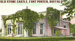
Porter, Fort
More >>
Description: Fort Porter: 1841-44, Erie County, Buffalo. Bounded by Porter Avenue, Busti Avenue and the Erie Barge Canal. Named for Gen Peter B. Porter. Initially a square masonry 2-story redoubt 62 feet square with crenelated walls. Surrounded by large earthworks and moat. It may have been one of the largest blockhouses built. The "castle" had been built in 1836 as a home for Col. James McKay. This was part of the government acquisition of land in 1841 and was used as the Commandant's Quarters.
Fort Porter had not been used for some time when Civil War started. Used as Headquarters of the 74th Regiment, NYNG. Ten 60 by 18 foot barracks were constructed and used as a recruiting center. November 1863 the blockhouse burned. In 1898 the post was reactivated for the Spanish-American War and used as Headquarters for 13th U.S. Infantry. In 1917 it was reactivated again for WW1 and used as U.S. Army Base Hospital 23 until the unit shipped out. At the close of WW1 it was used as U.S. General Hospital 4 for returning wounded. In 1926 the property was sold to provide approaches to new Peace Bridge, and all evidence was removed.
County: Erie County
City, State: Buffalo, New York
Image:
Post Barracks
More >>
Description: Post Barracks: 1860s, Chemung County, Elmira. Temporary Civil War training facility for recruits in Elmira area. Location not known. See also Camp Rathburn and Robinson Barracks.
County: Chemung County
City, State: Elmira, New York
Branch:
See Also:
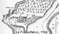
Presentation, Fort La
More >>
Description: Fort La Presentation: A fortified French mission also called Oswegatchie (now Ogdensburg) in 1749 above the rapids on the St Lawrence River at the mouth of the Oswegatchie River, on Lighthouse Point. Started as a small stone house and a small fort of pickets with one bastion/house, that was burned in a fall 1749 raid. By 1751 a new palisaded fort, 70 feet square, flanked by four bastions was built. The fort also had a wide moat and entrenchment, and an interior parapet. Captured in 1760 it was renamed Fort Oswegatchie and occupied until their evacuation in 1796. Funds were provided in 1976 for a reconstruction? See also replacement / companion Fort Levis.
County: St. Lawrence County
City, State: Ogdensburg, New York
Image:
See Also:
Prince, Fort
More >>
Description: Fort Prince (Prince Charles): 1776, Manhattan. Originally an American earthwork erected as Fort Number 9. Taken by the British November 1776 and renamed Fort Prince Charles, or Charles Redoubt. Site is on south side of Marble (Valentine's) Hill at Fort Charles (Corlear) Place and Kingston Avenue. Occupied by Hessian troops and reconstructed by them. Destroyed fall 1779.
County: New York County
City, State: Manhattan, New York
See Also:
Princess Bay Blockhouse
More >>
Description: Princess Bay Blockhouse: 1814-1815, Staten Island, Richmond County. One of several blockhouses for the defense of NY Harbor ordered by Gen Joseph Smith, Chief of Engineers. (Bath Beach, Utrecht Bay, Denyse's Heights, Princess Bay, Jamaica Bay - Decatur) Records are not clear that all of the sites were constructed.
County: Richmond County
City, State: Staten Island, New York
Putnam, Fort
More >>
Description: Fort Putnam (1): 1776, Brooklyn. From the Oblong Redoubt the American line rose northeast to a hill crest with Fort Putnam (now Fort Greene Park). A star shaped fort with five guns. Named for Col. Rufus Putnam. Held a garrison of 5 companies. One of a line of entrenchments for the Battle of Long Island from Fort Box at marshes near Gowanus Bay to Fort Greene to Oblong Redoubt to Fort Putnam to Left Redoubt at Wallabout Bay. Each work was a complete entity surrounded with a wide ditch, sides lined with pointed stakes, and each had sally-ports. Most of the line also had abatises. Left (north) at the eastern end of the hill was the last fortification of the line called Left Redoubt (Cumberland between Myrtle and Willoughby) covering the left (northern) flank. Renamed Fort Greene in the War of 1812, now site of Fort Greene Park.
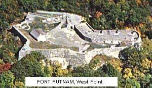
Fort Putnam (2): 1778, West Point. Fort Putnam predates USMA (1802) by nearly 25 years and was Fortress West Point's largest military fortification. Fort Putnam, which overlooks USMA and is situated northeast of Michie Stadium 500 feet above sea level, was the best position to fortify against infantry assault and helped to effectively block British travel on the Hudson during the Revolutionary War. A complete refurbishment of the fort occurred during the nation's Revolutionary War Bicentennial. Cannon and mortars were reproduced and placed according to drawings by Lt. Louis- Alexandre Berthier, a Revolutionary War topographic engineer.
For more information go to http://www.usma.army.mil/tour/.
For pictures see www.antonucci.org/photoecho/westpt.html
[Description of image]
Fort Putnam, West Point
County: (1) Kings County (2) Orange County
City, State: (1) Brooklyn, New York (2) West Point, New York
Image: