L'Observation
More >>
Description: L'Observation: 1757, French, Jefferson County, 1-1/2 miles from Six Town Point on Henderson Bay, South of Sackets Harbor. Square stockade, French military observation post.
County: Jefferson County
City, State: Henderson, New York
Lafayette, Fort
More >>
Description: (1): 1777, Huson River South of Peekskill, at Verplancke's Point. At the East end of "The King's Ferry" from Stony Point. Captured by the British in 1779 along with Stony Point. Believed abandoned by British in October 1779 along with Stony Point.For more information see http://www2.lhric.org/spbattle/spbattle.htm (link opens new window)
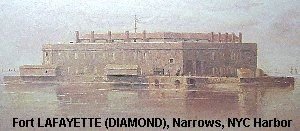
(2): 1812, New York Harbor off Fort Hamilton. Built in 1812-18 on Hendrick's Reef and armed with 72 cannon. Originally named Fort Diamond, renamed in 1825 for General Lafayette. Used for Confederate prisoners 1861-66. Burned in 1868. Transferred to the Navy in 1898 for the storage of Naval supplies and ammunition. During WW2 the fort was used as an interim storage facility and transfer point for small and miscellaneous lots of ammunition. Fort included a Marine Barracks. Transferred to NYC after the war in 1948, mostly demolished in 1960 for Verrazano-Narrows Bridge foundations.
County: 1)Westchester Countyi 2) New York County
City, State: 1)Peekskill, New York 2) New York City, New York
Image:
Laight, Fort
More >>
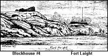
Description: Fort Laight: 1814, New York City. South side of old 125th Street (now LaSalle), North of 124th, 120 yards east of 11th Avenue (present day Morning Side Gardens). Named for Ltc. Edward Laight of the City Militia. This stone fort (probably similar to Fort Clinton at McGowan's Pass) commanded Manhattanville overlooking Harlem Plains. It also covered the Manhattanville Pass in Bloomingdale Road at 123rd street and 100 feet West of 11th Avenue (Broadway). Fort Laight also had entrenchments west through Riverside Park near Grant's Tomb to the Hudson Heights. Picture is 1877 etching by Henry Farrer. See Blockhouse #4 for 1903 photo of same view. Info credit to Eric K. Washington, The Manhattenville Heritage Society
County: New York County
City, State: New York City, New York
Image:
See Also:
Lancaster Nike Base
More >>
Description: Lancaster Nike Base (BU-18): 1956-1970, Integrate Fire Control Area for Nike-Ajax Missiles, associated Launcher area was Milgrove. For more pictures see www.pcpages.com/phoneman/bu18.html (link opens new window)
County: Erie County
City, State: Lancaster, New York
See Also:
LaSalle, Fort
More >>
Description: Fort LaSalle: 1669, Niagara County, Youngstown. Temporary fort built by LaSalle as overwinter quarters, probably defensible from attack, on the site of the future Fort Niagara. Destroyed by the Senecas in 1675. Next fort on the site was Fort Conti in 1679.
County: Niagara County
City, State: Youngstown, New York
See Also:
Lawrence, Fort
More >>
Description: Fort Lawrence: 1814, Brooklyn, West side of Gowanus Creek, Junction of DeGraw and Bond Streets. Battery of Artillery position.
County: Kings County
City, State: Brooklyn, New York
Levis, Fort
More >>
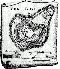
Description: Fort Levis: 1759, Isle Royal (Chimney Island), St. Lawrence River, St. Lawrence County. Determining that Fort La Presentation was not strong enough to defend the St. Lawrence River the French constructed Fort Levis on Isle Royal (Chimney Island) three miles downstream. Named for their commander de Levis it was a four bastioned square, built of wood. Destroyed in three days of bombardment in 1760 by General Amherst it surrendered August 25, 1760. Rebuilt as Fort William Augustus. Some reports indicated the island was obliterated in construction of the St. Lawrence Seaway, however some of the island apparently remains. More information is sought on any remains.
County: St. Lawrence County
City, State: St. Lawrence River, New York
Image:
See Also:
Lewis Atlas F
Lewis, Fort
More >>
Description: Fort Lewis: 1814, Kings County, Brooklyn. A blockhouse and earthworks of 30 guns on Denyse Heights near the future site of Fort Hamilton. See also Denyse's Heights Blockhouse 1813.
County: Kings County
City, State: Brooklyn, New York
See Also:
Lido Beach Nike Base
More >>
Description: Lido Beach Nike Base (NY-29/30): 1955-63, Launchers and Integrated Fire Control Area for 60 Nike-Ajax Missiles. For more information see NIKE and http://alpha.fdu.edu/~bender/NY29.html (link opens new window)
County: New York County
City, State: New York City, New York
See Also:
Light Infantry Redoubt
More >>
Description: Light Infantry Redoubt: 1759, Crown Point. Light Infantry of Regiments Redoubt is outworks to the South East (land side) of Fort Crown Point. See Fort Crown Point.
County: Essex County
City, State: Crown Point, New York
See Also:
Lispenard's Redoubt
More >>
Description: Lispenard's Redoubt: 1776, New York City. Started as American works on Lispenard's Hill as the western anchor of a defensive line. Was a redoubt covering north and had a battery covering the Hudson (Grenadier's Battery reconstructed by British in 1780 into Foundry Redoubt). Near present Varick and Laight Streets. 1780, the landward fort was rebuilt into a star shaped works and renamed Star Redoubt.
County: New York County
City, State: New York City, New York
Little Niagara, Fort
More >>
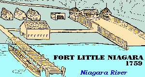
Description: Fort Little Niagara: 1750, Niagara County, Niagara Falls. A small blockhouse and storehouse was first errected in 1745 at a location known as "Frenchman's Landing." In 1751 the upper end of the portage from Fort Niagara was moved a few hundred yards South and Fort Little Niagara or Fort du Portage was constructed. Consisted of three good sized blockhouses with palisades between them and the river. Destroyed when abandoned in 1759 at the approach of the English. Rebuilt by British as Fort Schlosser in 1760.
County: Niagara County
City, State: Niagara Falls, New York
Image:
See Also:
Little Stone Arabia, Fort
More >>
Description: Fort Little Stone Arabia: 1776, Frankfort. Small stockade, no other information on this fort, may be Fort Keyser or Fort Paris.
County: Herkimer County
City, State: Frankfort, New York
See Also:
Lloyd Harbor Nike Base
More >>
Description: Lloyd Harbor Nike Base (NY-20): 1957-63, Suffolk County, Lloyd Harbor. Integrated Fire Control area. Inactivated 1963. Three Magazine Nike Battery Launch site was Huntington. Sites demolished under private ownership. For more information see NIKE and http://alpha.fdu.edu/~bender/NY20.html
County: Suffolk County
City, State: Lloyd Harbor, New York
See Also:
Look Out, Fort
More >>
Description: Fort Look Out (1): Hudson River, North of Annsville Circle. A small Patriot works, covering route from bay towards Continental Village. Evacuated in October 1777 and destroyed by the British. For more information see www.dmna.state.ny.us/map/rev-war.html
Fort Lookout (2): received from John Curran, City Historian of Peekskill - "There was a "Fort Lookout" as a redoubt, lookout post and probable beacon on the highest point between Dogwood Road and Sprout Brook Road in Town of Cortlandt. The Geological Survey map cleary shows the elevation. Furthermore, an aerial map of 1986 shows a circular fromation at that same location at the top of that hill. This map is available at the Westchester County Depgooartment of Planning, made by Keystone Aeral Services in Philadelphia Pa., Spring 1986, Map citation = C-1."
County: Westchester County
City, State: Peekskill, New York
See Also:
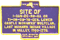
Lower Mohawk Castle
More >>
Description: Lower Mohawk Castle: 1711, Montgomery County, Fort Hunter. See Fort Hunter.
Site of I-Can-De-Ro-Ga or Ti-On-On-To-Geh. Lower Castle Mohawks' Wolfclan. Last Mohawk Indian villiage in valley, 1700-1775.
County: Montgomery County
City, State: Fort Hunter, New York
Image:
See Also:
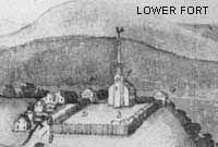
Lower, Fort
More >>
Description: Lower Fort (1): Old Stone Fort, Schoharie, 1777. Lower Fort still stands today and is used as a museum. Built as a Dutch Reformed church in 1772, its walls of Schoharie limestone made it a formidable structure. Begun in 1777 it was enclosed in a stockade containing about one acre. In 1778 blockhouses were added at the southeast and northeast corners. Huts and a tavern were constructed on the interior west side. Attacked by British, Loyalists and Indians 17 Oct 1780, not taken. The stockade was removed around 1786. Located near Schoharie Creek North of village of Schoharie.
Lower Fort (2): Fort Delaware of PA across from Cohecton,Sullivan County NY
County: 1) Schoharie County 2) Sullivan County
City, State: 1) Schoharie, New York 2) Cohecton, New York
Image:
See Also:
Lufberry Field
More >>
Description: Lufberry Field: Army Air Service Training Field, Massapequa, Long Island, World War I.
County: Nassau County
City, State: Massapequa, New York
Lydius, Fort
More >>
Description: Fort Lydius: This location was the Southern terminus of the "Great Carrying Place", a 11 mile route from the Hudson River (now Ft Edward) to the forks of Wood Creek at Fort Anne leading to Lake Champlain. Purchased and developed as a colony by John Lydius in 1732, named Fort Lydius. The settlement was destroyed in 1745. Rebuilt in 1755 as Ft Lyman.
County: Washington County
City, State: Fort Edward, New York
Image:
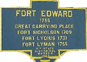
Lyman, Fort
More >>
Description: Fort Lyman: This location was the Southern terminus of the "Great Carrying Place", a 11 mile route from the Hudson River (now Fort Edward) to the forks of Wood Creek at Fort Anne leading to Lake Champlain. In 1755 General Lyman built fortifications on the ruins of Ft Lydius named Fort Lyman. Renamed Fort Edward shortly upon completion.
County: Washington County
City, State: Fort Edward, New York
Image: