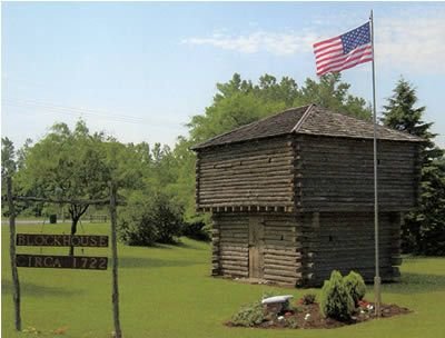
Cambria Nike Base
Cambria Nike Base (NF-16), Mid 1950s-Mid 1960s, Niagara County, Cambria. Launcher Area for Double Nike-Ajax Missile site, associated IFC area was Sanborn. Located on Upper Mountain Road and Cambria Road. Now Cambria Town Hall and vehicle maintenance. Launching area is overgrown, and barracks were converted to Elderly Apartments. For more sites see NIKE.
Campbell, Fort
Fort Campbell was built in Ostego County, near Cherry Valley, New York, in 1777. The fort’s defenses were eventually upgraded, which led to Fort Campbell being rebranded as Fort Alden in 1778. Fort Alden would be destroyed following a British assault on the fortress in 1780. Notes: - Breastworks of logs and earth surrounded the house of Major Samuel Campbell; These were replaced by stronger works as part of Fort Alden in 1778.
Canajoharie, Fort
Fort Canajoharie was built by British forces in 1747 during King George’s War, to defend a preexisting Native American castle belonging to the Mohawk tribe, who were politically aligned with the British. The original structure, built by the natives in 1710, was known as the Upper Castle of the Mohawks, and was located near what is now the town of Danube, New York. Fort Canajoharie remained in operation until it was abandoned in 1752. The fort was reestablished in 1755 during the Seven Years’ War under the name Fort Hendrick but was once again abandoned after another eight years of operation. Notes: - Fort Canajoharie spanned approximately one acre, with two blockhouses. Other estimates state that the fort could have been smaller, spanning just half an acre. - The fort was referred to as "the fort at Canajoharie" but was never officially named as such.
Canaseraga Blockhouse
Canaseraga Blockhouse, 1756, Madison County, Sullivan Hamlet (Canaserga). Blockhouse constructed under the direction of Sir William Johnson, 24 square foot base with an 18-24" second floor projection. Built for the protection of the Tuscarora Village of Canaseraga, located east of Chittenango on NYS Route 5. There is no evidence this blockhouse existed much beyond the French and Indian War. In Oct 1780, an American detachment from Ft Stanwix (Schuyler) of about 60 under the command of Cpt Walter Vrooman, was camped at the abandoned Tuscarora Village awaiting reinforcements for a raid on British positions on Lake Onondaga, when captured by British forces.
Carillon, Fort
Fort Carillon was built in 1755 under the leadership of Pierre de Rigaud, the then Governor of French Canada. The fort saw action during the Seven Years’ War and was attacked in 1758 by a massive British force comprised of 16,000 soldiers, which, at the time, was the largest ever assembled in North American military history. Commanded by Brigadier General, Lord Howe, the British were utterly decimated by French defenses, leading the fort’s garrison enjoying a total victory over their ill-prepared attackers. However, the British would return in 1759 and would successfully capture Fort Carillon, which they renamed to Fort Ticonderoga. The fort would eventually be captured by the Continental Army in the earliest stages of the Revolutionary War in 1775. Finally, Carillon was recaptured by British forces during their march to Saratoga in 1777. Today, the building still stands, operating as a tourist attraction, museum, and research facility.
Carleton, Fort
Fort Carleton, initially named for former Governor of Quebec, Sir Guy Carleton, was established in 1778 under the leadership of Captain Thomas Aubrey. The garrison was stationed in Jefferson County, New York. The fort was renamed "Fort Haldimand" for then Governor of Quebec, Frederick Haldimand. The British garrison, situated on the island of Carleton, saw combat during both the American Revolution and the War of 1812. Despite its impressive several decades of operation, the fortification was forcibly taken by American forces in June of 1812 and was subsequently destroyed.
Castle William
Castle Williams was a fortification constructed from sandstone located on Governor’s Island in Brooklyn, New York. The construction began in 1807, and the structure was completed by 1811, just before the outbreak of the War of 1812. The fort was constructed under the leadership of engineer Johnathan Williams, for whom the fort is named. Williams was the nephew of Founding Father, Benjamin Franklin. The fort, next to other structures of its time, was comparatively monstrous. At forty feet tall, and more than 200 feet in diameter, the building towered over New York Harbor. During the Civil War, the base served as a point for newly recruited Union troops to group together before their deployment to the frontlines in the American South. Following the Civil War, the castle was made into a low-security military prison. After a century of operation in this form, though, the prison was decommissioned by the United States Army. Now, the structure serves as a museum and as a venue for community events. And finally in 2003, the castle, along with its neighbor, Fort Jay, were put under new management: the National Park Service. Notes: - The castle featured a three tiered horseshoe shaped roundhouse which boasted 100 guns, was 200 feet in diameter, 40 feet high, and 8 feet thick. - Williams based the fort's structure on a French design. - Castle Williams was the first casemated fort in North America, its multi-tiered parapets provided greater firepower than earlier fort designs. - The fort held Confederate prisoners from 1862 to 1870.
Caughnawage, Fort
Fort Caughnawage, 1779, Montgomery County, Fonda. Unverified blockhouse at Sandy Flats just west of Fonda. Village was destroyed in a spring 1780 raid. The fort is reported to have been torn down after the Revolutionary War.
Champlain Atlas
Champlain Atlas F, Site #1, 1961-65, Clinton County, Champlain. See Atlas F for detailed information.
Charles Redoubt/ Fort Charles
Fort Prince Charles, also known as Charles Redoubt, constructed in 1776, was an American fortification built during the Revolutionary War located in New York City. During the British invasion of the New York, the fortification was captured and renamed from “Fort No. 9”, to Fort Prince Charles, in honor of then British Prince, Charles Edward Stuart. The fort was destroyed in 1779; no tangible remnants of the fort were left behind.
Chauncey, Fort
Fort Chauncey, 1812, Jefferson County, Sackets Harbor. Battle of Sackets Harbor 1812-15. A minor redoubt in a fortified line of 4 such "forts" (Kentucky, Virginia, Chauncey, Stark) anchored at Fort Pike on the Bay (later Madison Barracks) protecting the land side of Sackets Harbor. Named for Commodore Isaac Chauncy. Site East side of Monroe Street North of Main Street. See map at Sacketts Harbor Forts listing.
Chimney Point
Chimney Point, 1730, Vermont. Located directly opposite Crown Point, across a very narrow channel, the Chimney Point area has been occupied for at least 7,500 years. Native Americans regularly camped at the point while hunting and fishing. The French first built a stockaded fort there, Fort de Pieux (which is "fort of posts" and not a name per se) in 1730. This fort was the key French fortress in the Southern part of the lake until Ste. Frederic was built across the channel. The French called this area "Pointe a la Chevelure." The British called it Chimney Point in 1759 after a remaining French farmstead cimney.
Citizens Redoubt
Citizens Redoubt, 1776, New York County, New York City. Originally called Badlam's Redoubt this defense mounted 8 guns and was built in spring 1776. The site was high ground, Rutger's Hill, at Market and Madison Streets. After the Americans evacuated New York City, local citizens rebuilt it as Citizen's Redoubt.
Clinton, Castle
Castle Clinton, formerly known as the West Battery, was a fortification in New York City built in 1807. During the War of 1812, the fort maintained a garrison, but the base never saw combat. From 1855 to 1890, Castle Clinton served as the predecessor to Ellis Island. Over 7.5 million people entered the United States during this period. The castle, since 1986, has served as a visitor center as well as a port for ferries bound for Liberty Island. Notes: - More than half a dozen forts were built to defend the New York Harbor during the War of 1812. - Castle Clinton was constructed on the rocks off the tip of Manhattan Island. - The castle was armed with twenty-eight cannons, but never saw combat. - In 1824, the castle was converted into a restaurant called "Castle Garden". - The castle had a brief tenure as an opera house and theater, between 1840 and 1854.
Clinton, Fort - New York
Notes: - Fort Clinton was constructed in 1814. - Located in the northeast corner of what is now Central Park, near the intersection of Fifth Avenue and East 107th Street. - Hill on which the fort once stood now hosts a monument to the fortress.
Clinton, Fort - Orange County, 1777
Fort Montgomery. Construction started in January. Guarded first of the famous chains, vicinity of current Bear Mountain bridge, on West bank of the Hudson River, South of chain, South of Popolopen Creek. Companion to Fort Montgomery, to the North of the creek, captured by the British 6 Oct 1777. Renamed Fort Vaughan, destroyed and abandoned end of Oct 1777. Site at intersection of US 6 and US 9 at Bear Mountain State Park. Partially obliterated by bridge approaches.
Clinton, Fort - Orange County, West Point, 1778
Orange County, West Point, 1778 On Hudson River opposite Ft. Constitution. Originally named Fort Arnold, construction started in February and completed about Dec 1778. Renamed Fort Clinton in 1780 after Arnold's desertion to the British (The previous Clinton had been destroyed in Oct 1777). Secured the West end of the second West Point chain (Spring 1778 to Winter 1782).
Clinton, Fort - Saratoga County, Schuylerville, 1746
Saratoga County, Schuylerville, 1746 On Hudson River just South of present Schuylerville and the Fish Kill. Reconstruction of the destroyed Fort Saratoga. Attacked by French and Indians June 1747. Abandoned and burned fall of 1747. No further forts at this site, Fort Hardy was built in Schuylerville in 1755, a few miles to the north.
Clyde Blockhouse/Fort Clyde
Clyde Blockhouse, 1758, Wayne County, Town of Galen. Constructed about 1758 near the Clyde River, supposedly by "Indian Traders." This trading station was reported to have been a smuggling station from Canada during the American Revolution. A settlement grew up around the blockhouse originally known as Lauraville and then later the Village of Clyde. There is a reconstruction of the wooden blockhouse on the South side of NYS Route 31, a little East of its junction with NYS Route 414. The Village of Clyde supplied the following information. Clyde Blockhouse, 1777-1785, Wayne County. Is a replica of the Blockhouse which existed near this site in the 18th century. It was erected in 1975-1976 with money and material donated by the Parker-Hannifin Corp., and other local industries and businesses. It was built with all volunteer labor as a Town of Galen Bicentennial project. Although historians differ on facts about the Blockhouse, The Military History of Wayne County favors the account of Mr. Adrastus Snedaker, "an old and esteemed resident of Clyde. " Snedaker's information came from trappers who said the build-ing was put up on the north bank of the Clyde River, east of Vanderbilt Creek. Built during the French and Indian War. it was originally a fort of two stories, with the upper floor projecting over the lower. During the Revolutionary War, the building was used as a depot for storage of goods smuggled to and from Canada. The Blockhouse is believed to have burned prior to 1805. Taken from Morrison's History of Clyde Wayne County: Records dating back into colonial times reveal that first white men to have set their feet upon the ground that is now the VILLAGE of Clyde came early in 1722, when Governor Burnett of the Province of New-York sent an expedition into what is now the interior of the state to make a settlement or trading-post for the opening of a fur trade with the western Indians. He dispatched Lieu't. Jacob Verplank, Gilleyn Verplank, Johannis Visger, Jr.. Harmanus Schuyler, Johannis Van-den Bergh, Peter Groenandyck, and David Van der Hey-den with instructions to purchase a tract of land to be patented by those who would be the first settlers. The expedition left Albany in the spring and returned in September, establishing a post at Sodus Bay. On July 8th, a detachment of three men, Lieu't. Verplank, Harmanus Schuyler and David Van der Heyden left the post and went south into the woods led by a friendly Onondaga Indian, and within a few hours were upon the shore of a stream called Muddy Waters by the Indians, later called Mud Creek, and still later the Clyde River, They spent about a week putting up a BLOCK-HOUSE and then returned to the bay where they reported their activities. The building was two stories high, the upper projecting over the lower, at the sides and ends. In the floor of the upper story —- near the sides and ends — were the port holes, through which a volley might reach an enemy, A few days later Cap't. Schuyler received information of a plan to attack him at the bay by a party of French and Huron Indians, He left there and re-took possession of the BLOCK-HOUSE, which he prepared for its defense, remained only a week, and then went east down the river guided by the Onondaga Indians. Afterwards the structure served as a defense for many bands of Indians and whites that passed through this locality. It was used during the French and Indian War and also during the Revolutionary War by whoever happened to have possession of it. After peace had been declared between the United States and England, it was used by smugglers and marauding British soldiers until about 1800, when the Government sent soldiers to clean them out. During the fighting the building was set on fire and destroyed, It stood upon the north bank of the Clyde River and east of the mouth of Vanderbilt Creek, a little east of the old New-York Central Rail-road depot. The ground upon which the old relic stood wag a rounded elevation, sufficient to place it above the reach of high water, and was leveled off in the construction of the rail-road in 1852. In 1805, Cap't. Luther Redfield with his brother-in-law A Mr, Dryer, visited this locality. They ascended Dickson Hill, south-east of. the intersection of Mill and Redfield Streets, where they climbed a tree to take in the view, and clearly saw Lake Ontario. Descending the hill to the river, they made a raft of driftwood, and came over to the site of the BLOCK-HOUSE. It had been burned, but there were still left the charred ends of the logs at the corners — a few remains that entirely disappeared not[?] Several of the prominent citizens resolved to dig for the hidden treasure, and selecting the mid-night hour for such labor, they commenced their operations. Night after night had thus passed, when in the midst of the enthusiastic, prosecution of the enterprise, an ugly looking object appeared to them dressed in white, and of a seeming un-earthy origin. Then one of the party rushed up to the apparition with an. uplifted axe and exclaimed Be ye man or devil, I'm after you! The ghost (if such was the case) made one bound and sought quarters in some underbrush nearby, and after which time was no more seen. Many people believed that the whole party was more or less frightened, inasmuch as the money digging mania ceased from that hour. THE ABANDONED CANNON. IN September of 1779, a six-pound cannon was abandoned in the Clyde River, a little to the west of the village by Butler's Rangers from Pennsylvania on their full retreat before the victorious General John Sullivan. Butler, it appears, was a friend of the celebrated Indian warrior, Joseph Brant, one of the six nations (composed of the Mohawks, Senecas, Cayugas, Oneidas, Onondagas and Tuscaroras) none of whom were on friendly terms with the population of this section. When Butler and his Rangers found that the indomitable Sullivan was in hot pursuit and very close upon them, they sank their cannon beneath the swift rolling waters of the Clyde. Of this fact we have the testimony of men who settled in this region at an early day. John King, who was a business-man in Clyde more than a century and a quarter ago, and whose father was a genuine pioneer, said that in my 'boyhood it was currently reported among the trappers that a cannon had been sunk a little west of Clyde by Butler's men, and that raftsmen in passing through the, stream had touched it with their poles. Mae DeGolyer, another settler long since dead, and once a raftsman, used to say that I have seen Butler's cannon. It is therefore a historic fact that there is now a cannon buried, not necessarily beneath the waters of the Clyde River, for the stream may have changed its course since then, but very near and possibly on the shore of it. The uncertainty of its exact location will probably forever preclude attempts to secure the prize. When Aaron Griswold first came to Clyde in 1813, some thirty-four years after the invasion, the story of the old abandoned cannon was common talk. A. man named King claimed to know the exact location. and asserted that he had dived down and not only seen it, but had put his hand in the muzzle. No attempt was ever made at this time to recover it, but somewhere about 1840 a search was made for it, Aaron Griswold and Beriah Redfield in. the company of Mr. King, went up the river and spent some time in searching for the cannon, but failed to find it.
Cochecton Post
Cochecton Post, 1760, Sullivan County, Village of Cochecton. A stockaded blockhouse, the "Upper Fort" was on the "Jersey side" of the Delaware River, now New York State. The corresponding Lower Fort was Fort Delaware in Pennsylvania.
Cock Hill, Fort
Standing between ten and twelve feet in height, the small circular earthworks of Fort Cock Hill were constructed in 1776 during the early parts of the Revolutionary War. Situated on the Hudson River, near Harlem River Valley, the fort served to protect New York from British capture. Shortly after its construction, Fort Cock Hill was attacked by British forces, specifically German soldiers, known as Hessians, who fought under the flag of the Empire. The fort was held by British forces until the war’s end in 1783.
Cole's, Fort
Built in 1755, Cole’s Fort was constructed in what would become Orange County, New York. At the time, the area was claimed by colonial New Jersey. The fort was named for Wilhelmus Cole, who settled in the area around 1730, the construction was a fortified home. The structure featured a 120 foot palisade as well as two blockhouses.
Columbus, Fort
Built in 1794, on Governor’s Island, in New York Harbor, just 800 yards from Manhattan, Fort Jay, named for the Founding Father, and tertiary author of the Federalist Papers, John Jay, was built for the purpose of defending Upper New York Bay. Built from Revolutionary War Era earthworks, the construction was fitted with four corner bastions, and was later renamed Fort Columbus in 1803. Today, Fort Columbus, known once again as Fort Jay since 1904, along with nearby Castle Clinton, comprise the Governor’s Island Monument, managed by the National Park Service.
Constitution, Fort
In 1775, in Putnam County, New York, construction on Fort Constitution began on an island in the Hudson River sharing the same name. The construction was halted in 1776, however, when materials were diverted to nearby Fort Montgomery. The fort was abandoned during the Revolutionary War in 1777 and was captured by British forces a month later. Later, the fort was partially rebuilt under the name “Fort 7” as the Eastern anchor of the West Point chain of forts in the region. Notes: - The plans for the fort included bastions, a 200 foot curtain rampart (boasting 14 cannons), five batteries with eighty-one cannons, barracks and an octagonal blockhouse with six cannons and a magazine. - By November of 1775 the fort boasted seventy cannons. By April of the following year, only 22 cannons were left.
Conti, Fort
Fort Conti was an outpost constructed by the French in 1679 to facilitate the empire’s growing fur trading industry in North America. It was built for the purpose of garnering greater control over the Great Lakes region. The fort was built on the mouth of the Niagara River, which flows into Lake Ontario. The fort was named for Louis Armond I, the Prince of Conti, and also served as an outpost for French explorer René-Robert Cavelier, Sieur de La Salle. The fort’s lifespan was short, though, as it was burned the same year it was built.
Continental Village
Continental Village, 1776, Putnam County, Continental Village. A Continental Army community to house 1,500 troops North of Peekskill. Protected by Fort Independence and Fort Lookout. Peekskill stores destroyed prior to Patriot's retreat 21 March 1777, after the capture of Forts Clinton and Montgomery 9 October, the British attacked the Village which had been abandoned and subsequently destroyed it.
Corchaug, Fort
Fort Corchaug, built in Suffolk County, New York, on Long Island, was constructed by Native Americans. It is unknown when the fortress was built, exactly, but its existence was documented as early as the seventeenth century. Built from logs, the fort was constructed to protect the Corchaug tribe from enemy clans in the region. The fort was designated as a national historic landmark in 1999 and is described as being a particularly impressive construction for its time. Coming in at 210 feet in length and 160 feet in width, the rectangular structure is massive even when compared to fortifications built in the centuries following its creation.
Corkscrew, Fort
Fort Corkscrew was built in 1776, at the beginning of the Revolutionary War, in Brooklyn, New York. Two of the three names given to the fort, “Fort Corkscrew” and “Spiral Fort” originate from the construction’s unique entrenchments which wound up around the hill on which it was situated. General, Founding Father, and eventual President, George Washington, viewed fighting from the fort in August of 1776. That same year, along with the rest of the city, Fort Corkscrew fell under British occupation. The structure was dismantled by the British in the summer of 1781.
Corlaer's Hook, Fort
Corlaer's Hook Fort, 1812, New York County, New York. Fort or Open Battery on Corlaer's Hook.
Covington, Fort
Fort Covington was built in 1812 in Franklin County, New York. It was constructed to defend the area from potential British offensives during the War of 1812. The fort housed sick and wounded soldiers until it was evacuated and subsequently burned down in 1814. Eventually, the surrounding town, French Mills, was renamed “Fort Covington” to honor the nineteenth century blockhouse.
Crailo, Fort
Fort Crailo was a fortification built in 1707 in Rensselaer County, New York. The estate on which the fort sat, called Greenbush, was attacked by French and Native forces during the Seven Years’ War, but survived the assault. Today, the house still stands, and was designated as a National Historic Landmark in 1961.
Craven, Fort
Fort Craven was partially built in Rome, Oneida County, New York, in 1756 by British forces, until it, along with other forts in the region, were ordered to be destroyed by Brigadier General Daniel Webb following the French capture of nearby holdings. The fort, or what was built of it, was named in honor of Mayor Charles Craven. Of the five bastions planned for the fort, three were completed before its destruction in August of 1756.
Crown Point, Fort
Fort Crown Point, 1759, Essex County, Crown Point. General Jeffrey Amherst started the fortress (incorrectly refered to as Fort Amherst), a very expensive undertaking for the Crown. This impressive fort, completed and garrisoned, was to 7 times larger than the French fort (Ste. Frederic), and was the largest British fortress in colonial America. The main fort was pentagon shaped with bastions at each point. Major earthen ramparts faced with logs, ditches and cleared fields of fire covered 7 acres and mounted 105 cannons. Inside were a number of stone barracks and officer's quarters. The entire fortification complex, including redoubts, blockhouses and redans, covered over 3.5 square miles. To the East was Grenadiers Redoubt, to the South East was the Light Infantry of Regiment's Redoubt, and to the South West was General Gages' Redoubt. There was a major fire at the fort in April 1773. During the Revolutionary War, General Arnold made some repairs and used some of the barracks. American troops occupied Grenadier's Redoubt and constructed another small fortification in the area.
Cummings, Fort
(1): Fort Cummings was initially a temporary construction built by American forces in 1779 during the Revolutionary War. The fort was built in Ontario County at the foot of Honeoye Lake, and was named for the base’s commander, John Cummings. It was promptly abandoned in the years following the conflict. (2): In 1814, Fort Cummings was built in King’s County, Brooklyn. The fort, come the end of the War of 1812, was abandoned just a year after its construction, in 1815. The fortress was armed with a 12-pounder cannon and was built upon a Revolutionary War Era construction known as Oblong Redoubt.

Special Recognition

This section was made possible by the hard work and diligent research of Col. Michael J. Stenzel, NYG. Col. Stenzel spent many years compiling the information contained on these pages.