<< Back to Forts
Putnam, Fort
Description: Fort Putnam (1): 1776, Brooklyn. From the Oblong Redoubt the American line rose northeast to a hill crest with Fort Putnam (now Fort Greene Park). A star shaped fort with five guns. Named for Col. Rufus Putnam. Held a garrison of 5 companies. One of a line of entrenchments for the Battle of Long Island from Fort Box at marshes near Gowanus Bay to Fort Greene to Oblong Redoubt to Fort Putnam to Left Redoubt at Wallabout Bay. Each work was a complete entity surrounded with a wide ditch, sides lined with pointed stakes, and each had sally-ports. Most of the line also had abatises. Left (north) at the eastern end of the hill was the last fortification of the line called Left Redoubt (Cumberland between Myrtle and Willoughby) covering the left (northern) flank. Renamed Fort Greene in the War of 1812, now site of Fort Greene Park.
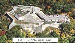
Fort Putnam (2): 1778, West Point. Fort Putnam predates USMA (1802) by nearly 25 years and was Fortress West Point's largest military fortification. Fort Putnam, which overlooks USMA and is situated northeast of Michie Stadium 500 feet above sea level, was the best position to fortify against infantry assault and helped to effectively block British travel on the Hudson during the Revolutionary War. A complete refurbishment of the fort occurred during the nation's Revolutionary War Bicentennial. Cannon and mortars were reproduced and placed according to drawings by Lt. Louis- Alexandre Berthier, a Revolutionary War topographic engineer.
For more information go to http://www.usma.army.mil/tour/.
For pictures see www.antonucci.org/photoecho/westpt.html
[Description of image]
Fort Putnam, West Point
County: (1) Kings County (2) Orange County
City, State: (1) Brooklyn, New York (2) West Point, New York